
Water of Ken
| Water of Ken | ||
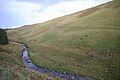
 The Water of Ken near St John's Town of Dalry |
||
| Data | ||
| location | Dumfries and Galloway , Scotland | |
| River system | Dee | |
| Drain over | Dee → Solway Firth → Irish Sea | |
| source | South of Blacklorg Hill 55 ° 18 ′ 14 ″ N , 4 ° 6 ′ 35 ″ W |
|
| Source height | around 570 m ASL | |
| muzzle | In Loch Ken coordinates: 55 ° 3 ′ 17 " N , 4 ° 7 ′ 40" W 55 ° 3 ′ 17 " N , 4 ° 7 ′ 40" W. |
|
| Mouth height | around 46 m ASL | |
| Height difference | around 524 m | |
| Bottom slope | around 11 ‰ | |
| length | 46 km | |
| Right tributaries | Water of Deugh | |
| Flowing lakes | Earlstoun Loch , Loch Ken | |
| Reservoirs flowed through | Kendoon Hole , Carsfad Hole | |
The Water of Ken is a river in the Scottish council area Dumfries and Galloway , or the traditional county of Kirkcudbrightshire .
course
The river rises at a height of 570 m on the southern slopes of the Blacklorg Hills on the northern edge of Dumfries and Galloway just a few hundred meters southeast of the border with East Ayrshire . It flows mainly in a south-westerly direction. After about 20 km, the Water of Ken reaches the reservoir Kendoon Loch , where it receives its largest inflow with the Water of Deugh . A few kilometers to the south, the river reaches another reservoir with the Carsfad Loch . Two kilometers south it enters Earlstoun Loch . Between Earlstoun Loch and the mouth in Loch Ken , the Water of Ken passes St John's Town of Dalry, the largest settlement along its course through a sparsely populated region. The Dee , in which the Water of Ken rises , also flows into the elongated Loch Ken . With a mouth height of around 46 m, the 46 km long river overcomes a height difference of 524 m on its course.
Numerous streams flow into the Water of Ken along its course, but apart from the Water of Deugh it has no significant tributaries. It runs through a sparsely populated region, so that it affects few localities.
Upper reaches of the Water of Ken
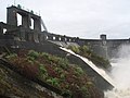
Dam of the Earltouns Hole


Buildings
The Ken Bridge spans the river near New Galloway, a protected Category A monument. The five-arched stone bridge was built in 1824 based on a design by the important Scottish civil engineer John Rennie . Tower House Earlstoun Castle , built in the late 16th or early 17th century, is on the left bank of Ken near St John's Town of Dalry.
Web links
Individual evidence
- ↑ a b c d Ken in: FH Groome: Ordnance Gazetteer of Scotland: A Survey of Scottish Topography, Statistical, Biographical and Historical. , Grange Publishing, Edinburgh, 1885.
- ↑ a b c Entry in the Gazetteer for Scotland
- ↑ Listed Building - Entry . In: Historic Scotland .
- ↑ Listed Building - Entry . In: Historic Scotland .