
Dee (Solway Firth)
|
Dee Dè / Uisge Dhè / Black Water of Dee |
||||||||
 the Dee at Kirkcudbright |
||||||||
| Data | ||||||||
| location | Dumfries and Galloway , Scotland | |||||||
| River system | Dee | |||||||
| River basin district | Solway Tweed XRBD | |||||||
| source |
Loch Dee (lake) 55 ° 4 ′ 58 " N , 4 ° 23 ′ 56" W. |
|||||||
| Source height | 225 m ASL | |||||||
| muzzle | Kirkcudbright Bay Coordinates: 54 ° 48 '12 " N , 4 ° 4' 11" W 54 ° 48 '12 " N , 4 ° 4' 11" W. |
|||||||
| Mouth height | 0 m ASL | |||||||
| Height difference | 225 m | |||||||
| Bottom slope | 3.7 ‰ | |||||||
| length | 61 km | |||||||
| Catchment area | around 1050 km² | |||||||
| Left tributaries | Cooran Lane, Curnelloch Burn, Garray Burn, Carlingware Lane Canal and Auchlane Burn | |||||||
| Right tributaries | Craigancallie Lane, Pullaugh Burn, Glengainoch Burn, Stroan Burn, Crae Lane, Black Bridge Burn and Tarff Water | |||||||
| Flowing lakes | Loch Dee, Stroan Loch, Loch Ken | |||||||
| Reservoirs flowed through | Clatteringshaw's Hole | |||||||
| Small towns | Kirkcudbright | |||||||
| Communities | Bridge of Dee , Crossmichael , Glenlochar , Parton , Tongland | |||||||
| Ports | Kirkcudbright | |||||||
|
||||||||
 Upper course of the Dee |
||||||||

The Dee ( Scottish Gaelic : Dè or Uisge Dhè ) is a 61 km long river in the Scottish council area Dumfries and Galloway in the southwest of the Central Lowlands . It has its source in Loch Dee , flows through the Galloway hills and flows into Kirkcudbright Bay on the Solway Firth in the Irish Sea . The river name is derived from the Latin word Deva (Deus), and means god or goddess. In addition to the Dee in Galloway, there are four other rivers of that name in Great Britain . One is in Ireland , one in Cumbria ( Dee ), one Dee flows in the border area between Wales and England and another Dee in the Scottish Council Area Aberdeenshire .
Course of the river
The Dee rises in the hills between South Ayrshire and Dumfries and Galloway in Loch Dee, which is fed by three tributaries. It then flows northeastwards until it meets Cooran Lane , a left tributary that rises in the western slopes of the Rhinns of Kells . In its upper reaches, the Dee is often referred to as the Black Water of Dee up to Loch Ken . It bends at the confluence almost at right angles towards the southeast and takes on another eastern tributary, the Curnelloch Burn , and winds through a valley west of the Rhinns of Kells. It then unites with Craigancallie Lane , which joins from the south and the Garrary Burn from the northeast. A little further to the southeast, it forms the Clatteringshaws Loch reservoir, which was built for energy generation . After the reservoir, a bridge provides the opportunity to cross the river on the A712 (also known as "The Queen's way"), which runs from Newton Stewart via New Galloway to Crocketford , where it meets the A75 .
From the south, the Pullaugh Burn , which comes down from Loch Grannoch , flows a little further downstream into the Dee, which is flanked on both sides by the “Raiders road” as far as the next bridge. After the bridge, the Dee takes on two other tributaries, the Glengainoch Burn and the Stroan Burn from the south. The "Raiders road" continues to follow the course of the river on the northeastern bank to Lake Stroan Loch . The Dee turns in a bend in the river at Slogarie in a north-easterly direction, takes Crae Lane from the left , can be crossed again shortly afterwards on the A762 and reaches Loch Ken near the village of Parton , which it also partially flows through.
In the lower reaches of the river, on an eight hectare river island, are the remains of Threave Castle , which was the ancestral seat of the so-called Black Douglas dynasty in the 14th and 15th centuries . The Carlingware Lane Canal flows into the two enclosing river arms on the left and the Black Bridge Burn on the right. Near the village of Tongland , the river was channeled over a length of about three kilometers to supply a hydropower station from the 1930s with energy. Before the Dee in Kirkcudbright on the Solway Firth in the Kirkcudbright Bay in the (already by the tidal touched) Solway Firth opens, he takes on two other tributaries. These are the Auchlane Burn from the east and the western Tarff Water , which flow into the Dee at Tongland .
There is a seven and a half kilometer hiking trail along the river between Kirkcudbright and Tongland . The Dee is crossed by bridges in several places, including the Tongland Bridge , which was designed by the British civil engineer Thomas Telford in 1806. The Old Tongland Bridge , a short distance upstream, was built in 1737.

Tongland Bridge by Thomas Telford
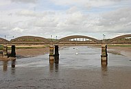
Bridge at Kirkcudbright
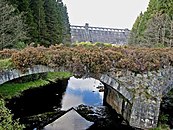
Bridge on Clatteringshaws Reservoir


history
On June 29, 1308, fighting in the First Scottish War of Independence broke out at a ford of the river near Dalbeattie . One of the MacDougall clan chiefs called on the Galloway men to rise up against Robert the Bruce . The troops of the Irish High King Edward Bruce , Robert's brother, and the Scottish supporters of the British royalists faced each other. These were led by Dungal MacDougall, who was a vassal of the British King Edward I until his death in 1307 and who occupied the lands around Galloway. In 1307 the MacDougalls had captured two brothers (Thomas and Alexander) of Robert and Edward Bruce there and handed them over to the English king, who had them executed. Although the MacDougalls were militarily supported by Sir Ingram de Umfraville , they were defeated by Bruce in this battle. MacDougall was captured by Edward Bruce.
Use of hydropower to generate electricity
The Galloway Dee , like the neighboring rivers Water of Ken and Doon , has been used to generate electricity from hydropower since the 1930s. The idea of using the rivers goes back to the late 19th century. But it was not until 1923 that the engineer William McLellan presented concrete plans. The basis for their implementation was a law that was passed by the British Parliament in 1929 and led to the establishment of the Galloway Water Power Company . Work began in 1931 and ended with the completion of the facilities in 1937. This included the partial canalization of the river beds, the construction of dams and the five power plants Kendoon , Carsfad , Earlstoun , Glenlee on the Water of Ken and on the Doon and Tongland on the Dee . In the area of the Dee , the Clatteringshaws Loch reservoir was also built, from which the water is led through a 5.8 km long tunnel to the Glenlee Power Station . Since the rivers are rich in sea trout and salmon , there were fish ladders at the barrages and power stations from the start .
Literature and maps
- Thomas R. Collin: Bridging the Dee at Kirkcudbright. Forward Press, Castle Douglas 1981, OCLC 505060931 .
- Ordnance Survey , Publisher: Topographic Map 1: 50,000, Landranger Map , Sheets 77 Dalmellington & New Galloway and 84 Dumfries & Castle Douglas.
Web links
- Kirkcudbrightshire Dee on the Galloway Fisheries Trust
- About the Kirkcudbrightshire Dee on fishpal.com
- The Royal Society of Edinburgh: Dumfries and Galloway - Galloway Waterways (PDF)
- Loch Ken and River Dee Marshes at jncc.defra.gov.uk
- Lochs of the Dee (Kirkcudbright) basin on maps.nls.uk
Individual evidence
- ↑ a b Please enter "Loch Dee" or "Kirkcudbright Bay"
- ↑ Kirkcudbrightshire Dee on Galloway Fisheries Trust
- ^ William Smith: Dictionary of Greek and Roman Geography. Little, Brown & Co., Boston 1854 ( DAAE, DECIUM, DEVA )
- ^ Threave Castle - A Stronghold of the Black Douglases, Kirkcudbright, Dumfries and Galloway, Scotland. aboutscotland.com, accessed June 11, 2015 .
- ^ River Dee walk, Kirkcudbright. co.uk, accessed June 11, 2015 .
- ↑ Kwebs Bell: Telford's Bridge at Tongland. kirkcudbright.co, accessed June 11, 2015 .
- ↑ Listed Building - Entry . In: Historic Scotland .
- ↑ Fergus DH Macdowall, William L. MacDougall: The MacDowalls Clan MacDougall Society of North America, Parkton, 2009, ISBN 978-0-578-02679-4 , p. 8
- ^ Sarah Crome: Scotland's first war of independence. A Chronicle of the Struggle Fought and Won by Wallace and Bruce. Also Books, Alford 1999, ISBN 0-9536316-0-5 , p. 104.
- ^ The MacDonalds of the Isle. In: George Eyre-Todd: The Highland clans of Scotland. Their history and traditions. D. Appleton, New York 1923, pp. 232 f. ( Text archive - Internet Archive )
- ^ Engineering Timelines - Galloway Hydroelectric Scheme. In: engineering-timelines.com. Retrieved on June 11, 2015 (website for the use of hydropower on the Dee).