Rhinns of Kells
| Rhinns of Kells | ||
|---|---|---|
|
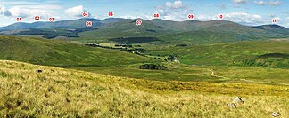
The Rhinns of Kells as seen from Cairnsmore |
||
| Highest peak | Corserine ( 814 m ) | |
| location | Scotland | |
| part of | Galloway Hills, Southern Uplands | |
|
|
||
| Coordinates | 55 ° 9 ′ N , 4 ° 22 ′ W | |
As Rhinns of Kells , a mountain range in the area is Dumfries and Galloway in Scotland called.
Origin of name
The part of the name Rinn, Rhin or Rhinn stands for a promontory, a headland or a peninsula and is particularly found in the Gaelic language for place names. The Rhins of Galloway , a peninsula on the Galloway coast, also has this part of the name. Kells is probably an Anglicization of the Irish name Ceanannas, as is the case with the Irish city of Kells . In terms of meaning, it is cell or kell of Gaelic origin and means a refuge, an incision or a niche. The name Rhinns of Kells testifies to the fact that the Irish settled here in the south-west and west of the country.
geology
The surface of today's landscape was formed in the ice ages of the last 2.4 million years. Erosion, ice grinding, meltwater flows and sediment deposits in the river valleys and on the sea banks formed today's channel-like surface of the landscape. The rocky limestone subsoil with sandstone layers from the geological system of the Silurian was given its present structure. Some of the hills south of Loch Doon, such as Mullwharchar, are made of granite rock . The highest mountain in the area, the Merrick (843 m) and the Rhinns of Kells are outside the granite zone. Rather, the sandstone was hardened to a weather- and erosion-resistant rock by ascending penetrating magma. The Rhinns of Kells have therefore been preserved as elevations in the surrounding landscape, the subsurface of which consists of the deposits of the Silurian Sea.
background
The Rhinns of Kells are part of the Galloway Hills which in turn belong to the Southern Uplands in southern Scotland. They extend for around 300 square miles . The range of hills runs north-south along the eastern boundary of Galloway Forest Park. This area has been called "the cradle of Scottish independence" because Robert the Bruce hid there with his allies from the English troops in the early 14th century. The highest peaks of the Rhinns of Kells, enumerated from north to south, are the Black Craig (528 m), Coran of Portmark (623 m), Meaul (695 m), Carlin's Cairn (807 m), Corserine (814 m), Millfire (716 m), Milldown (738 m) Meikle Millyea (746 m), Little Millyea (578 m) and Darrou (479 m). These peaks are among the highest peaks in Galloway.
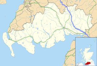
Location of the Rhinns of Kells in Dumfries and Galloway |
The Rhinns of Kells extend about 17 km (as the crow flies) from Black Craig to Darrou. To this mountain range two more chains run north-south, the western one is called "Awful Hand", the Rhinns of Kells are to the east; between the two are the "Dungeon Hills".
The range of hills lies geographically between Loch Doon in the northwest and Loch Dee to the southwest and the Clatteringshaws Loch reservoir , which is southeast of it. To the east are the smaller lakes Loch Harrow and Loch Dungeon . The area east of the mountain range is known as "the Glenkens", which can be traced back to the Ken River and includes the villages of Carsphairn , Dalry , Kells, Parton and Balmaclellan . The Water of Ken unite at Loch Ken with the River Dee which flows into the Irish Sea at Kirkcudbright .
Tourist development

In terms of tourism, the Rhinns of Kells are overshadowed by the northern areas. Although there is no marked network of hiking trails, it is possible to cross most of the treeless hills and peaks. The old farmhouse Craigencallie is ideal as a base for a hike from south to north. The destination of the eight-hour hike would then be the hamlet of Carsphairn. The length of the hike is 29 km, the difference in altitude in ascent and descent 1605 m.
Publications
- Ordnance Survey of England and Wales, and the Isle of Man: Pathfinder series of Great Britain ‹1: 25000› - Rhinns of Kells. (Map). Southampton 1990. OCLC 643161712 .
- Paddy Dillon: Walking in the Galloway hills. Cicerone, Milnthorpe 1995, ISBN 1-85284-168-0 .
- Johann Sölch: Southern Scotland. In: The Landscapes of the British Isles. Volume 2: Scotland and Ireland. doi: 10.1007 / 978-3-7091-7811-9 , pp. 851-874.
Web links
- The Rhinns of Kells - Meikle Millyea to Carlin's Cairn. on backpackingbongos.wordpress.com
- The Parish of Kells. on kirkcudbright.co
- Galloway Climbing - The Rhinns of Kells. on needlesports.com
Individual evidence
- ^ Herbert Maxwell: Rhinns, The . In: Studies in the Topography of Galloway. Being a List of Nearly 4000 Names of Places With Remarks on Their Origin and Meaning, and an Introductory Essay . D. Douglas, Edinburgh 1887, p. 276 ( Textarchiv - Internet Archive ).
- ^ Ceanannas / Kells. logainm.ie, accessed January 7, 2016 (Irish Gaelic).
- ↑ a b The Glenkens in the Olden Times. In: kirkcudbright.co. Retrieved January 8, 2016 .
- ↑ The summits of Corserine, Meikle Millyea and the Rhinns of Kells ridge. ( Memento from January 7, 2016 in the Internet Archive ) on summitpost.org
- ^ Southwest Scotland. A landscape fashioned by geology. ( Memento of August 9, 2017 in the Internet Archive ) (PDF, p. 17.)
- ↑ Alan McKirdy, Roger Crofts: Scotland. The Creation of its Natural Landscape. Scottish Natural Heritage, Perth 2010, ISBN 978-1-85397-671-1 snh.org.uk ( Memento of January 8, 2016 in the Internet Archive ) (PDF).
- ↑ Introduction to the Rhinns of Kells. walkscotland.plus.com, accessed January 7, 2016 .
- ↑ The Parish of Kells. kirkcudbright.co, accessed January 7, 2016 .
- ^ Map of Rhinns of Kells routes. walkscotland.plus.com, accessed January 7, 2016 .
- ↑ Scotland. Topography and geology. beautifulcastles.de, accessed on January 7, 2016 .
- ↑ Route: The Rhinns of Kells. on the Mountains of Scotland website for a description of the walk.


