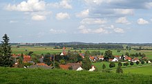
Soft (Jengen)
|
Gives way
community Jengen
Coordinates: 47 ° 59 ′ 54 " N , 10 ° 40 ′ 13" E
|
|
|---|---|
| Height : | 630 m |
| Residents : | 432 |
| Incorporation : | January 1, 1978 |
| Postal code : | 86860 |
| Area code : | 08241 |
Weicht is a district of the Jengen community in the Ostallgäu district in Bavaria .
location
Weicht is located on the eastern edge of a wooded ridge, the Heisteig . The main town Jengen is about four kilometers east of Weicht. The Munich – Lindau A 96 motorway runs a little north of the district . The settlement area of Weicht is drained to the north by the Hungerbach .
history
The many prehistoric finds on the Heisteig suggest that the area around Weicht has been inhabited for thousands of years. Weicht was mentioned in a document as early as the 12th century, at that time under the name Wichte or Wihstein .
From the 16th century, today's spelling is in use. The parish church of St. Vitus dates back to 1430. In the late Middle Ages, part of the village of Hermannstetten, which has since been abandoned, belonged to the parish of Weicht. Weicht's independence ended when it was incorporated into Jengen on January 1, 1978.
Web links
Individual evidence
- ↑ Federal Office for Cartography and Geodesy , State Office for Surveying and Geoinformation Bavaria : Digital Topographical Map 1:50 000, [1] , accessed on January 9, 2016.
- ^ Georg Urban Bacher: Chronicle of the medieval rule Schwabeck , Munich 1846, page 118 ff.
- ↑ History of the place Weicht on the Jengen municipality's website [2] , accessed on February 3, 2016.

