Hungerbach (Gennach)
| Hungerbach | ||
|
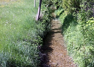
The Hungerbach near Wiedergeltingen |
||
| Data | ||
| Water code | DE : 124632 | |
| location | Bavaria | |
| River system | Danube | |
| Drain over | Gennach → Wertach → Lech → Danube → Black Sea | |
| source | Municipal area of Jengen 47 ° 59 ′ 59 ″ N , 10 ° 40 ′ 33 ″ E |
|
| Source height | 630 m above sea level NHN | |
| muzzle | north of Buchloe in the Gennach coordinates: 48 ° 3 '36 " N , 10 ° 42' 29" E 48 ° 3 '36 " N , 10 ° 42' 29" E |
|
| Mouth height | 601 m above sea level NHN | |
| Height difference | 29 m | |
| Bottom slope | 3.4 ‰ | |
| length | 8.5 km | |
The Hungerbach is a tributary of the Gennach .
course
The Hungerbach rises near Weicht in the Ostallgäu district. It flows through the communities of Jengen , Wiedergeltingen , Amberg and flows north of Buchloe into the Gennach .
Tributaries
- Kleiner Hungerbach (left)
- Tummelbach (right)
Surname
In the municipality of Wiedergeltingen , the Hungerbach is also known as the Großer Hungerbach , in contrast to the Kleiner Hungerbach . Like all "hunger streams" (there is this name in many districts), the stream does not carry water all year round, but mostly only when the snow melts. Only in particularly humid years does water flow continuously. This is where the name comes from: These very humid years used to be years of hunger, as the grain rotted in the still undrained fields.
Despite this uneven water level, a number of mills on the Hungerbach are still recorded in the 19th century, two of them south of Wiedergeltingen towards Weicht and one north towards Amberg.
history
In the 19th century the Hungerbach flowed into the Gennach between Lamerdingen and Ettringen. The Hungerbach was about six kilometers longer at the time. In 1862, parts of the Hungerbach creek were expanded and straightened over a length of around 1.5 km on the upper reaches near Weicht. The course of the stream was also changed in other areas, for example the land consolidations in the 1920s and 1933 by the drainage cooperative in Wiedergeltingen.
Individual evidence
- ↑ Bavarian State Office for the Environment, GIS portal archive link ( Memento of the original from April 9, 2005 in the web archive archive.today ) Info: The archive link was automatically inserted and not yet checked. Please check the original and archive link according to the instructions and then remove this notice.
- ↑ Federal Agency for Cartography and Geodesy , State Office for Surveying and Geoinformation Bavaria : Digital Topographic Map 1:50 000, BayernAtlas , accessed on January 9, 2016
- ↑ Land use plan of the municipality of Wiedergeltingen from 2008
- ^ Johann Thomas Schubert: The Upper Danube District. Nuremberg, [Johann Thomas Schubert] 1836. Supplement 7 to the national work: Bavaria's VIII circles. In: Mapp. XI, 62 q-7. 1836, Retrieved July 2, 2020 .
- ↑ Original position sheets No. 685 and No. 707 of the Bay. Land survey from 1808
- ^ J. Niedermayr: Landwirtschaftliche Blätter für Schwaben and Neuburg , 4th year, Augsburg, 1865, page 101
