
Next junk stalls

The Weite Krambuden is a street in Lübeck's old town .
location
The 50 meter long Weite Krambuden is located in the center of the old town island, in the Marien Quartier . It connects the southern Marienkirchhof with the Markttwiete on the northern edge of the market .
history
The Weite Krambuden is first mentioned in a document in 1307 with the Latin name Platea institorum (Krämerstrasse); In 1309, the names Inter apothecarios (between the pharmacists ), Novae crambodae (new grocer's booths ) and Vicus inter Kemmerboden (lane between grocer's booths ) are documented. The name was derived from the fact that up until the beginning of the 15th century there were initially the sales stalls and later also the houses of the spice dealers and pharmacists. From 1412 to 1442 the council pharmacy was located in house no.3.
In 1332 the name was Vicus apothecariorum (Apothekergasse), 1344 Kemmerboden . In 1354, the name Magnae Cramboden (large Krambuden) was recorded in writing to distinguish it from the neighboring Engen Krambuden . The demarcation to the parallel street is continued in 1370 in the name Latae Cramboden (width Krambuden) and in 1385 in Latae bodae institorum (width shopkeeper).
1388 is the Low German name Wyde Kramboden . The current name was officially established in 1852. The word Weit was used in singular form, although Krambuden is in the plural, so that the street name is now understood in a grammatically curious mixed form as the wide Krambuden .
The historic buildings on the narrow alley, which had previously been closed , were completely destroyed in the bombing of March 29, 1942 . Only the neo-Gothic Marienwerkhaus , which is a corner building of the Marienkirchhof , was not destroyed and is still there today.
Buildings
A selection of the buildings destroyed in 1942 can be found in the list of former Lübeck buildings .
photos

The east side of the wide Krambuden, view from the Markttwiete towards the Marienkirche

Same view, around 1900

The west side of the Wide Krambude around 1910
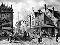
View from Marienkirchhof in the Weiten Krambuden, drawing from 1865


literature
- W. Brehmer : The street names in the city of Lübeck and its suburbs. HG Rathgens, Lübeck 1889.
- W. Brehmer: Lübeck house names along with contributions to the history of individual houses. HG Rathgens, Lübeck 1890.
- Klaus J. Groth : World Heritage Lübeck - Listed Houses. Over 1000 portraits of the listed buildings in the old town. Listed alphabetically by streets. Verlag Schmidt-Römhild, Lübeck 1999, ISBN 3-7950-1231-7 .
- Max Hoffmann: The streets of the city of Lübeck. In: Journal of the Association for Lübeck History and Archeology. Jg. 11, 1909, ISSN 0083-5609 , pp. 215-292 (also special print: 1909).
Coordinates: 53 ° 52 '2 " N , 10 ° 41' 4.6" E