
Wellington Reservoir
| Wellington Reservoir | |||||||||
|---|---|---|---|---|---|---|---|---|---|
 |
|||||||||
|
|||||||||
|
|||||||||
| Coordinates | 33 ° 23 '52 " S , 115 ° 59' 27" O | ||||||||
| Data on the structure | |||||||||
| Construction time: | 1933-1937 | ||||||||
| Power plant output: | 2 MW | ||||||||
| Data on the reservoir | |||||||||
| Altitude (at congestion destination ) | 165 m | ||||||||
| Water surface | 15 km² | ||||||||
| Reservoir length | 16 km | ||||||||
| Reservoir width | 3 km | ||||||||
| Storage space | 185 million m³ | ||||||||

The Wellington Reservoir is a reservoir in the southwest of the Australian state of Western Australia . The dam about 20 km west of Collie is equipped with a water turbine that delivers 2 MW. This hydroelectric power station is one of only two in Western Australia. The northern part of the reservoir is in Wellington National Park .
The dam was built in 1933 and expanded in 1956, and the power plant itself was built in the 1950s.
Wellington Reservoir is the largest in southwest Western Australia and the second largest in all of Western Australia. It lies in the course of the Collie River .
In December 2009, the Water Corporation carried out an AU $ 41 million project to strengthen the dam.
history
The Wellington Reservoir was built in the first half of the 20th century to feed drinking water into the Great Southern Towns Water Supply System - the water supply system for the cities of the Wheatbelt region in Western Australia. This supplied cities in the north to Northam , in the east to Lake Grace and in the south to Katanning . The supply line runs practically parallel to the Goldfields Water Supply Scheme (more precisely from Mundaring Weir to Kalgoorlie ) and the two lines are even connected somewhere.
Wellington Reservoir is fed by the Collie River and its tributaries, which slowly turned salty in the 1960s and 1970s. In the 1980s, a lot of reforestation was carried out there in order to curb the trend towards salinisation. A new reservoir, Lake Ballingall on the Harris River , was completed in the 1990s and supplies the Wellington Reservoir with fresh water until it is free of salt one day.
The Wellington Reservoir was created in 1935 for the irrigation of the agricultural areas in the coastal plain with a capacity of 35 million m³. In the following decades the dam wall was increased several times and in 1960 the lake reached a capacity of 185 million m³.
Gallery images
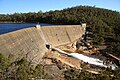
Wellington Reservoir before the 2009 dam reinforcement

Wellington Reservoir under construction (October 2010)

Web links and sources
Individual evidence
- ^ Verve Energy: Hydro Energy . Archived from the original on March 15, 2008. Retrieved March 1, 2008.
- ^ Steve Parish: Australian Touring Atlas . Steve Parish Publishing Pty. Ltd. Acherfield QLD (2007). ISBN 978174193232-4 . P. 80
- ↑ a b 2008 WA Engineering Excellence Awards - 2008 Winners . Retrieved November 27, 2008.
- ^ Department of Water: Upper Collie . Archived from the original on July 21, 2008. Retrieved March 1, 2008.
- ^ Collie Mail: $ 41 million project for Wellington Dam . Retrieved on March 1, 2008. ( Page no longer available , search in web archives ) Info: The link was automatically marked as defective. Please check the link according to the instructions and then remove this notice.
- ^ Wellington Dam Improvement Project . Water Corporation. Archived from the original on July 6, 2011. Retrieved May 2, 2010.