Westweg (Fichtel Mountains)
| Westweg (Fichtel Mountains) | |
|---|---|
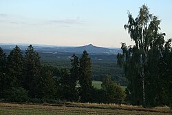
 View from the Westweg to the Rauhen Kulm |
|
| Data | |
| length | 76 km |
| location | Germany, Bavaria , Fichtelgebirge |
| Supervised by | Fichtelgebirgsverein |
| Markers | White "W" on a red background W |
| Starting point |
Münchberg 50 ° 11 ′ 21.1 ″ N , 11 ° 47 ′ 28.6 ″ E |
| Target point |
Rauher Kulm 49 ° 49 ′ 41.3 " N , 11 ° 50 ′ 58.6" E |
| Type | Main hiking trail |
| Level of difficulty | light |
| season | Spring to autumn |
The Westweg is a 76 km long hiking trail on the western edge of the Fichtelgebirge .
course
It runs in a north-south direction from Münchberg to Rauhen Kulm . He touches the geographical points Weißenstein , Streitau , Gefrees , Ölschnitztal , Bad Berneck , Weißmaintal , Königsheide , Haidenaabquelle , Ahornberg , Immenreuth , Kemnath and Kastl . Because of its numerous wide views, it can also be characterized as a panoramic path.
Labelling
The Westweg is looked after by the Fichtelgebirgsverein and is one of the association's main hiking trails, which form the backbone of the Fichtelgebirgsverein's network of trails. The waymarking sign is a white W on a red, rectangular mirror.