Whataroa River
| Whataroa River | ||
|
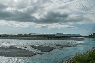
View not far from the Butler River tributary to the southwest of the river |
||
| Data | ||
| location | West Coast , South Island , New Zealand | |
| glacier |
Whymper Glacier 43 ° 29 ′ 0 ″ S , 170 ° 22 ′ 0 ″ E |
|
| Source height | 1180 m approx. | |
| muzzle |
Tasman Sea Coordinates: 43 ° 7 ′ 11 " S , 170 ° 15 ′ 6" E 43 ° 7 ′ 11 " S , 170 ° 15 ′ 6" E |
|
| Mouth height | 0 m | |
| Height difference | 1180 m | |
| Bottom slope | 20 ‰ | |
| length | 60 km | |
| Left tributaries | numerous creeks (mountain streams) | |
| Right tributaries | Butler River , Perth River , Little Man River , Rotokino River and numerous creeks (mountain streams) | |
|
View from New Zealand State Highway 6 to the northwest across the river |
||
The Whataroa River is a 60 km long river in the West Coast region of the South Island of New Zealand .
geography
The river has its origin in the glacier water of the Whymper Glacier of the Tiritiri-o-te-moana , the Southern Alps (southern Alps), south of the peaks of the Hochstetter Dome ( 2810 m ) and ( 2827 m ), Mount Aylmer ( 2699 m ) and Graceful Peak ( 2457 m ). The Aoraki / Mount Cook , New Zealand's highest mountain, is located around 20 km southwest of the headwaters of the river.
The Whataroa River initially flows around 30 km north through the mountains of the Alps, and then, after crossing under New Zealand State Highway 6, meanders through the landscape in the flatter land and in its up to 2 km wide river bed of sediments and rubble to find new ways. The river bed is flanked on both sides in this part of the up to 8 km wide plain by many streams and small canals. In the last quarter of its way, the river makes a wide curve to the left parallel to the Waitangitāhuna River and then flows 14 km northeast of the small settlement Ōkārito in a 2 km wide delta with two arms into the Tasman Sea .
tourism
From New Zealand State Highway 6 , a hiking trail leads through the Whataroa River valley to Whymper Ht . Further hiking trails branch off from the path into the valleys of the Butler River and the Perth River . Even the rafting sports is possible on the river. Here the season from October is given as April.
Web links
Individual evidence
- ↑ a b Whataroa River . In: NZ Topo Map . Gavin Harriss , accessed December 31, 2019 .
- ↑ Coordinates and longitudes were determined using Goggle Earth Pro Version 7.3.2.5776 on December 31, 2019
- ↑ a b Topo maps . Land Information New Zealand , accessed December 31, 2019 .
- ^ Whataroa , Butler and Perth valleys tracks . Department of Conservation , accessed December 31, 2019 .
- ^ Whataroa River, New Zealand . International Rafting Federation , accessed December 31, 2019 .

