Wiang Kum Kam

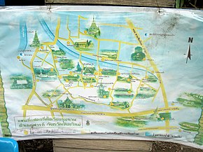
Wiang Kum Kam ( Thai : เวียง กุม กาม , such as: fortified royal residence ) is a restored settlement on the west bank of the Ping River ( Ping River ), about five kilometers south of the present city of Chiang Mai in the district Saraphi , Chiang Mai Province , Northern Thailand .
founding
After King Mengrai conquered Hariphunchai (now Lamphun ), the capital of the Mon Empire, in 1281 , he had his residence in Lamphun for five years. In 1287 he wanted to found a "New City" (Thai: เชียงใหม่ , Chiang Mai ) and moved his farm northwards into an arch of the Ping River, which offered a natural line of defense in the north and east. Archaeological excavations show that he built a rectangular city fortified with palisades ( Wiang - เวียง ) measuring 850 meters × 1600 meters. In this fortification he built a market, around it houses and temples, as well as an "extensive royal palace with many buildings".
When the military complex was completed, he took care of the religious needs of its residents. He had a temple ( Wat ) built with a Chedi , which he designed based on the model of the Chedi Ku Khut of Wat Chamadevi in Lamphun. He called the Tempe "Wat Ku Kham" (today: Wat Chedi Liam ). Numerous other temples soon followed.
After five years in Wiang Kum Kam, Mengrai again moved his residence not far north, directly south of today's Wat Chiang Man . There he founded today's city of Chiang Mai on March 27, 1292.
Around the beginning of the 16th century, Wiang Kum Kam was hit by a devastating flood, which left a meter-thick layer of mud on the entire area, which became uninhabitable. At that time, the Ping River also changed its course; it now flows west of the old settlement. An exact date of the flood cannot be determined. However, archaeologists suspect that it must have happened between 1558 and 1774. However, it is reported in the chronicles that in 1524/25 the area of today's Thapae Gate was flooded and that many people drowned. Some historians speculate that this could possibly have been the end of Wiang Kum Kam. The old settlement was then forgotten.
Excavations
In 1986 and 1987, scientists from Chiang Mai University conducted research in an area between the Chiang Mai southern bypass (Highway 1141) and the Chiang Mai-Lamphun Road (Highway 106) to verify the truth of the "legendary city" . They were initially able to restore Wat Chang Kam in the center of the historic settlement, as well as Wat Chedi Lieam in the northwest. Work ceased in the mid-1990s, but since 2001/2002 the foundations of around 30 temples have been gradually exposed in the middle of a modern housing estate.
Attractions
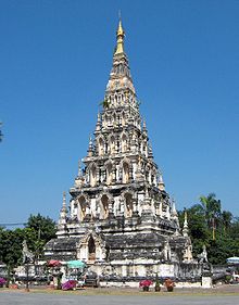
- Wat Chedi Liam (Thai: วัด เจดีย์ เหลี่ยม , also: Wat Ku Kham วัด กู่ คำ ) - a temple that is still active today and was built by King Mengrai in 1288. The step-shaped chedi in Dvaravati style is remarkable , with a square base the size of “eight wah and one sok” and a height of 22 wah, with niches on all four sides containing standing Buddha statues . There are 15 niches on each side for a total of 60 - this number is said to refer to the 60 wives of King Mengrai. The top of the chedi is crowned by a Burmese umbrella (" Hti "), which was probably placed on it during a restoration by a Burmese trader at the beginning of the 20th century.
- Wat Kan Thom ( วัด กาน โถม ), also: Wat Chang Kham ( ช้าง ค้ำ ) - also active today, built in 1291 by King Mengrai. The Chedi shape typical for Lan Na is worth seeing : on a cube-shaped substructure with an edge length of 12 meters, which rests on a multi-stepped base, there is a stupa in Burmese style, which is also crowned by an " Hti ". During excavations, many small votive tablets made of clay were found here, on which Buddha figures in the Hariphunchai style were depicted and characters of the Mon script were covered.
- Wat Pu Pia ( วัด ปู่ เปี้ ย ) - was hidden under two meters of earth in an orchard before being exposed. It is located directly on the western city wall and consists of an ubosot , a wihan , to which a staircase decorated with Naga heads leads, and a chedi. The name was given to the temple by the residents of the area, as its name is not mentioned in any historical document.
literature
- Garry Harbottle-Johnson: Wieng Kum Kam, Atlantis of Lan Na . Chiang Mai 2002, ISBN 974-85439-8-6 .
Individual evidence
- ↑ Harbottle-Johnson: Wieng Kum Kam , page 25
- ↑ Flyer of the Wiang Kum Kam Information Center from 2005
- ↑ A wah (historical measure of length) = about two meters; a sok = about 50 centimeters
- ↑ Harbottle-Johnson: Wieng Kum Kam , page 57
Web links
- The Origins of Wiang Kum Kam ( Memento from April 23, 2011 in the Internet Archive ), page of the "e-Magazine" of the Thai TAT (English)
Coordinates: 18 ° 45 ′ 14.7 ″ N , 98 ° 59 ′ 44 ″ E


