Wilhelmstrasse (Wesel)
| Wilhelmstrasse | |
|---|---|
| Street in Wesel | |
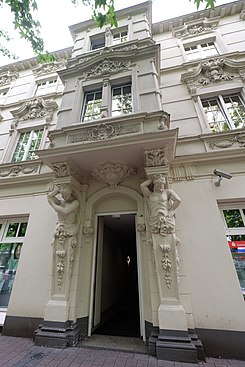
| Baroque bank building on Wilhelmstrasse | |
| Basic data | |
| place | Wesel |
| District | Old town (but not historical) |
| Buildings | Berliner Tor (adjacent), baroque bank building, Scala Kulturspielhaus |
| use | |
| User groups | Motor vehicles , pedestrian traffic , bicycle traffic |
| Technical specifications | |
| Street length | 146 m |
The Wilhelmstrasse is a downtown street of Wesel on the Lower Rhine.
location
Wilhelmstrasse is in the east of Wesel city center and runs between the forecourt of Wesel train station and the Berliner Tor . At the same time, the 146-meter-long street is part of an axis that runs from the train station to the Großer Markt in an east-west direction through the city center. While Wilhelmstrasse is passable, the remaining sections - beginning with Berliner-Tor-Platz - are designed as a pedestrian zone and form Wesel's central shopping street. Wilhelmstrasse also has a high number of retail businesses, but the number of shops and pedestrian frequency is significantly lower than in the central areas of the pedestrian zone. It is designed like an avenue and allows a direct view of the Berliner Tor from the station forecourt. At its eastern and southeastern end, Wilhelmstrasse is crossed by the Kaiserring as part of Bundesstrasse 58 . The station forecourt to the east is not passable.
History and buildings
The area of today's Wilhelmstrasse was neither part of the medieval old town nor the Mathena suburb , which grew in the late Middle Ages . Since Wesel became a fortress town in the late 17th century and the Berliner Tor, built in 1718, represented its eastern boundary, an expansion of urban development into this area was initially ruled out. The station was built in the middle of the 19th century in its current position and was therefore outside the fortress walls, but the area between the station and the Berliner Tor remained undeveloped. In 1886 a commission proposed that the city should be de-fortified, which could be initiated in 1890 after a contract had been signed. Within a few years there was brisk construction activity on Wilhelmstrasse and the surrounding streets such as Augustastrasse. Above all, representative buildings of the upper class emerged, some of which were shaped by Art Nouveau . Only a few years after 1890, Wilhelmstrasse had almost continuous development. The name of the street was chosen by the city council and, in view of the patriotism that was spreading at the time, was based on Kaiser Wilhelm I as a model. In addition to many residential buildings, a branch of the Reichsbank was built on Wilhelmstrasse , which had its regional headquarters there from 1895 to 1943.
There was considerable destruction in the Second World War . During the reconstruction, the inner city axis, which also included Wilhelmstrasse, was to become the central business area again. Plans from 1946 also provided for an underpass from Wilhelmstrasse through the station area to the district of Fusternberg and the Wackenbrucher Strasse located there. However, the latter was not implemented. After the proposal to rename Wilhelmstrasse to Vesaliastrasse in February 1947, the entire inner city axis was named Hohe Strasse in the summer of 1947. In July 1949, the streets were given their previous names (Wilhelmstraße, Berliner-Tor-Platz, Hohe Straße , Viehor and Brückstraße ) after considerable protests from residents. In 1951 the Wesel – Rees – Emmerich small railway was put back into operation and, unlike before the war, also ran along the inner city axis and Wilhelmstraße. The closest stops were at Berliner-Tor-Platz and at the train station. 1966 the operation of the small railway was stopped.
The neo-baroque commercial building, which had been used by the Reichsbank from 1895, was restored in its old form after the war and from then on served the local savings bank. The main building of today's Niederrheinische Sparkasse RheinLippe today comprises an entire building complex along Bismarckstrasse, Wilhelmstrasse and Augustastrasse, which also includes the historic building on Wilhelmstrasse. As a cultural institution, the Scala cinema was opened on Wilhelmstrasse in 1951 as the third cinema in the city. At the end of 2005 it ceased operations. In February 2014, the Scala Kulturspielhaus was set up in the former cinema .
Individual evidence
- ↑ Street directory 46483 ( Memento of the original from 23 August 2016 in the Internet Archive ) Info: The archive link was inserted automatically and has not yet been checked. Please check the original and archive link according to the instructions and then remove this notice. (strassenverzeichnis.deutschlandblick.com)
- ↑ Concept for the development of the inner city of Wesel (wesel.de)
- ↑ The Berliner Tor is the last city gate - but it is tight (derwesten.de)
- ↑ Wesel: Wesel - the constricted city (rp-online.de)
- ↑ Communication No. 152 (historical-vereinigung-wesel.de)
- ↑ Streets in Wesel - Letter W (wesel.de)
- ↑ Martin Wilhelm Roelen, Doris Rudolfs-Terfurth (Ed.): The reconstruction of the city of Wesel, p. 172
- ^ Martin Wilhelm Roelen, Doris Rudolfs-Terfurth (ed.): The reconstruction of the city of Wesel, p. 38
- ^ Martin Wilhelm Roelen, Doris Rudolfs-Terfurth (ed.): The reconstruction of the city of Wesel, p. 15, p. 17
- ↑ June 8, 1951 - A tram for Wesel (wesel.de)
- ↑ Martin Wilhelm Roelen, Doris Rudolfs-Terfurth (ed.): The reconstruction of the city of Wesel, p. 192
- ↑ Memories of the good old days of the Scala cinema (rp-online.de)
- ↑ The Ex-Scala becomes the Kulturspielhaus (rp-online.de)
Coordinates: 51 ° 39 '24.6 " N , 6 ° 37' 24.7" E
