Windmill Tump
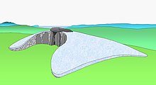
Windmill Tump (also called Rodmarton Long Barrow) is a Neolithic cairn or tumulus south-west of the village of Rodmarton, south of the road between Cherington and Tarlton in Gloucestershire , England , on which trees grow.

Between 3000 and 2500 BC The structure that originated in BC consists of about 5,000 tons of stone under a mound of earth. The west-east oriented Cotswold Severn Tomb is about 21.0 m wide and 60.0 m long. The only visible stones are part of a false door ( English false entrance or false door ) on the east side of the hill.
Excavations took place in 1863 and 1939, with the hill being restored. On the side of the hill, in the front part, behind the false entrance, there are two chambers with soul hole entrances to the north and south. They contained the remains of ten adults and three children. Animal remains, including boar tusks, horse teeth, and cattle bones, were also discovered. Two stones about 2.6 m high and a third, larger stone leaning against it, apparently placed in this position, were uncovered during the first excavation. This particular arrangement was similar to that of tumuli in Kilkenny , Ireland and Cornwall . The third stone was probably used as a sacrificial altar. Another chamber was later discovered to the west at the back of the north side of the hill. It was partially cut into the ground and accessible via stairs.
Evidence of a structured curb and stabilizing transverse walls in the hill was also provided. Today the hill is largely framed by modern dry stone masonry and surrounded by a wooden fence.
literature
- Timothy C. Darvill: Long barrows of the Cotswolds and surrounding areas . Tempus Books, Stroud 2004. ISBN 0-7524-2907-8 .
- Jürgen E. Walkowitz: The megalithic syndrome. European cult sites of the Stone Age (= contributions to the prehistory and early history of Central Europe. Vol. 36). Beier & Beran, Langenweißbach 2003, ISBN 3-930036-70-3 .
Web links
Coordinates: 51 ° 40 ′ 28.3 " N , 2 ° 5 ′ 56.4" W.

