Wolwelingen
|
Wolwelingen ( German ) Wolwen ( lux. ) Wolwelange ( French ) Rambruch parish
|
||
|---|---|---|
| Coordinates : | 49 ° 49 ' N , 5 ° 53' E | |
| Postal code : | 8833 | |
|
Location of Wolwelingen in Luxembourg
|
||
|
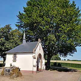
Wolwelinger Klause, in the foreground stump of tungsten beech
|
||
Wolwelingen ( Luxembourgish Wolwen , French Wolwelange ) is a village in the municipality of Rambruch in the canton of Redingen in the Grand Duchy of Luxembourg
location
Wolwelingen is located in the west of Luxembourg on the border with Belgium . The CR 311 runs through the town, it connects the town with the neighboring towns of Obermartelingen and Bondorf . Another neighboring town is Perl in the south.
General and history
A church in Wolwelingen is mentioned as early as 1330. At the eastern entrance to the village is the Wolwelinger Klause , consisting of a green area and a small chapel. The so-called Wolframsbich (Wolframsbuche), a beech that had to be felled in 2014 because it had become too unstable, stood next to the chapel for centuries . Worwelingen thus lost a striking landmark. In the center of the village is the parish church of St. Peter and Paul, which was built in 1785. The previous building stood on the site of the Wolwelinger Klause.


