Xitle
| Xitle | ||
|---|---|---|
|
The Xitle volcano in Mexico. |
||
| height | 3105 m | |
| location | Federal District , Mexico | |
| Coordinates | 19 ° 14 ′ 48 ″ N , 99 ° 13 ′ 19 ″ W | |
|
|
||
| Type | Cinder cone | |
| Last eruption | 315 | |

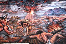
The volcano Xitle ( Nahuatl for navel ) rises in the Cumbres del Ajusco National Park of the federal capital district of Mexico City in Mexico - more precisely in the village of Lomas de Tepemecatl in the largest administrative district of the city, Tlalpan . It is an approximately 200 meter high cinder and ash cone , the summit of which, however, extends to over 3000 meters due to the plateau. Its crater is located about 22.5 kilometers as the crow flies south-southwest of the Plaza de la Constitución , the center of the metropolis.
As part of the approximately 90-kilometer Chichinautzin - volcanic field - for example, which also includes only 5.7 kilometers southwest location Ajusco belongs - marked the Xitle whose last known activity. Geological measurements using the radiocarbon method showed an eruption between the years 245 and 315. Large amounts of lava flowed mainly in a north-northeast direction and formed the extensive Pedregal de San Ángel lava field . In the course of the eruption, the flourishing city of Cuicuilco , which was of great regional importance, was largely destroyed. The inhabitants left their homeland and probably mostly settled in Teotihuacán , about 56 kilometers away , which in turn experienced a significant cultural boom.
The volcanism in the area of the Xitle is monogenetic . This means that only one eruption phase per eruption cone can be expected.
Web links
- The Chichinautzin-volcanic field in the Global Volcanism Program of the Smithsonian Institution (English)
- Map of the lava flows of the Xitle . Retrieved from specialpapers.gsapubs.org ( Geological Society of America ) on March 21, 2016.

