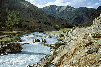
Yapola
|
Yapola Wanla |
||
|
Yapola near Wanla |
||
| Data | ||
| location | Ladakh ( India ) | |
| River system | Indus | |
| Drain over | Indus → Arabian Sea | |
| source |
Zanskar Range ( Himalayas ) 34 ° 2 ′ 35 ″ N , 77 ° 5 ′ 45 ″ E |
|
| Source height | approx. 5400 m | |
| muzzle |
Indus coordinates: 34 ° 19 ′ 56 " N , 76 ° 50 ′ 13" E 34 ° 19 ′ 56 " N , 76 ° 50 ′ 13" E
|
|
| length | approx. 55 km | |
| Catchment area | approx. 1100 km² | |
| Communities | Wanla | |
The Yapola River (also Wanla ) is a left tributary of the Indus in India .
The Yapola flows through the northern part of the Zanskar chain in Ladakh . It flows in a predominantly north-westerly direction and passes the village of Wanla . 4 kilometers east of Lamayuru the Yapola turns north and flows into the Indus after another 7.5 km. The Yapola has a length of 55 km. Its catchment area covers around 1100 km².
Web links
Commons : Yapola - collection of images, videos and audio files
