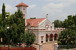
Yavatmal
| Yavatmal | ||
|---|---|---|
|
|
||
| State : |
|
|
| State : | Maharashtra | |
| District : | Yavatmal | |
| Location : | 20 ° 14 ′ N , 78 ° 4 ′ E | |
| Height : | 445 m | |
| Residents : | 116,551 (2011) | |
Yavatmal is a city in the state of Maharashtra in western India . It is the administrative seat of the Yavatmal district of the same name . Yavatmal is divided into 40 wards (constituencies) and is administered as the Municipal Council. It is 669 kilometers from Yavatmal to Mumbai .
history
Yavatmal was once the main city of the Sultanate of Berar . In 1572 Murtaza Shah , ruler of the Ahmadnagar Sultanate , annexed the Yavatmal district. In 1596, Chand Bibi , the regent of Ahmadnagar, ceded Yavatmal to the Mughal Empire , which then ruled over a large part of India. After the death of the sixth Mughal emperor Aurangzeb in 1707, Yavatmal fell to the Maratha Empire . In 1853 it finally fell to the British Empire .
Demographics
The city's population is 116,551 according to the 2011 census. Yavatmal has a gender ratio of 991 women per 1000 men and thus a common surplus of men for India. The literacy rate was 92.0% in 2011. Almost 69.1% of the population are Hindus , approx. 14.9% are Muslims , approx. 12.9% are Buddhists , approx. 2.0% are Jainas , approx 0.7% are Christians and about 0.4% belong to other or no religions. 9.8% of the population are children under six years of age.
Individual evidence
- ↑ www.census2011.co.in
- ↑ Yavatmal City Population Census 2011-2019 | Maharashtra. Retrieved September 16, 2019 .

