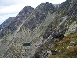
Zadni Staw Gąsienicowy
| Zadni Staw Gąsienicowy | ||
|---|---|---|

|
||
| View of the Zadni Staw Gąsienicowy | ||
| Geographical location | High Tatras , Poland | |
| Drain | Sucha Woda Gąsienicowa | |
| Location close to the shore | Zakopane , Bukowina Tatrzańska | |
| Data | ||
| Coordinates | 49 ° 13 '27 " N , 20 ° 0' 39" E | |
|
|
||
| Altitude above sea level | 1,852 m npm | |
| surface | 0.52 ha | |
| Maximum depth | 8 m | |
|
particularities |
Zadni Staw Gąsienicowy is one of the highest lakes in the High Tatras |
|
The Polish Back Lake ( pl. Zadni Staw Gąsienicowy ) in Poland is a glacial lake in the Seealm Valley ( pl. Dolina Zielona Gąsienicowa ) in the High Tatras . It is located in the municipality of Zakopane . It is not accessible, there is no hiking trail leading to the lake. However, it is clearly visible from the surrounding peaks. Most of the lake's water flows underground via the Seealmer Trockenbach .
Web links
Commons : Zadni Staw Gąsienicowy - collection of pictures, videos and audio files
Individual evidence
- Zofia Radwańska-Paryska, Witold Henryk Paryski, Wielka encyklopedia tatrzańska, Poronin, Wyd. Górskie, 2004, ISBN 83-7104-009-1 .
- Tatry Wysokie słowackie i polskie. Mapa turystyczna 1: 25000, Warszawa, 2005/06, Polkart ISBN 83-87873-26-8 .
