Zakęcie
| Zakęcie | ||
|---|---|---|

|
|
|
| Basic data | ||
| State : | Poland | |
| Voivodeship : | Lebus | |
| Powiat : | Nowa Sól | |
| Gmina : | Otyń | |
| Geographic location : | 51 ° 50 ′ N , 15 ° 41 ′ E | |
| Residents : | ||
| Telephone code : | (+48) 68 | |
| License plate : | FNW | |
| Economy and Transport | ||
| Next international airport : | Poznan-Ławica | |
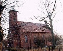
Zakęcie (German Erkelsdorf ) is a village in the municipality of Otyń in the powiat Nowosolski of the Polish Lubusz voivodeship .
Geographical location
Zakęcie is located about two kilometers southwest of Otyń ( Deutsch-Wartenberg ), five kilometers northwest of Nowa Sól ( Neusalz on the Oder ) and 17 kilometers southeast of Zielona Góra ( Grünberg in Silesia ).
history
Zakęcie was mentioned for the first time in 1516 and at that time it was called Eckerstorff. In 1791 the name was changed to Erkelsdorf. In 1844 there were 496 inhabitants, 55 houses, an agricultural and a Catholic school in Erkelsdorf, which was opened in 1801. Erkelsdorf did not have a train station, although there were two rail connections. A railway line ran from Breslau to Grünberg and was built in 1871; the other route dates from 1903–1907 and led from Neusalz to Wollstein . The Catholic Chapel was built in 1913.
The place had 445 inhabitants in 1933 and 428 inhabitants in 1939. Until 1945 it belonged to the Freystadt district in Lower Silesia .
Web links
- Michael Rademacher: German administrative history from the unification of the empire in 1871 to the reunification in 1990. freystadt.html. (Online material for the dissertation, Osnabrück 2006).

