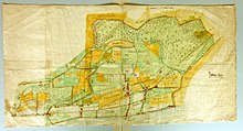
Zollikommer ban
The Zollikommer Bann (today the term Zolliker Zehntenplan is also used) is a map of Zollikon in the canton of Zurich , Switzerland, from the year 1720. It is the oldest known map of the place. The "Zollikommer Bann" is kept in the Zurich State Archives.
purpose
A ban has been in a special area since the 10th century, here Zollikon-Dorf. In order to have an overview of the sources of income to which it was entitled, the governments had tithing plans drawn up, especially in the 17th century , which usually included the area of a community. This gave the authorities an overview of the taxes on the property and thus a complete record of all tithe payers.
description
The plan is called "Zollikommer Bann sampt the same impulses" . It faces east with the lake at the bottom. The sheet is 107 centimeters long and 55.5 centimeters wide. The brittle paper was glued to canvas for stabilization.
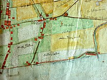
The plan was drawn in ink or Indian ink. It was then colored with watercolors in various shades of green and ocher. It is not known who commissioned it or who drew it.
The area shown is actually approx. 3700 meters long and 3000 meters wide. It does not correspond to today's municipality: On the one hand, the upper part of the village of Zollikerberg is missing , on the other hand, a part of the former municipality of Riesbach is shown on the left. In the south the plan extends as far as the Rumensee , in the north approximately to the Tiefenbrunnen bathing area.
presentation
Vines, meadows, fields and forests are shown. Some of the registered land names are still used today. Several properties owned by the Oetenbach Monastery in Zurich are registered as Ötenbach Güeter . Above is the name Trichtenhausen Güeter ; Trichtenhausen was then the name for the Zollikerberg. At the lake are the Traubenberg and on the right as a long building the Gugger . The reformed church and the rifle house (roughly on the site of today's scout hut) are the only buildings shown as miniature images.
literature
- Urs Bräm: Zollikon - a local customer. 1990

