
Zollikerberg
| Zollikerberg | ||
|---|---|---|
| State : |
|
|
| Canton : |
|
|
| District : | miles | |
| Political community : | Zollikon | |
| Postal code : | 8125 | |
| Coordinates : | 687 965 / 244 563 | |
| Height : | 605 m above sea level M. | |
| Website: | www.quartierverein-zollikerberg.ch | |
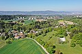
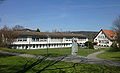
 Zollikerberg, Zurich in the background |
||
| map | ||
|
||


The Zollikerberg is the eastern, higher-lying part of the village of Zollikon in the canton of Zurich in Switzerland . It is separated from the actual village by a ridge and a wide forest belt. There is no mountain called Zollikerberg.
geography
Zollikerberg refers to a rather flat area on the western flank of the Pfannenstiel that does not slope towards Lake Zurich . It is a trough that drops steeply to the Wehrenbach in the western part towards the north . The place is around 600 meters above sea level. The ridge separating the trough from the lake to the south and west reaches a height of 636 meters at Feufbüel and 673 meters further east in Isleren. The Trichterhauser Mühle is around 560 meters above sea level.
The Zollikerberg borders the city of Zurich in the north and northwest , Maur in the northeast, Zumikon in the east and Küsnacht in the south. The border to Zurich runs for long stretches along the Wehrenbach, on the other side of which lies Witikon .
Settlement development

The oldest settlements are probably the Hof in der Unterhueb , the former Trichtenhusen and the Wilhof . The Oberhueb , the Sennhof and the Sonnengarten were added later . The Trichtenhauser Mühle was a single settlement in the ravine of the Wehrenbach.
An increased structural development in the mountain did not begin until the 1920s and 1930s, when the area was opened up by the Forchbahn and new quarters were created on streets laid out along Forchstrasse. There was a real construction boom after the Second World War. Today around 6,000 people live in the Zollikerberg, about the same number as in the village on the lake.

"Im Ahorn" settlement
Districts of Oberhub (left) and Sennhof (right)

The Spitzhütte on the Rüterwis

The Forchbahn in front of Forchstrasse


history
First tracks
In 1913 the oldest finds were discovered in the Zollikerberg. At that time, settlement remains - stones, coal remains and stakes - were found in the Breitmoos area, which probably date from the Bronze Age .
First settlement

The first traces of settlement in the municipality come from the Hallstatt period . At that time five burial mounds were built on the Feufbüel , which are still clearly recognizable today and are called Celtic graves .
In 1968 an iron sword from the Latène period was found in the Oberhub in Zollikerberg . Traces of oxidation suggest a cremation grave , of which, however, no traces remained. Even if there are no traces of settlements, it can be assumed that there were individual farms in the Zollikerberg.

In 1962, during excavation work in the Unterhueb, a field of eleven stone box graves from the 8th and 9th centuries, facing east to west, came to light. The last burial was the well-preserved skeleton of a 50-year-old man. The arrangement of the graves in sandstone slabs and chunks and their distribution suggest a small high medieval burial place, which has been used over and over again for a long time, the main group of which was once in the area of the Sennhofweg, perhaps a little further south, where possibly the one that has been since 1275 The "Chapel of Trichterhausen" was mentioned again but never found.
The two still existing field names Deisten (Dingstatt, court) and Galgenbühl (place of execution) indicate a special meaning of the Zollikerberg. Apparently there was an ecclesiastical and judicial center there, which should go back to the 8th and early 7th centuries.
As there was no source of income in the Zollikerberg, the people lived here in poorer conditions. Hardly 80 people lived in simple clapboard wooden houses.
The new order
The Zollikerberg was initially assigned to Zumikon . Since a vote in 1803 with 48 to 8 votes, he has belonged to Zollikon. Zollikon and the Zollikerberg have formed the political municipality of Zollikon since 1804.
1993 murder case
In 1993, Zollikerberg became known to a wider public through reporting on the murder on Zollikerberg .
traffic
Streets
The old Forchstrasse (also called "Grüninger Strasse") led over the Zollikerberg, then on a different route, past the Sonnengarten restaurant, over the Unterheb to the Chaltenstein and on to the Forch . The connection within the community was made up of narrow paths and cart paths. The new Forchstrasse was built in 1843 with a completely new layout.
Public transport
In 1836 a stagecoach service was set up for the Zurich - Zollikerberg - Forch - Grüningen - Wald route. The carriages ran twice a week, on Fridays and Sundays. Later, the cars drove first daily, then twice a day. From 1903 onwards, “Martini” buses were also used, which were later also assigned to transport the post. The last stagecoach drove on May 31, 1906. On November 27, 1912, the first carriage of the electric Forchbahn , which still connects the Zollikerberg with the city and Esslingen , drove .
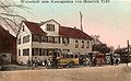
Buses near the rose garden, around 1908

Forchbahn near the rose garden, around 1912
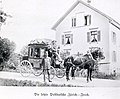
Last stagecoach, May 1906
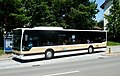
Bus Zurich-Zollikon-Küsnacht


economy
Grain and, since 1760, potatoes were grown for self-sufficiency. Until around the middle of the 18th century, three-field farming was used, then the fallow land was closed and also planted. Since agriculture was more important in the Zollikerberg than in the village, cattle was also raised. Excess milk was sold to Zurich.
Churches
Reformed church Zollikerberg

Until the Reformation, the Zollikerberg formed its own district. In a small chapel - it was on a slightly elevated point on Sennhofweg in the Unterhub - priests from the Grossmünster held the service. After the Reformation the chapel was put out of use. It was first used as a storage facility, but was demolished in 1860.
After the church was built in the neighboring village of Zumikon in 1731, the believers from Zollikerberg attended the service there. The children also went to school in Zumikon and attended confirmation classes there. The confirmation, however, took place in the Zolliker village church. It was not until 1804 that the Zurich government declared all parts of the Zollikerberg to be part of Zollikon. Until 1933, the residents of the various hamlets of the Zollikerberg had to do without their own church. Then the Diakoniewerk Neumünster built a chapel with a tower in which the believers were granted hospitality.
Due to the rapidly growing population, the desire for an own church center arose in the 1940s. In 1943 a separate pastorate was created for the Zollikerberg, and in 1949 a rectory was built. In the spring of 1951, the church administration took up the idea of its own church again. According to plans by the architects Hans and Annemarie Hubacher , the new church and parish hall in Zollikerberg was built between 1958 and 1960. It was inaugurated on December 11, 1960.

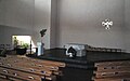
Reformed Church Mountain
inner space

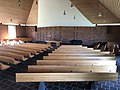
Catholic Church Berg
inner space


Catholic Church Zollikerberg
Around 1805, more and more Catholics settled in Zollikerberg again. Between 1902 and 1927 they belonged to the parish of St. Georg in Küsnacht , then to the parish of St. Anton (Zurich-Hottingen) . At the beginning of 1932 it was replaced by this and, together with Zollikon-Dorf, elevated to the parish of the Holy Trinity .
Before the St. Michaels Church was built, the Catholics celebrated their services in the Schwendenhau Chapel in the Rebwies district. As the number of Catholics grew from year to year, a plot of land for the construction of a Catholic church in Zollikerberg was acquired in the Wilhof in 1952 at a price of CHF 10.- per square meter.
In October 1962, a jury decided on the «Light» project by the architect Karl Higi . On September 20, 1964, Vicar General Dr. Teobaldi laid the foundation stone, and construction was completed at the end of April 1966. On May 19 and 20, 1966, the bells were consecrated by the vicar general and raised by school children. The first service took place on July 10, 1966.
The church can accommodate around 500 people. The pentagonal tower is 32 meters high. The ringing of the five bells, made by the H. Rüetschi foundry in Aarau, is coordinated with that of the Reformed Church.
school
In 1804, a resolution by the government council allocated the Zollikerberg to the municipality of Zollikon-Dorf. His school affiliation was not previously clarified. The children mostly went to school in Zumikon because of the easier route. After 1804, the large number of children attended school in Kleindorf, and some continued to go to Zumikon. A school building planned in 1822 failed for financial reasons. Instead, in the same year, the Weber farmhouse in the Unterhueb was bought for 150 guilders and makeshift rebuilt for school lessons. The first schoolmaster was the local Matthias Brunner. However, the schoolhouse turned out to be unsuitable for teaching purposes and was sold again after two years.
In 1824 work began on building a school house on Sennhofweg, which today houses the Unterhueb kindergarten. At the turn of the century, the new school building no longer met the increased requirements; the number of students had also increased significantly. On April 22, 1912, the new school building - today called Rüterwis C - was inaugurated. The architects were Schindler & Streiff. Just three decades later it got too small too. In 1945 the municipality approved a loan of 660,000 francs for the construction of a new school building with a gym; Construction was completed in 1948. Today's Rüterwis B was built in 1954. The building designed by architect Hans von Meyenburg (1995–1985) is now one of the most artistically valuable school buildings of the 1950s. In 1963 the modern Rüterwis A (architect Karl A. Zink) was created. The new gym was built in 1970/71. In 1991/92 the Rüterwis A was raised by one floor and the roof shape was changed.
In August 2018, the new Rüterwis D schoolhouse was inaugurated, which houses the kindergartens and rooms of the music school. The previous neighborhood kindergartens were closed.
Schoolhouse Rüterwis C, on the right the schoolhouse Unterhueb, around 1915
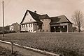
Rüterwis C, around 1915
Rüterwis B and C, 2010

Rüterwis D


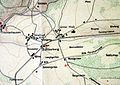
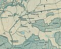
Zollikerberg on old maps

Zollikerberg on the Wild Map from 1848
Map of the Zollikerberg, 1900
Zollikerberg on the route map from 1919


literature
- J. Barth: The economic development of the Zurich suburb of Zollikon. 1955.
- K. Beck: Assumptions about the history of the Zollikerberg. 1966.
- U. Bräm: Zollikon - a local customer. 1990.
- H. Bruppacher: The old Zollikon. 1899.
- H. Glarner: Zolliker years. 1987.
- P. Guyer: 1000 years of Zollikon. Schulthess-Verlag, Zurich 1946.
- A. Heer: Our Zollikon. Zollikon 1968.
- H. Hess, R. Humm, E. Walder: Welcome to Zollikon.
- Wilfried Maurer: The Zolliker village church. Reformed parish of Zollikon, 2004.
- H. Nabholz: The village community in Zollikon. 1940.
Web links
- Quartierverein Zollikerberg
- Website of the municipality of Zollikon
- Statistical data from the canton on the municipality of Zollikon
- Map of the municipality of Zollikon