
Witikon
 quarter of Zurich |
|
|---|---|
 |
|
| Coordinates | 687000 / 245950 |
| height | 604 m |
| surface | 4.93 km² |
| Residents | 11,054 (December 31, 2019) |
| Population density | 2242 inhabitants / km² |
| BFS no. | 261-074 |
| Post Code | 8053 |
| Urban district | District 7 since 1934 |
Witikon is a district of the city of Zurich . The formerly independent municipality Witikon was incorporated in 1934 and is today together with Fluntern , Hottingen and Hirslanden the Kreis 7 . The quarter has had over 11,000 inhabitants since 2019.
coat of arms
- A silver shield fitting in red
geography
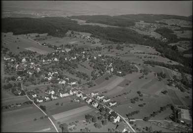
The village in 1949: aerial photo by Werner Friedli , view from the north-west. At the bottom right the school building, left of the center the former turning loop of the bus.

View from Uetliberg to Witikon, Hirslanden (left) and Weinegg (below)

Witikon is located on a terrace around 600 m on the southwest side of the Pfannenstiel chain on the slopes of the Adlisberg ( 701 m ) and the Ötlisberg ( 696 m ). Witikon is surrounded by two deeply cut streams, the Wehrenbachtobel in the south and the Steffenbachtobel - also known as the Elefantenbachtobel - in the north. To the west, on the slope towards Zurich, is the district of Eierbrecht.
An important connecting road from Zurich to the upper Glatt valley runs through Witikon. After Hirslanden , it passes the Steffenbachtobel in the loop, climbs steeply to Witikon, reaches the highest point north of Ötliisberg at 631 m and leads via Pfafffhausen to Fällanden on the Greifensee .
history
The name Vuitinchova (meaning «Hof des Vito») indicates that this farm was founded during the second wave of immigration and the final settlement of the Alemanni in the first half of the 7th century. Previously, as excavations suggest, Celts and the Romans also lived in this area.
The first record of the place comes from 946. A decision of April 28, 946 on the division of the church tithing between Felix and Regula ( Canons' monastery Grossmünster ) and St. Peter (town church) stated that the tithe from «Vuitinchova» was to be paid to the canon monastery .
In the 1910s, Witikon had less than 400 residents.
Incorporation

Witikon, today the easternmost quarter of the city, was incorporated in 1934 together with Albisrieden , Altstetten , Höngg , Oerlikon , Affoltern , Seebach and Schwamendingen as one of the last villages. Important reasons for the incorporation were indebtedness and a bad infrastructure (schools and transport).
Attractions
Its location on the slope of the Adlisberg gives a view of Lake Zurich and the parts of the city in the Limmat Valley. Cannon balls stuck in the wall of the old church in Witikon bear witness to Austrian troops who holed up in the church during the first battle for Zurich and were fired at by French artillery.
An example of modern sacred architecture is the Catholic Church “Maria Krönung” by the architect Justus Dahinden . The floor plan is modeled on the hand with a ship per finger. The walls rise up like a tent, which is reinforced by the lining with long wooden boards. The affiliated Paulus Academy is of great importance in Catholic Switzerland. The bull house from 1982 on Kienastenwiesweg is also by Justus Dahinden . The sculptures on the bullhouse come from the Swiss artist Bruno Weber .
Churches and cemeteries

There are three churches in Witikon: The Evangelical Reformed Church has two places of worship:
- The Old Church of Witikon , which is known as St. Otmar chapel was first mentioned in 1270. The old church Witikon stands on a hill at 629 m above sea level. M. and is thus the highest church in the city of Zurich.
- The New Witikon Church was built between 1955 and 1957 according to plans by the architect Theodor Laubi, Meilen. The New Witikon Church was designed as a hexagonal building with a free-standing church tower . It has a Metzler organ from 1957.
The Roman Catholic Church is represented in Witikon with the parish of Maria Krönung:
- The Maria Krönung Church was built between 1963 and 1965 according to plans by the architect Justus Dahinden . After the Church of All Saints (Zurich-Neuaffoltern), the coronation of Mary is the second new Catholic church in the city of Zurich, in which the Constitution on the Holy Liturgy of the Second Vatican Council was implemented.
There are three cemeteries in Witikon, which are special among the 26 cemeteries in Zurich for different reasons:
- The historic churchyard of Witikon surrounds the old church of Witikon and, with its origins before the year 1000, is the oldest cemetery in Zurich that is still in use.
- Because it was possible in the churchyard cemetery Witikon no extension exists since 1957, the cemetery Witikon . Numerous important personalities are buried on it. It is also the only cemetery in the city to have a Muslim burial ground.
- The Binz Cemetery is one of the six Jewish cemeteries in the city of Zurich. It is run by the Orthodox Israelite Religious Society in Zurich .
Personalities
- The architect Justus Dahinden lived in Witikon and had his architecture office here.
- The popular actress Stephanie Glaser lived in Witikon.
- The German film actress Marianne Hold and her husband, the Australian-British actor Frederick Stafford , are buried in the Witikon cemetery.
- Elisabeth Eidenbenz , a Righteous Among the Nations , was buried in 2011 in the Witikon Kirchhof cemetery.
literature
- Presidential Department of the City of Zurich, Statistics City of Zurich: Quartierspiegel Witikon . Zurich 2015 ( read online )
Web links
- Witikon Online
- Martin Illi: Witikon. In: Historical Lexicon of Switzerland .
Individual evidence
- ^ Districts and Quarters. In: City of Zurich. Retrieved April 22, 2020 .
- ^ Charles Knapp, Maurice Borel, Victor Attinger, Heinrich Brunner, Société neuchâteloise de geographie (editor): Geographical Lexicon of Switzerland . Volume 6: Tavetsch Val - Zybachsplatte, supplement - last additions - appendix . Verlag Gebrüder Attinger, Neuchâtel 1910, p. 688 f., Keyword Witikon ( scan of the lexicon page ).
- ↑ See the following: Robert Schönbächler: Churches and places of worship in the city of Zurich. New Year's Gazette Industriequartier / Aussersihl. Zurich 2013, pp. 84–86
Affoltern | Albisrieden | Altstetten | City | Tightness | Escher Wyss | Fluntern | Friesenberg | Trade school | Hard | Hirslanden | Hirzenbach | Universities | Höngg | Hottingen | Langstrasse | Leimbach | Lindenhof | Mühlebach | Oberstrass | Oerlikon | Town Hall | Seeds | Schwamendingen-Mitte | Seebach | Seefeld | Sihlfeld | Undercarriage | Weinegg | Will | (Alt-) Wiedikon | Wipkingen | Witikon | Wollishofen
Former communities: Affoltern | Albisrieden | Altstetten | Aussersihl | Tightness | Fluntern | Hirslanden | Höngg | Hottingen | Leimbach | Niederurdorf | Oberstrass | Oberurdorf | Örlikon | Riesbach | Schwamendingen | Seebach | Undercarriage | Wiedikon | Wipkingen | Witikon | Wollishofen
Since 1986 in the Miles district : Zollikon
Since 1989 to the new Dietikon district : Birmensdorf | Dietikon | Geroldswil | Oberengstringen | Oetwil on the Limmat | Streaks | Uitikon | Unterengstringen | Urdorf | Weiningen
Canton of Zurich | Districts of the Canton of Zurich | Municipalities of the Canton of Zurich