
District miles
| District miles | |
|---|---|
| Basic data | |
| Country: |
|
| Canton : |
|
| Main town : | miles |
| FSO number : | 0107 |
| Area : | 84.62 km² |
| Height range : | 405–853 m above sea level M. |
| Residents: | 104,412 (December 31, 2018) |
| Population density : | 1234 inhabitants per km² |
| map | |
 |
|
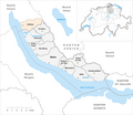
The Miles district is a district in the canton of Zurich in Switzerland and includes the right bank of Lake Zurich - the so-called Gold Coast - and the southern flank of the Pfannenstiel . The municipality of Zollikon only changed to the Meilen district on January 1, 1986, before it belonged to the Zurich district .
Political communities
| coat of arms | Postcode | Parish name | Population (December 31, 2018) |
Area in km² |
Inhabitants per km² |
|---|---|---|---|---|---|
|
|
8703 | Erlenbach (ZH) | 5618 | 2.89 | 1944 |
|
|
8704 | Herrliberg | 6391 | 8.99 | 711 |
|
|
8634 | Hombrechtikon | 8757 | 12.18 | 719 |
|
|
8700 | Küsnacht (ZH) | 14,397 | 12.36 | 1165 |
|
|
8708 | Männedorf | 11'243 | 4.77 | 2357 |
|
|
8706 | miles | 14'220 | 11.94 | 1191 |
|
|
8618 | Oetwil am See | 4817 | 6.11 | 788 |
|
|
8712 | Stäfa | 14'497 | 8.59 | 1688 |
|
|
8707 | Uetikon am See | 6176 | 3.46 | 1785 |
|
|
8702 | Zollikon | 13,012 | 7.85 | 1658 |
|
|
8126 | Zumikon | 5284 | 5.48 | 964 |
| Total (11) | 104,412 | 84.62 | 1234 | ||
Changes in the community

Municipalities until 1976
Municipalities until 1985


- 1977: Change of name Uetikon → Uetikon am See
- 1986: Change of district Zollikon from Zurich district → Meilen district
Civil parishes
There are no more civil parishes .
Localities
Web links
Commons : District Meilen - Collection of pictures, videos and audio files
- Heinrich Boxler: miles (Vogtei). In: Historical Lexicon of Switzerland .
Individual evidence
- ↑ Permanent and non-permanent resident population by year, canton, district, municipality, population type and gender (permanent resident population). In: bfs. admin.ch . Federal Statistical Office (FSO), August 31, 2019, accessed on December 22, 2019 .
- ↑ Federal Statistical Office Generalized Limits 2020.
Districts of the Canton of Zurich