
Herrliberg
| Herrliberg | |
|---|---|
 |
|
| State : |
|
| Canton : |
|
| District : | miles |
| BFS no. : | 0152 |
| Postal code : | 8704 |
| UN / LOCODE : | CH HBG |
| Coordinates : | 688 989 / 238012 |
| Height : | 464 m above sea level M. |
| Height range : | 406–848 m above sea level M. |
| Area : | 8.99 km² |
| Residents: | 6391 (December 31, 2018) |
| Population density : | 711 inhabitants per km² |
|
Proportion of foreigners : (residents without citizenship ) |
21.8% (December 31, 2018) |
| Mayor : | Gaudenz Schwitter (FDP) |
| Website: | www.herrliberg.ch |
 Reformed church and pier of the ZSG |
|
| Location of the municipality | |
  |
|
Herrliberg is a municipality in Switzerland . It is located on the lower right bank of Lake Zurich on the so-called Gold Coast in the Meilen district in the canton of Zurich . The hamlet of Wetzwil is also part of the community .
geography
The municipality has an area of 897 hectares , 56% of which is used for agriculture, 24% is covered with forest, 16% is settlements and 4% is traffic areas.
history


Herrliberg is first mentioned in 1153–55 as Hardiperc , and in the middle of the 15th century the community was called Härliberg .
coat of arms
- Three black double yokes in gold on top of each other.
The coat of arms of the Herrliberg community was first mentioned in Gerold Edlibach's coat of arms book, which appeared at the end of the 15th century. The double yokes refer to the formerly important peasantry in Herrliberg . In the middle of the 19th century, as a result of the growing importance of viticulture, a coat of arms with a bunch of grapes replaced the traditional municipal coat of arms , which was then used again from 1934.
Demographics
population
| year | 1634 | 1760 | 1850 | 1888 | 1900 | 1950 | 2000 | 2005 | 2010 | 2018 |
| population | 512 | 979 | 1144 | 964 | 985 | 2298 | 5499 | 5585 | 6069 | 6391 |
Age groups
Table with percentage of inhabitants per age group
| 0 to 19 | 20 to 64 | over 64 |
|---|---|---|
| 21.4% | 62.6% | 16% |
languages
Table showing the percentage of the population with the respective language as their mother tongue
| German | English | French |
|---|---|---|
| 89.2% | 2.9% | 2.2% |
The proportion of foreigners is 22.4%. Denomination: 42.2% Protestant Reformed , 26.9% Roman Catholic , 30.9% other or no denominational affiliation (status: 2010).
Buildings and sights
Churches
There are three churches in Herrliberg:
- The Reformed Church in Herrliberg goes back to a medieval building that was first mentioned in a document in 1370.
- The reformed church in Wetzwil ob Herrliberg was consecrated to St. Bartholomew in the Middle Ages. Wall paintings from the first quarter of the 15th century were whitewashed after the Reformation, but were exposed again in 1930. They show the protective cloak Madonna with angels to the side and below the adoration by the Magi .
- The Catholic Church of St. Mary dates back to 1956 and was built by architects Walter Rieger and Ferdinand Pfammatter in the style of the French concrete Gothic. It contains a monumental glass painting by the artist Hans Stocker .
traffic
The distance to Zurich main station is 13 kilometers.
The right bank of the Zürichseebahn runs through Herrliberg with the S6 and S16 lines of the Zürich S-Bahn . There is a 15-minute cycle from 6 a.m. to 9 p.m., otherwise a 30-minute cycle. The S6 continues from Zurich to Uetikon, while the S16 (mostly) ends in Herrliberg. The Herrliberg-Feldmeilen train station is just outside the municipality in the municipality of Meilen.
There are also motor ships operated by the Lake Zurich Shipping Company (approximately every two hours in summer, only one connection in winter).
Plowstone

Above Herrliberg stands the Pflugstein, which is the largest boulder in the canton with around 1000 m³ of visible rock . It lies at an altitude of 560 meters, consists of reddish melaphyre and was carried here around 15,000 years ago during the last Ice Age from the Kärpf region of the Glarus Alps through the Linth glacier .
The linden tree next to the boulder was planted by Erich Graf von Betzel-Sternau in 1832 as a souvenir of the Ustertag . On August 1, 1939, the plowstone was placed under protection and thus avoided a planned demolition. The linden tree is also under protection. The border between the municipalities of Herrliberg and Erlenbach runs between the Pflugstein restaurant just below the stone and the stone.
According to a legend, the stone was created where two lovers were struck by lightning under the curse of their strict father and sank into the earth. At midnight, the lovers should sometimes stride tightly embraced around the stone on quiet nights and quietly cry out their laments into the night. That is why the stone is sometimes called the curse stone.
Sports
The FC Herrliberg is the Football Association of Herrliberg. Yann Sommer played in this as a little boy.
gallery

Herrliberg-Wetzwil
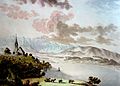
Herrliberg on May 21, 1786, watercolor by Hans Conrad Escher von der Linth
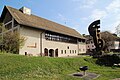
Vogtei Herrliberg - former tithe barn

pre-Christian bowl stone from Wetzwil

reformed Church


Personalities
- David Ammann (1855–1923), founder of the Mazdaznan movement in Europe
- Hans Kasser (1907–1978), graphic artist
- Walter Stutzer (1923–2009), journalist
- Carmen Pulver (* 1995), soccer player
resident:
- Peter Uebersax (1925–2011), editor-in-chief of Blick
- Nikolaus Senn (1926–2014), bank manager, honorary president of UBS
- Christoph Blocher (* 1940), industrialist, politician (SVP), Federal Councilor
- Jürg Marquard (* 1945), publisher
- Peter Kurer (* 1949), manager and business lawyer
- Roland Leutwiler (* 1962), finance manager, entrepreneur and sports official
- Tidjane Thiam (* 1962), manager and former minister, former CEO Credit Suisse
- Christoph Tonini (* 1969), manager, former managing director of Tamedia
- Steve Guerdat (* 1982), show jumper, Olympic champion 2012
acted on site:
- Charlotte Weiss (1870–1961), painter
- Margarethe Faas-Hardegger (1882–1963), socialist and women's rights activist
- Carl Fischer (1888–1987), sculptor
literature
- Hermann Fietz: The art monuments of the canton of Zurich, Volume II: The districts of Bülach, Dielsdorf, Hinwil, Horgen and Meilen. (= Art Monuments of Switzerland. Volume 15). Edited by the Society for Swiss Art History GSK. Bern 1943. DNB 365803049 .
Web links
- Official website of the Herrliberg community
- Traffic and beautification association of the municipality of Herrliberg
- Statistical data for the municipality of Herrliberg
- Martin Illi : Herrliberg. In: Historical Lexicon of Switzerland .
Individual evidence
- ↑ Permanent and non-permanent resident population by year, canton, district, municipality, population type and gender (permanent resident population). In: bfs. admin.ch . Federal Statistical Office (FSO), August 31, 2019, accessed on December 22, 2019 .
- ↑ Data on the resident population by home, gender and age (community profile). Statistical Office of the Canton of Zurich, accessed on December 22, 2019 .
- ↑ numbers. Population. as of December 31, 2019. Herrliberg community, accessed on August 24, 2020 .
- ^ Hans G. Wägli: Swiss rail network and CH + rail profiles. 2010, ISBN 978-3-909111-74-9 .
- ↑ http://www.vvherrliberg.ch/rundgang/punkt-68.html Verschönerungsverein Herrliberg
- ↑ Archived copy ( memento of April 15, 2017 in the Internet Archive ) Steinkreis.ch>