
Goldbach ZH

Goldbach is a part of the village of Küsnacht in the canton of Zurich in Switzerland . Goldbach is located on Lake Zurich in the north of the village of Küsnacht and borders Zollikon .
history


The oldest documents about Goldbach come from the year 1224. Between 1320 and 1333 the village came into the possession of Götz I. Mülner as an independent municipality together with Zollikon and Küsnacht as an imperial fief . In 1384 Götz III sold. Mülner Küsnacht and Goldbach for 400 guilders to the city of Zurich .
Even if Goldbach retained a certain degree of independence, this meant the end of the old Goldbach community. The village belonged together with Küsnacht to the Obervogtei Küsnacht, which was administered by two senior bailiffs belonging to the Zurich council. However, the residents were still allowed to hold meetings to discuss village business. In 1417 32 people were taxed in Goldbach, in 1450 there were 49 of them, who were distributed over 19 homes. The Lochmanns were a long-established family, of whom around 1500 five representatives were incorporated into city citizenship.

Belonging to the Vogtei Küsnacht existed until 1798, then Zurich declared the equality of town and country and the uniform constitution of the Helvetic Republic replaced the old order.
Most of the inhabitants of old Goldbach were engaged in viticulture; Along the old road down to the lake and uphill to the forest, the slopes were covered with vines. In 1844, 14 trotters were in use in Goldbach . The last trot of Goldbach belonged to Jean Leemann. It was in use until 1925, when it was canceled.
In 1909, after the construction of the Seestrasse and the railway line on the right bank, almost the entire vineyard area was built over within a few decades. Goldbach grew together with Küsnacht in the south and Zollikon in the north. Some of the old houses have been preserved along Goldbacherstrasse and Boglerenstrasse.
Surname
Goldbach was named after the stream of the same name, which flowed into the lake along today's Goldbacherstrasse at the high chimney of Terlinden Textilpflege . Today nothing can be seen of it, it was probably overturned or filled in at the beginning of the 20th century when the construction zone was extended to almost the entire slope area. Alemannic settlers are said to have given the small body of water its name in the early Middle Ages.
The name Goldbach appears in the late Middle Ages as Goltbach , Goltpach or Golpach ; the current spelling appears for the first time around the middle of the 15th century. It is not known where the stream got its name from. One possible explanation is that it is derived from the "Goldenen Halde" (today Goldhaldenstrasse) in Zollikon, which Johannes Stumpf mentions in his chronicle. The name of the "Golden Halde" refers to the vines that shine golden in the evening sun. It is not known that gold was ever found in the brook.
Goldbacherhof
The Goldbacherhof at Seestrasse 29 was probably the most representative building in Goldbach; the property was first mentioned in a document in 1527. In 1658, Junker Gerold Meyer von Knonau, court lord of Weiningen ZH , bought the property that was then directly on the lake. Between 1666 and 1671 he built the Goldbacherhof who opposes the tradition traufständig was created. The family owned the building until 1775. From 1925 to 1948 the Goldbacherhof was owned by the building contractor Ernst Göhner , who had a paneled state room built in the neo-renaissance style on the ground floor. The ballroom on the ground floor is decorated with wallpaper from the first half of the 18th century depicting hunting and landscape scenes. In 1838 the bank in front of the house was filled in for the construction of the Seestrasse.

Goldbacherhof around 1717, from the lake; before the construction of the Seestrasse.

Goldbacherhof 2013. The roof hatch was built in 1924.

Chapel on Risseren
1410 barter transactions appear in a document: The Goldbacherstrasse exchanged one them on Zolliker ground against one above the Goldbacherstrasse Allmend-lying area, "which is called Risseren" on which they built a small church, the Holy piece of property belonging Anna and Joseph was ordained . It is conceivable that some of the wealthy Goldbachers who had become city citizens made the construction possible with generous donations. In the year book of the Küsnacht church, donations and masses are mentioned several times between 1500 and 1510; so z. Example on January 22, 1500: "Jakob Müller and Gret Müllerin and Eberli Müller 1 pound Geltz uf Rießeren".
The whitewashed chapel stood west of the Rumensee on a small hill. Presumably because of its white color, it was also called the Wisskirchlein . Their dimensions were around 6 by 13 meters. Around the building there was an enclosure wall at a distance of 20 to 40 meters, which surrounded an area of perhaps 2000 m 2 . No traces of a cemetery were found. Since the area was not forested at that time, one had a wide view of the village, lake and mountains. The exchange deed mentions fences that need to be maintained and a ban on planting vines.
It is not known when the church was abandoned; this probably happened at the beginning of the Reformation . Usable building material was probably used by farmers as building material, the rest fell apart. Today a forest path leads right through the site of the former chapel. The course of the foundation walls can still be seen.

Location map
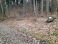
Foundation walls of the old church
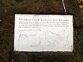
Information board


Digs
Until 1913 only a depression in the forest floor reminded of the former chapel. The hole was called the "treasure hunt hole" and there were rumors of hidden treasures and underground passages. The legends “The treasure in Isertkirchlein” and “The monster at the St. Anna chapel” remind of these eerie stories.
In 1913 an existing forest path to Wisskirchlistrasse was expanded, a forest road with a natural surface. The foundations of the old chapel were still in good condition. To compensate for the slope of the street, the western corner of the walls and a piece of the choir foundation walls were broken away. It turned out that the remains of the wall consisted of large boulders. The masonry was up to a meter thick and interspersed with massive fir roots that had been felled three years earlier. Inside, the well-preserved floor covering made of three centimeters thick white lime mortar was exposed. The floor of the small choir, which was raised by 30 centimeters, consisted of hewn tufa slabs. Stones and rubble were used to build the forest road.
In 1957, at the instigation of the Küsnacht Improvement Association, further excavations were carried out. The foundation walls were uncovered and plans of the building were drawn. In 1979 the trees around the ruins were felled. The walls were again exposed and secured. A bench was set up and a plaque on a boulder commemorates Goldbach's old church.
Isis legend
In reports from around 1800 and on old plans - including on the game map from 1848 - the church ruins are referred to as "Isis-Kirchli". The mysterious-sounding name Isis , however, may have come from the Alemanni Risso, who gave the area its name (which has now disappeared). The Rain of the Risso became Risseren and Rissernrain and in the course of time it became Isis.
literature
- Walter Bruppacher: The chapel on Risseren, the church of the old parish of Goldbach , in: Küsnachter Jahresblätter 1964, pp. 33–37
- Reinhard Braun: Goldbach am Zürichsee and the dyeing trade , Tschopp, Zürich 1930
- Küsnacht am Zürichsee , Swiss Art Guide No. 606/607, Bern 1997
Web links
Individual evidence
- ↑ Küsnachter Jahresblätter 1971, p. 56
- ↑ Küsnachter Jahresblätter 181, p. 10
- ↑ Küsnachter Jahresblätter 1980, p. 11
- ^ Küsnacht on Lake Zurich. Swiss Art Guide, No. 606/607. Bern 1997, p. 42
- ^ Küsnacht on Lake Zurich. Swiss Art Guide, No. 606/607. Bern 1997, p. 43.
Coordinates: 47 ° 20 ' N , 8 ° 35' E ; CH1903: 686059 / 242599