Gunnison County
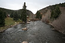
 Taylor Hall |
|
| administration | |
|---|---|
| US state : | Colorado |
| Administrative headquarters : | Gunnison |
| Foundation : | 1877 |
| Made up from: | Lake County |
| Demographics | |
| Residents : | 15,324 (2010) |
| Population density : | 1.8 inhabitants / km 2 |
| geography | |
| Total area : | 8443 km² |
| Water surface : | 54 km² |
| map | |
| Website : www.gunnisoncounty.org | |
The Gunnison County [ gʌnɪsən ] is a county in Colorado . The county seat is Gunnison .
geography

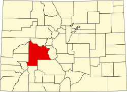
The county is located in the central to western part of the US state Colorado . It encompasses a mountainous landscape of the Rocky Mountains west of the Arkansas River and southeast of the Colorado River and is enclosed clockwise by the Counties Pitkin (north), Chaffee , Saguache , Hinsdale , Ouray , Montrose , Delta and Mesa .
Gunnison County is completely traversed by the Rocky Mountain ranges. The highest peaks are in the Sawatch Range and the Elk Mountains , which form the northeastern borderline and are part of the San Isabel and White River National Forests and the Maroon Bells-Snowmass Game Reserve . The western border, on the other hand, is not a natural one; it leads in a straight line through the West Elk Mountains , whose densely forested mountain ranges reach into the center of Gunnison and, like most of the interior of the county, belong to the Gunnison National Forest . West Elk is separated from the San Juan Mountains to the south by the Gunnison River and Colorado's largest lake, the Blue Mesa Reservoir .
The Blue Mesa Reservoir is part of the Curecanti National Recreation Area .
history
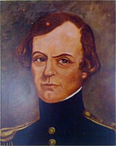
Gunnison County, named after the discoverer John Williams Gunnison , emerged from most of Lake County in 1877 .
The eastern part of Gunnison has remained in its original boundaries to this day, while the western part - which reached as far as the state border with Utah - was ceded to the newly founded counties of Mesa , Delta and Montrose in 1883 .
Demographic data
| growth of population | |||
|---|---|---|---|
| Census | Residents | ± in% | |
| 1880 | 8235 | - | |
| 1890 | 4359 | -47.1% | |
| 1900 | 5331 | 22.3% | |
| 1910 | 5897 | 10.6% | |
| 1920 | 5590 | -5.2% | |
| 1930 | 5527 | -1.1% | |
| 1940 | 6192 | 12% | |
| 1950 | 5716 | -7.7% | |
| 1960 | 5477 | -4.2% | |
| 1970 | 7578 | 38.4% | |
| 1980 | 10,689 | 41.1% | |
| 1990 | 10,273 | -3.9% | |
| 2000 | 13,956 | 35.9% | |
| 2010 | 15,324 | 9.8% | |
| Before 1900
1900–1990 2000 2010 |
|||


As of the 2000 census , the county had 13,956 people. There were 5,649 households and 2,965 families. The population density was 2 people per square kilometer. The racial the population was composed of 95.08 percent white, 0.49 percent African American, 0.70 percent Native American, 0.54 percent Asian, 0.04 percent of residents from the Pacific island area and 1.44 percent from other ethnic groups Groups; 1.72 percent were descended from two or more races. Hispanic or Latino of any race was 5.02 percent of the total population.
Of the 5649 households, 24.1 percent had children and adolescents under the age of 18 living with them. 44.2 percent were married couples living together, 5.4 percent were single mothers. 47.5 percent were not families. 27.2 percent were single households and 4.6 percent had people aged 65 or over. The average household size was 2.30 and the average family size was 2.84 people.
For the entire county, the population was composed of 17.9 percent of residents under 18 years of age, 21.1 percent between 18 and 24 years of age, 32.9 percent between 25 and 44 years of age, 21.2 percent between 45 and 64 years of age 6.9 percent were 65 years of age or over. The average age was 30 years. For every 100 females there were 118.3 males, and for every 100 females aged 18 and over there were 120.9 males.
The median income for a household in the county is $ 36,916 , and the median income for a family is $ 51,950. Males had a median income of $ 30,885 and women $ 25,000. The per capita income was $ 21,407. 15.0 percent of the population and 6.0 percent of families are below the poverty line. This included 9.4 percent of the population under the age of 18 and 7.2 percent of the population aged 65 and over.
Places in Gunnison County
Rivers
Protected areas
Individual evidence
- ↑ GNIS-ID: 198141. Retrieved on February 22, 2011 (English).
- ↑ US Census Bureau - Census of Population and Housing . Retrieved March 15, 2011
- ↑ Extract from Census.gov . Retrieved February 28, 2011
- ↑ Excerpt from factfinder.census.gov.Retrieved February 28, 2011
- ↑ Excerpt from census.gov ( memento of the original from July 11, 2011 on WebCite ) Info: The archive link was inserted automatically and has not yet been checked. Please check the original and archive link according to the instructions and then remove this notice. Retrieved March 31, 2012
Web links
- National recreation area Curecanti ( Memento from June 24, 2006 in the Internet Archive ) (German, English)
Coordinates: 38 ° 40 ′ N , 107 ° 1 ′ W


