
Støren: Difference between revisions
No edit summary |
expand hatnote |
||
| (17 intermediate revisions by 13 users not shown) | |||
| Line 1: | Line 1: | ||
{{about|the village in Midtre Gauldal, Norway|the former municipality in Trøndelag, Norway|Støren (municipality)||Storen (disambiguation)}} |
|||
{{Infobox settlement |
|||
|name = Støren herad |
|||
|settlement_type = [[List of former municipalities of Norway|Former Municipality]] |
|||
|image_skyline = StorenKirke.JPG |
|||
|image_caption = View of the local church |
|||
| ⚫ | |||
|seat = Støren |
|||
|blank_name = Created as |
|||
|blank_info = [[Formannskapsdistrikt]] in 1838 |
|||
|blank1_name = Merged into |
|||
|blank1_info = [[Midtre Gauldal]] in 1964 |
|||
|area_total_km2 = |
|||
|area_footnotes = <ref name="snl" /> |
|||
|subdivision_type3 = Municipality ID |
|||
|subdivision_name3 = [[ISO 3166-2:NO|NO-1648]] |
|||
}} |
|||
{{Infobox settlement |
{{Infobox settlement |
||
|official_name = Støren |
|official_name = Støren |
||
| Line 23: | Line 8: | ||
|image_skyline = |
|image_skyline = |
||
|image_caption = View of the village |
|image_caption = View of the village |
||
|pushpin_map = |
|pushpin_map = Trøndelag#Norway |
||
|pushpin_label_position = |
|pushpin_label_position = top |
||
|pushpin_mapsize = |
|pushpin_mapsize = |
||
|pushpin_map_caption = Location |
|pushpin_map_caption = Location of the village |
||
|coordinates_display = inline,title |
|||
|coordinates_region = NO |
|||
|coordinates_type = type:city |
|||
|subdivision_type = Country |
|subdivision_type = Country |
||
|subdivision_name = [[Norway]] |
|subdivision_name = [[Norway]] |
||
|subdivision_type1 = [[List of regions of Norway|Region]] |
|subdivision_type1 = [[List of regions of Norway|Region]] |
||
|subdivision_name1 = [[ |
|subdivision_name1 = [[Central Norway]] |
||
|subdivision_type2 = [[Counties of Norway|County]] |
|subdivision_type2 = [[Counties of Norway|County]] |
||
|subdivision_name2 = [[ |
|subdivision_name2 = [[Trøndelag]] |
||
|subdivision_type3 = [[Districts of Norway|District]] |
|subdivision_type3 = [[Districts of Norway|District]] |
||
|subdivision_name3 = [[Gauldalen]] |
|subdivision_name3 = [[Gauldalen]] |
||
|subdivision_type4 = [[List of municipalities of Norway|Municipality]] |
|subdivision_type4 = [[List of municipalities of Norway|Municipality]] |
||
| Line 45: | Line 27: | ||
|utc_offset1_DST = +02:00 |
|utc_offset1_DST = +02:00 |
||
|area_footnotes = <ref name="ssb" /> |
|area_footnotes = <ref name="ssb" /> |
||
|area_total_km2 = 2. |
|area_total_km2 = 2.43 |
||
|population_as_of = |
|population_as_of = 2018 |
||
|population_footnotes = <ref name="ssb" /> |
|population_footnotes = <ref name="ssb" /> |
||
|population_total = |
|population_total = 2,276 |
||
|population_density_km2 = |
|population_density_km2 = 937 |
||
|postal_code_type = Post Code |
|postal_code_type = Post Code |
||
|postal_code = 7290 Støren |
|postal_code = 7290 Støren |
||
|coordinates = {{coord|63.0391|10.2851|region:NO_type:city|display=inline,title}} |
|||
|elevation_m = 100 |
|||
| ⚫ | |||
|elevation_footnotes = <ref>{{cite web|url= |
|elevation_footnotes = <ref>{{cite web|title=Støren, Midtre Gauldal (Trøndelag)|url=https://www.yr.no/place/Norway/Tr%C3%B8ndelag/Midtre_Gauldal/St%C3%B8ren/|publisher=[[yr.no]]|accessdate=2018-01-21}}</ref>}} |
||
|latd = 63 |latm = 02 |lats = 20 |latNS = N |
|||
|longd= 10 |longm= 17 |longs= 06 |longEW= E |
|||
}} |
|||
{{Audio|Stoeren.ogg|'''Støren'''}} is the [[administrative centre]] of [[Midtre Gauldal]] municipality in [[Trøndelag]] county, [[Norway]]. The village is located in the [[Gauldalen]] valley at the [[confluence]] of the rivers [[Gaula (Trøndelag)|Gaula]] and ''Sokna''. Støren is located on the [[European route E06]] highway, about {{convert|50|km}} south of the city of [[Trondheim]]. The junction between the [[Dovrebanen]] and [[Rørosbanen]] railway lines is at [[Støren Station]] in the northern part of the village. [[Støren Church]], a school, government services, and commercial and industrial sites are all located in the village.<ref name="snl">{{cite encyclopedia|url=https://snl.no/St%C3%B8ren_-_tettsted|title=Støren – tettsted|editor-first=Morten|editor-last=Haugen|accessdate=2018-01-15|date=2017-08-30|encyclopedia=[[Store norske leksikon]]|publisher=[[Kunnskapsforlaget]]|language=Norwegian}}</ref> |
|||
{{Audio|Stoeren.ogg|'''Støren'''}} is a [[List of former municipalities of Norway|former municipality]] in [[Sør-Trøndelag]] county, Norway. The municipality is located in the north-central part of the present-day municipality of [[Midtre Gauldal]]. The municipal center of Støren was the village of Støren, where [[Støren Church]] is located. |
|||
The {{convert|2.43|km2|acre|adj=on}} village has a population (2018) of 2,276 and a [[population density]] of {{convert|937|PD/km2}}.<ref name="ssb">{{cite web|title=Urban settlements. Population and area, by municipality|authorlink=Statistics Norway|author=Statistisk sentralbyrå|url=https://www.ssb.no/en/befolkning/statistikker/beftett/aar |date=1 January 2018}}</ref> |
|||
==History== |
|||
Støren was established as a municipality on 1 January 1838 (see [[formannskapsdistrikt]]). In 1841, the large municipality of Støren was divided into three municipalities: [[Horg]] in the north, Støren in the east, and [[Soknedal]] in the west. The new, smaller Støren had a population of 2,312. In 1879, the southern part of Støren was separated to form the new municipality of [[Budal]]. This left Støren with 1,840 residents. On 1 January 1964, the municipalities of [[Budal]], [[Soknedal]], [[Singsås]], and Støren were merged to form the new municipality of [[Midtre Gauldal]]. Prior to the merger, Støren had a population of 2,296.<ref>{{cite web|first=Dag|last=Jukvam|publisher=[[Statistics Norway|Statistisk sentralbyrå]]|title=Historisk oversikt over endringer i kommune- og fylkesinndelingen|year=1999|url=http://www.ssb.no/emner/00/90/rapp_9913/rapp_9913.pdf|language=Norwegian}}</ref> |
|||
==Name== |
==Name== |
||
The parish |
The village (and parish/municipality) was named after the old ''Støren'' farm ({{lang-non|Staurin}}), since the first [[Støren Church]] was built there. The first element is ''staurr''' which means "pointed pole" and the last element is ''vin'' which means "[[meadow]]" or "[[pasture]]". The word ''staurr'' is probably referring to the pointed [[headland]] on which the church is located. The two rivers that form this headland are the [[Gaula (Trøndelag)|Gaula]] and ''Sokna''.<ref>{{cite book|title=Norske gaardnavne: Søndre Trondhjems amt|edition=14|authorlink=Oluf Rygh|last=Rygh|first=Oluf|publisher=W. C. Fabritius & sønners bogtrikkeri|year=1901|location=Kristiania, Norge|pages=239|url=https://books.google.com/books?id=AGxBAAAAIAAJ|language=Norwegian}}</ref> |
||
==Media gallery== |
|||
<gallery mode="packed"> |
|||
Støren sentrum (01).JPG|Village centre |
|||
Størenhallen (3).JPG|Størenhallen |
|||
Korsen på Støren (3).JPG|School in Støren |
|||
Støren Hotel (01).JPG|Støren hotel |
|||
StorenKirke.JPG|[[Støren Church]] |
|||
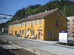
Storen stasjon Rorosbanen 2008.JPG|[[Støren Station]] |
|||
</gallery> |
|||
==Popular culture== |
==Popular culture== |
||
| Line 74: | Line 61: | ||
{{reflist}} |
{{reflist}} |
||
{{authority control}} |
|||
| ⚫ | |||
Støren er kjent for sin fine natur. |
|||
| ⚫ | |||
[[Category:Midtre Gauldal]] |
[[Category:Midtre Gauldal]] |
||
[[Category: |
[[Category:Villages in Trøndelag]] |
||
[[Category:Villages in Sør-Trøndelag]] |
|||
[[fr:Støren]] |
|||
[[nl:Støren]] |
|||
[[no:Støren]] |
|||
[[nn:Støren]] |
|||
[[pt:Støren]] |
|||
[[fi:Støren]] |
|||
[[sv:Støren]] |
|||
[[zh:斯特倫]] |
|||
Latest revision as of 16:21, 10 May 2020
Støren | |
|---|---|
Village | |
 Støren Location of the village  Støren Støren (Norway) | |
| Coordinates: 63°02′21″N 10°17′06″E / 63.0391°N 10.2851°E | |
| Country | Norway |
| Region | Central Norway |
| County | Trøndelag |
| District | Gauldalen |
| Municipality | Midtre Gauldal |
| Area | |
| • Total | 2.43 km2 (0.94 sq mi) |
| Elevation | 91 m (299 ft) |
| Population (2018)[1] | |
| • Total | 2,276 |
| • Density | 937/km2 (2,430/sq mi) |
| Time zone | UTC+01:00 (CET) |
| • Summer (DST) | UTC+02:00 (CEST) |
| Post Code | 7290 Støren |
is the administrative centre of Midtre Gauldal municipality in Trøndelag county, Norway. The village is located in the Gauldalen valley at the confluence of the rivers Gaula and Sokna. Støren is located on the European route E06 highway, about 50 kilometres (31 mi) south of the city of Trondheim. The junction between the Dovrebanen and Rørosbanen railway lines is at Støren Station in the northern part of the village. Støren Church, a school, government services, and commercial and industrial sites are all located in the village.[3]
The 2.43-square-kilometre (600-acre) village has a population (2018) of 2,276 and a population density of 937 inhabitants per square kilometre (2,430/sq mi).[1]
Name[edit]
The village (and parish/municipality) was named after the old Støren farm (Old Norse: Staurin), since the first Støren Church was built there. The first element is staurr' which means "pointed pole" and the last element is vin which means "meadow" or "pasture". The word staurr is probably referring to the pointed headland on which the church is located. The two rivers that form this headland are the Gaula and Sokna.[4]
Media gallery[edit]
-
 Village centre
 -
 Størenhallen
 -
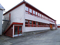 School in Støren
 -
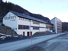 Støren hotel
 -

-
.JPG)
.JPG)
.JPG)
.JPG)


Popular culture[edit]
The Norwegian movie Bør Børson made Støren famous. In this movie, the protagonist, Bør Børson, is visiting a fictional Støren bakery.
References[edit]
- ^ a b c Statistisk sentralbyrå (1 January 2018). "Urban settlements. Population and area, by municipality".
- ^ "Støren, Midtre Gauldal (Trøndelag)". yr.no. Retrieved 2018-01-21.
- ^ Haugen, Morten, ed. (2017-08-30). "Støren – tettsted". Store norske leksikon (in Norwegian). Kunnskapsforlaget. Retrieved 2018-01-15.
- ^ Rygh, Oluf (1901). Norske gaardnavne: Søndre Trondhjems amt (in Norwegian) (14 ed.). Kristiania, Norge: W. C. Fabritius & sønners bogtrikkeri. p. 239.