
Mount Scopus: Difference between revisions
Citation bot (talk | contribs) Altered template type. Added date. | Use this bot. Report bugs. | Suggested by Superegz | Category:Former exclaves | #UCB_Category 44/44 |
|||
| (373 intermediate revisions by more than 100 users not shown) | |||
| Line 1: | Line 1: | ||
{{Short description|Mountain in northeast Jerusalem}} |
|||
{{refimprove|date=February 2008}} |
|||
{{For|the school in Australia|Mount Scopus Memorial College}} |
|||
[[Image:Skopusberg mit Universitaet.jpg|thumb|right|300px|The Hebrew University campus and tower on Mount Scopus from the south]] |
|||
{{Use mdy dates|date=June 2013}} |
|||
'''Mount Scopus''' ([[Hebrew language|Hebrew]] '''הַר הַצּוֹפִים''' ('''Har HaTzofim'''), [[Arabic language|Arabic]] ''جبل المشارف'' ''{{unicode|Ǧabal al-Mašārif}}'', ''جبل المشهد'' ''{{unicode|Ǧabal al-Mašhad}}'', ''جبل'' ''الصوانة'') is a mountain {{Fact|date=June 2008}}(elevation: 834 meters above sea level) in northeast [[Jerusalem]], [[Israel]]. Overlooking [[Jerusalem]], Mount Scopus has been strategically important for the defense of the city since antiquity. The [[Roman Legion]] camped there in 70 CE, and the [[Crusaders]] in 1099. In the [[1948 Arab-Israeli War]], parts of Mount Scopus became an Israeli [[exclave]] within [[Jordan|Jordanian]] territory until the [[Six-Day War]] in 1967. Today, Mount Scopus lies within the municipal boundaries of the [[Jerusalem|city of Jerusalem]]. |
|||
{{Infobox mountain |
|||
| name = Mount Scopus |
|||
| other_name = {{Script/Hebrew|הַר הַצּוֹפִים}} ''{{lang|he-Latn|Har HaTsofim}}''<br/>{{lang|ar|جبل المشارف}} ''{{lang|ar-Latn|Ǧabal al-Mašārif}}'' |
|||
| photo = MountScopusDec032022 03.jpg |
|||
| photo_caption = The [[Hebrew University of Jerusalem|Hebrew University]] campus and tower on Mount Scopus from the north |
|||
| elevation_m = 826 |
|||
| elevation_ref= |
|||
| location = [[Jerusalem]] |
|||
| map= |
|||
| map_alt= |
|||
| map_caption= |
|||
| map_size= |
|||
| coordinates = {{coord|31|47|33|N|35|14|39|E|type:mountain_scale:100000|format=dms|display=inline,title}} |
|||
| range = [[Judaean Mountains|Judaean]] |
|||
| topo= |
|||
}} |
|||
[[File:MountScopusNov102022.jpg|thumb|Mt. Scopus, Jerusalem|alt=Mt. Scopus, Jerusalem|290x290px]] |
|||
[[File:HadassahUniversityHospitalMtScopusNov102022.jpg|thumb|Hadassah University Hospital, Mt. Scopus, Jerusalem|alt=Hadassah University Hospital, Mt. Scopus, Jerusalem|border|290x290px]] |
|||
{{Jerusalem large}} |
|||
'''Mount Scopus''' ({{lang-he|הַר הַצּוֹפִים}} ''{{lang|he-Latn|Har HaTsofim}}'', "Mount of the Watchmen/ Sentinels"; {{lang-ar|جبل المشارف}} ''{{lang|ar-Latn|Ǧabal al-Mašārif}}'', lit. "Mount Lookout", or {{lang|ar|جبل المشهد}} ''{{lang|ar-Latn|Ǧabal al-Mašhad}}'' "Mount of the Scene/Burial Site", or {{lang|ar|جبل الصوانة}} "Mount [[Syenite]]") is a mountain (elevation: {{convert|826|meters}} above sea level) in northeast [[Jerusalem]]. |
|||
Between the [[1948 Arab–Israeli War]] and the [[Six-Day War]] in 1967, the peak of Mount Scopus with the Hebrew University campus and Hadassah Hospital was a UN-protected [[exclave]] of [[Israel]] within [[Jordan]]. Today, Mount Scopus lies within the municipal boundaries of the city of Jerusalem. |
|||
==Jordan-Israel armistice agreement== |
|||
After the [[ceasefire]] agreement of November 30, 1948, which established the division of East and West Jerusalem, Israel was alloted control of the western part of the city while Jordan controlled the east. Several demilitarized "[[no man's land]]" zones were established along the border, one of them Mount Scopus.<ref name="Mideastweb">[http://www.mideastweb.org/isrjorarmistice1949.htm Mideast Web. org.]</ref> |
|||
==Name and identification== |
|||
Article VIII of the [[1949 Armistice Agreements|armistice agreement]] signed by Moshe Dayan on behalf of the Government of Israel and [[Jordan]] in April 1949,<ref name="AA">[http://domino.un.org/unispal.nsf/9a798adbf322aff38525617b006d88d7/f03d55e48f77ab698525643b00608d34!OpenDocument UN Doc S/1302/Rev.1 of 3 April 1949] Hashemite Jordanian Kingdom Israel Armistice Agreement</ref> called for ways to seek the resumption of "the normal functioning of the cultural and humanitarian institutions on Mount Scopus and free access thereto; free access to the Holy Places and cultural institutions and use of the cemetery on the Mount of Olives; resumption of operation of the [[Latrun]] pumping station; provision of electricity for the [[Old City]]; and resumption of operation of the railroad to Jerusalem."<ref name="Mideastweb"/> |
|||
The ridge of mountains east of ancient as well as modern Jerusalem offers the best views of the city, which it dominates. Since the main part of the ridge bears the name [[Mount of Olives]], the name "lookout" was reserved for this peak to the northeast of the ancient city. Its name in many languages (Hebrew, Arabic, Greek and Latin) means "lookout." Scopus is a Latinisation of the Greek word for "watcher", ''skopos'', the same as in "telescope" (''tele-'' meaning far and ''skopos'' – watcher). Adding to the multi-layered meaning of the name, it is also said that in times in which the city's Roman or [[Byzantine]] authorities prohibited Jews from entering Jerusalem, they used to come and look at their former capital from this vantage point.{{citation needed|date=February 2021}} |
|||
===Local Area Commanders agreements=== |
|||
The Mount Scopus Agreement signed on July 7, 1948 regulated the demilitarised zone around Mount Scopus and authorized the Chief of Staff of the United Nations Truce Supervision Organization and his representative to settle disputes between the Israelis and Jordanians. The Jewish-owned property was surrounded by a fence, but clashes erupted when [[Palestinian People|Palestinian Arabs]] living on the other side of the fence sought to cultivate land, pick olives and carry out repairs on homes close to the fence. The Arabs were requested not to work closer than fifty metres from the fence unless prior permission was granted by the Israeli police.<ref name="UN Doc S/4030"/>There were two versions of the The demilitarization agreement one was initialled by Franklyn M. Begley, a UN official; the local Jordanian commander and the Israeli local commander. The other was not initialled by the Israeli local commander. The two versions was the cause many instances within the Mount Scopus area.<ref name="UN Doc S/4030">[http://domino.un.org/unispal.nsf/9a798adbf322aff38525617b006d88d7/b150f4c5505cda730525650000381049!OpenDocument UN Doc] Report of the Firing Incident of 26 May 1958 on Mount Scopus UN Doc S/4030 17 June 1958, para 80</ref> Particularly on a disputed patrol route of the Israeli police past Palestinian Arab property. |
|||
The Hebrew name, Har HaTzofim, "Lookout Mountain", is not mentioned in the [[Hebrew Bible]].<ref name=bible>[https://biblia.com/factbook/Mount-Scopus ''Mount Scopus'']. Retrieved 15 Feb 2021.</ref> It first appears in the form of the Greek "ὁ Σκοπός" (skopós) in the works of [[Josephus]] (''[[The Jewish War]]'' 2.528;<ref>[http://www.perseus.tufts.edu/hopper/text?doc=Perseus%3Atext%3A1999.01.0147%3Abook%3D2%3Asection%3D528 Jewish War 2:528]</ref> 5.67,<ref>[http://www.perseus.tufts.edu/hopper/text?doc=Perseus%3Atext%3A1999.01.0147%3Abook%3D5%3Asection%3D67 Jewish War 5:67]</ref> 106,<ref>[http://www.perseus.tufts.edu/hopper/text?doc=Perseus%3Atext%3A1999.01.0147%3Abook%3D5%3Asection%3D106 Jewish War 5:106]</ref> first century [[Common Era|CE]]) in connection to [[Alexander the Great]] and the [[Siege of Jerusalem (70 CE)|70 CE Roman siege]].<ref name=bible/> The [[Mishnah]] (third century CE) mentions "Tzofim" in relation to Jerusalem, but it is not at all certain that it means a particular location or rather any point from which the [[Second Temple|Temple]] can be seen.<ref name=Zoldan>{{cite web |last= Zoldan |first= Rabbi Yehuda |title= הצופים לירושלים [''HaTzofim LeYerushalayim'', lit. 'Watchmen to Jerusalem'] |publisher= The Torah and the Land Institute; Bulletin No. 36, Tammuz 5769 [June–July 2009] |language= he |url=http://daat.ac.il/daat/kitveyet/emunat/36/03602.htm |access-date=15 February 2021}}</ref> |
|||
===Ceasefire violations=== |
|||
On July 24, 1956 in the disputed armistice line of Jerusalem’s Mount Scopus demilitarized zone, Palestinian Arabs re-occupied a house close to Jewish property on Mount Scopus. The house was fired on by Israeli police stationed at the [[Hebrew University of Jerusalem]], leading to a protracted fire-fight with Jordanian Legion troops. The UN observers arranged for a ceasefire. However, while attempting to reach the house in question to negotiate with the Jordanians, the UN observers were severely wounded by an anti-personnel mine.<ref>[http://www.cda-cdai.ca/symposia/2004/Theobald,%20Andrew-Paper.pdf Watching, Writing, and Waiting: Canadian Participation in Observer Peacekeeping Missions, 1948-1956]</ref> |
|||
The ancient name Har Hatzofim or Mount Scopus has been affixed to this particular mountain and its peak in the 20th century without the certainty that it corresponds precisely to what [[Josephus]] had referred to as Mount Scopus (see [[#Modern era|Modern era]] section). |
|||
On May 26, 1958, Lieutenant-Colonel Flint was killed by a sniper bullet while trying to evacuate Israeli police officers on a disputed patrol route killed and wounded by Jordanian fire. Flint was within 40-50 meters of the body of one of the Israelis, carrying a white flag, when he was hit by a bullet and died on the spot.<ref name="UN Doc S/4030"/> |
|||
==History== |
|||
===Antiquity=== |
|||
Overlooking [[Jerusalem]], Mount Scopus has been strategically important as a base from which to attack the city since antiquity. The [[Legio XII Fulminata|12th Roman Legion]] camped there in 66.<ref>Rome and Jerusalem; The Clash of Ancient Civilizations. Martin Goodman p. 13</ref> In 70, at the conclusion of the same war that led to the [[Destruction of the Second Temple|destruction of the Jewish Temple]], Mount Scopus was used as a base to carry out the final siege of the city by the same 12th Legion, plus the [[legio XV Apollinaris|15th]] and [[Legio V Macedonica|5th]] Legions, while the [[Legio X Fretensis|10th]] Legion was positioned on the continuation of the same ridge, known as the [[Mount of Olives]].<ref>''The Jewish Wars'' Josephus v 81 and 82</ref> The [[Crusaders]] used it as a base in 1099.{{Citation needed|date=June 2008}}<!--are you sure about this as the crusaders attacked Jerusalem from the east at Davids tower--> |
|||
===Modern era=== |
|||
[[File:Mount Scopus (2009).jpg|thumb|upright|Hebrew University [[cornerstone]] ceremony, 1918]] |
|||
[[File:Hadassah University on Scopus.jpg|thumb|upright|Hadassah nursing school under construction, c. 1934]] |
|||
[[File:Alexander Eig Laying the Groundwork for the Botanical Garden on Mount Scopus.jpg|thumb|upright|The Botanist Alexander Eig established the National Botanical Garden of Israel in 1931]] |
|||
The exact location of the mountain known in the ancient sources as Mount Scopus is not known. It is described as being in the north-eastern part of the ridge that prominently includes the Mount of Olives, which dominates Jerusalem from the east. As the Zionist organisations decided to build a new Jewish institution of higher learning in Jerusalem, which eventually became the [[Hebrew University]], they decided that it was unwise to try and ask for donations for a project designed to be built on the [[Mount of Olives]], a location with many Christian connotations. |
|||
The site chosen for the university did correspond approximately to the description of the ancient Mount Scopus and so it was decided to name that particular peak "Mount Scopus". The name became widely used and few Jerusalemites would nowadays know about this rebranding story of an old name. However, the ancient Mount Scopus cannot be far from the modern one. |
|||
In 1948, as the British began letting go of their security responsibilities, the Jewish enclave on Mount Scopus became increasingly cut off from the main sections of Jewish Jerusalem. Access to the hospital and university campus was through a narrow road, {{convert|2.4|km}} long, passing through the Palestinian neighbourhood of [[Sheikh Jarrah]].<ref name="Dominique Lapierre 1972, pp.284-285">Larry Collins and Dominique Lapierre, ''O Jerusalem!'', 1972, pp. 284–285, Simon & Schuster, New York {{ISBN|0-671-66241-4}}.</ref> Arab sniper fire on vehicles moving along the access route became a regular occurrence, and road mines were laid. When food and supplies at the hospital began to dwindle, a large convoy carrying doctors and supplies set out for the besieged hospital, leading to an attack that became known as the [[Hadassah medical convoy massacre]].<ref name="Dominique Lapierre 1972, pp.284-285" /> Seventy-eight Jewish doctors, nurses, students, patients, faculty members, and [[Haganah]], and one British soldier were killed in the attack. |
|||
[[File:Mount Scopus 1948.jpg|thumb|Mount Scopus 1948]] |
|||
After the [[ceasefire]] agreement of November 30, 1948, which established the division of East and West Jerusalem, Israel controlled the western part of the city while Jordan controlled the east. Several demilitarized "[[no man's land]]" zones were established along the border, one of them Mount Scopus.<ref name="Mideastweb">{{cite web|url=http://www.mideastweb.org/isrjorarmistice1949.htm|title=Middle East Historical Documents – Text of Jordanian Israeli Armistice Agreement, 1949}}</ref> Fortnightly convoys carrying supplies to the university and hospital located in the Israeli part of the demilitarized zone on Mount Scopus were periodically held up by Jordanian troops.<ref name=autogenerated2>''Encyclopedia Judaica'', "Jerusalem," vol. 9, pp. 1497, Keter, Jerusalem, 1978</ref> |
|||
Article VIII of the [[1949 Armistice Agreements]] signed by Israel and [[Jordan]] in April 1949<ref name="AA">[https://unispal.un.org/unispal.nsf/9a798adbf322aff38525617b006d88d7/f03d55e48f77ab698525643b00608d34?OpenDocument UN Doc S/1302/Rev.1 of April 3, 1949] {{Webarchive|url=https://web.archive.org/web/20141029124430/http://unispal.un.org/unispal.nsf/9a798adbf322aff38525617b006d88d7/f03d55e48f77ab698525643b00608d34?OpenDocument |date=October 29, 2014}} Hashemite Jordanian Kingdom Israel Armistice Agreement</ref> called for: |
|||
{{quote|[T]he normal functioning of the cultural and humanitarian institutions on Mount Scopus and free access thereto; free access to the Holy Places and cultural institutions and use of the cemetery on the [[Mount of Olives]]; resumption of operation of the [[Latrun]] pumping station; provision of electricity for the [[Old City (Jerusalem)|Old City]]; and resumption of operation of the railroad to Jerusalem.<ref name="AA" />}} |
|||
In January 1958, Francis Urrutia, a representative of the UN Secretary-General, tried to persuade Jordan to abide by Article VIII, but without success.<ref name=autogenerated2 /> In May 1958, Jordanian soldiers fired on Israeli patrols, killing a UN officer and four Israeli policemen. |
|||
Mount Scopus was not a traditional exclave. There were two versions of the demilitarization agreement: one was initialed by Franklyn M. Begley, a UN official; the local Jordanian commander; and the Israeli local commander; while the other was not initialed by the Israeli local commander. Having two versions of the map was the cause of many incidents within the Mount Scopus area.<ref name="UN Doc S/4030" /> |
|||
{{quote|[W]ithin the Mount Scopus enclave Israel lacked many aspects of the traditional concept of sovereignty: it could not control cross-border movements (interdependence sovereignty); it lacked de jure and de facto control of the area (Vattelian sovereignty) as the area was subject to UN control; and it arguably also lacked recognition on the part of all those who lived within the bounds of the enclave, as it would be presumptuous to assume that the inhabitants of the Arab village of [[Issawiya]], which was located within the enclave, would have recognized Israel (domestic sovereignty). |
|||
<br />Seen from the Israeli perspective, which is easier to adopt due to archival accessibility, one may say that every move that the state of Israel made within the bounds of the enclave was designed to assert its sovereignty while at the same time consolidating and expanding its territory. Put differently, sovereignty – and not its absence – appears to be the fundamental issue that governed all developments throughout the enclave’s existence.<ref>{{cite web |last1=Weiss |first1=Yfaat |title=Sovereignty and the Mount Scopus Enclave in Jerusalem |url=https://lawlog.blog.wzb.eu/2016/03/18/sovereignty-and-the-mount-scopus-enclave-in-jerusalem/ |website=LawLog |access-date=18 February 2024 |language=de |date=18 March 2016}}</ref>}} |
|||
[[Ralph Bunche]], assistant to UN Secretary-General [[Dag Hammarskjöld]] visited Jerusalem and [[Amman]] to find a solution, followed by Hammarskjöld himself, again unsuccessfully.<ref name=autogenerated2 /> The Mount Scopus Agreement signed on July 7, 1948, regulated the demilitarised zone around Mount Scopus and authorized the [[United Nations Truce Supervision Organization]] to settle disputes between the Israelis and Jordanians. |
|||
Two Jewish-owned plots in Issawiya known as Salomons Garden were purchased by Mrs. V.F. Salomons in 1934 and sold to the Gan Shlomit Company, Ltd. in 1937.<ref name="UN Doc S/4030">[https://unispal.un.org/DPA/DPR/unispal.nsf/9a798adbf322aff38525617b006d88d7/b150f4c5505cda730525650000381049?OpenDocument&Highlight=0,1958,mount,scopus Unispal.un.org Report of the Firing Incident of May 26, 1958 on Mount Scopus UN Doc S/4030 17 June 1958, paragraph 80]</ref> It was surrounded by a fence, but clashes erupted when Arabs living on the other side of the fence sought to cultivate land, pick [[olive]]s, and carry out repairs on homes close to the fence. The Arabs were requested not to work closer than fifty metres from the fence unless prior permission was granted by the Israeli police.<ref name="UN Doc S/4030" /> |
|||
==Landmarks== |
==Landmarks== |
||
===Hebrew University of Jerusalem=== |
===Hebrew University of Jerusalem=== |
||
{{Main article|Hebrew University of Jerusalem}} |
|||
[[Image:Founding of the Hebrew Universiry.jpg|thumb|180px|Hebrew University inauguration ceremony, 1917]] |
|||
Construction of the Mount Scopus campus of the Hebrew University began in 1918 on land purchased from the Gray Hill estate. The dedication ceremony was held in 1925 in the presence of many dignitaries. |
Construction of the Mount Scopus campus of the [[Hebrew University of Jerusalem|Hebrew University]] began in 1918 on land purchased from the Gray Hill estate. The dedication ceremony was held in 1925 in the presence of many dignitaries.<ref name="UJH"/> A design for the university campus by Sir [[Patrick Geddes]] positioned the university buildings on the slopes of the mount, below a domed, hexagonal Great Hall recalling the Star of David, as a counterpoint to the octagonal Dome of the Rock in the Old City.<ref name=autogenerated1>{{cite web |url=http://www.hadassah.org/news/content/per_hadassah/archive/2004/04_DEC/art.asp |title=Hadassah Magazine |publisher=Hadassah.org |access-date=2013-03-26 |url-status=dead |archive-url=https://web.archive.org/web/20050506043837/http://www.hadassah.org/news/content/per_hadassah/archive/2004/04_DEC/art.asp |archive-date=May 6, 2005 |df=mdy-all }}</ref> This plan was never implemented, but Geddes designed the university Library, today the Hebrew University Faculty of Law on Mount Scopus.<ref name=autogenerated1 /> |
||
====Botanical Garden==== |
|||
The Hebrew University Botanical Garden on Mount Scopus was founded by botanist Alexander Aig in 1931. This garden contains one of the largest collections of Israeli uncultivated plants. This was the first home of Jerusalem's [[Biblical Zoo]].<ref>http://www.ynetnews.com/articles/0,7340,L-3349288,00.html</ref> A cave in the garden has been identified as the Tomb of [[Nicanor]] of [[Alexandria]], who donated one of the gates of [[Herod]]'s [[Temple]]. <ref>https://www.haaretz.co.il/hasen/pages/ShArtStEngPE.jhtml?itemNo=984035&contrassID=2&subContrassID=14&title='Man%20bites%20history%20'&dyn_server=172.20.5.5</ref> |
|||
By 1947, the university was a solid research and teaching institution with humanities, science, medicine, education and agriculture departments (in [[Rehovot]]), a national library, a university press and an adult education center. The university had a student population of over 1,000 and 200 faculty members.<ref name="UJH">{{cite web|url=http://www.huji.ac.il/huji/eng/aboutHU_history_e.htm |title=The Hebrew University of Jerusalem – History |publisher=Huji.ac.il |date=January 23, 2013 |access-date=2013-03-26}}</ref> |
|||
===Hadassah Hospital=== |
|||
In 1939, the [[Hadassah]] Women's Organization opened a teaching hospital on Mount Scopus <ref name="NYTIMES">[http://query.nytimes.com/gst/fullpage.html?res=9B0DE0D71539F930A15752C0A961948260 NY Times]</ref>in a building designed by architect Erich Mendelsohn. In 1948, when the Jordanians occupied East Jerusalem and blockaded the road to Mount Scopus, the hospital could no longer function.<ref name="NYTIMES"/> In 1960, after running clinics in various locations, the organization opened a medical center on the other side of the city, in Jerusalem's [[Ein Karem]] neighborhood.<ref name="NYTIMES"/> |
|||
On April 13, 1948, a [[Hadassah medical convoy massacre|civilian convoy]] bringing medical supplies and personnel to [[Hadassah Hospital]] on Mount Scopus was attacked by Arab forces. 78 Jews, mainly doctors and nurses, were killed in the ambush. <ref>[http://www.zionism-israel.com/his/Hadassah_convoy_Massacre.htm Hadassah Convoy Massacre<!-- Bot generated title -->]</ref> |
|||
====Bezalel Academy of Arts and Design==== |
|||
===Brigham Young University Jerusalem Center=== |
|||
{{Main article|Bezalel Academy of Arts and Design}} |
|||
The construction of the [[Brigham Young University Jerusalem Center]], owned and operated by [[The Church of Jesus Christ of Latter-day Saints]] on Mount Scopus initially sparked controversy due to concerns that the [[Mormons]] would engage in missionary activities. After pledging not to proselytize in Israel, work on the building was allowed to proceed. The Mormon University, as it is commonly known, commands a panoramic view of Jerusalem and has won awards for its stunning architecture. <ref>[http://www.jewishvirtuallibrary.org/jsource/vie/Jerusalem3.html#Scopus Jerusalem - Beyond the Old City Walls<!-- Bot generated title -->]</ref> |
|||
* [[Augusta Victoria]] Hospital |
|||
* [[Commonwealth War Cemetery]] |
|||
* [[Al-Issawiya]] |
|||
* Jerusalem Hyatt Hotel |
|||
[[Bezalel Academy of Arts and Design]] is Israel's national school of art, founded in 1906 by [[Boris Schatz]]. It is named for the Biblical figure [[Bezalel]] ({{lang-he|בְּצַלְאֵל |Bəṣalēl}}), who was appointed by [[Moses]] to oversee the design and construction of the [[Tabernacle]] in [[Vayakhel|Exodus 35:30-35]].{{efn|{{cite web |title=Exodus 35:30-35 |url=https://www.sefaria.org/Exodus.35.30-31?lang=en&with=all&lang2=en |website=www.sefaria.org |access-date=18 February 2024|quote=And [[Moses]] said to the [[Israelites]]: See, [[tetragrammaton|יהוה]] has singled out by name Bezalel, son of Uri son of Hur, of the tribe of Judah, endowing him with a divine spirit of skill, ability, and knowledge in every kind of craft, and inspiring him to make designs for work in gold, silver, and copper, to cut stones for setting and to carve wood—to work in every kind of designer’s craft—and to give directions. He and [[Oholiab]] son of Ahisamach of the [[tribe of Dan]] have been endowed with the skill to do any work—of the carver, the designer, the embroiderer in blue, purple, crimson yarns, and in fine linen, and of the weaver—as workers in all crafts and as makers of designs.}}}} |
|||
==See also== |
|||
*[[Mount Scopus Memorial College]] - Jewish day school in [[Australia]] |
|||
*[[Hadassah medical convoy massacre]] |
|||
The university's main campus was located on Mount Scopus from 1990 to 2023.<ref>{{Cite news |last=Zandberg |first=Esther |date=2010-12-09 |title=No Way Home |language=en |work=Haaretz |url=https://www.haaretz.com/israel-news/culture/2010-12-09/ty-article/no-way-home/0000017f-e58d-df5f-a17f-ffdfc5500000 |access-date=2024-01-01}}</ref><ref>{{Cite web |date=2023-03-21 |title=Bezalel opens the semester at the new campus: The President of the Academy addresses the celebration alongside recent events in the country |url=https://www.bezalel.ac.il/en/news/651255 |access-date=2024-01-01 |website=Bezalel Academy of Arts and Design, Jerusalem |language=en}}</ref> |
|||
==References== |
|||
{{reflist}} |
|||
== External links == |
|||
*[http://www.feeljerusalem.com/jerusalem_Hebrew_university.asp Mount Scopus - The Hebrew University] |
|||
*[http://www.feeljerusalem.com/jerusalem_Brigham_Young_University-Mormons.asp Mount Scopus - The Brigham Young University] |
|||
====Cave of Nicanor==== |
|||
* [http://www.jerusalemshots.com/cat_en17.html Jerusalem Photos Portal] - Mount Scopus |
|||
{{Main article|Cave of Nicanor}} |
|||
The [[Cave of Nicanor]] is an ancient burial cave located on Mount Scopus in [[Jerusalem]], [[Israel]]. Excavations in the cave discovered an [[ossuary]] referring to "Nicanor the door maker."<ref>Clermont-Ganneau, "Archeological and epigraphic notes on Palestine," Palestine Exploration Fund Quarterly Statement, 1903, pp. 125–131; Gladys Dikson, "The tomb of Nicanor of Alexandria," Palestine Exploration Fund Quarterly Statement, 1903, pp. 326–332</ref> He has been identified as Nicanor of [[Alexandria]], who donated one of the gates of [[Herod's Temple]].<ref>{{cite news |last1=Segev |first1=Tom |title=Man Bites History |url=https://www.haaretz.com/2008-05-15/ty-article/man-bites-history/0000017f-e860-da9b-a1ff-ec6ff7a90000 |website=Haaretz |date=May 15, 2008 |access-date=18 February 2024 |language=en}}</ref> The cave is located in the [[National Botanic Garden of Israel]]. |
|||
There was a plan to use the Cave of Nicanor as a national [[wikt:pantheon|Pantheon]] of [[Zionism]], but due to circumstances (the area of Mount Scopus after receipt of Israel's independence was an enclave, surrounded by the [[West Bank]] territorial possessions of Jordan), this project was not implemented. Only two of Zionist leaders – [[Leon Pinsker]] and [[Menachem Ussishkin]] – were interred inside the ancient tomb. After 1948, the national cemetery was created on [[Mount Herzl]], closer to the centre of [[West Jerusalem]]. |
|||
{{commons|Mount Scopus}} |
|||
====Hadassah Hospital (Mount Scopus)==== |
|||
{{coor title dms|31|47|33|N|35|14|39|E|region:IL_type:mountain}} |
|||
In 1939, the [[Hadassah Women's Zionist Organization of America|Hadassah Women's Organization]] opened a [[Hadassah Medical Center#Mount Scopus campus|teaching hospital on Mount Scopus]]<ref name="NYTIMES">{{cite web|url=https://query.nytimes.com/gst/fullpage.html|title=Hadassah Celebrates 75 Years of Helping|first=Andrew L.|last=Yarrow|date=January 23, 1987|work=The New York Times}}</ref> in a building designed by architect [[Erich Mendelsohn]]. In 1948, when the Jordanians occupied East Jerusalem and blockaded the road to Mount Scopus, the hospital could no longer function.<ref name="NYTIMES"/> In 1960, after running clinics in various locations, the organization opened a medical center on the other side of the city, in Jerusalem's [[Ein Karem]] neighborhood.<ref name="NYTIMES"/> |
|||
On April 13, 1948, a [[Hadassah medical convoy massacre|civilian convoy]] bringing medical supplies and personnel to [[Hadassah Hospital]] on Mount Scopus was attacked by Arab forces. 78 Jews, mainly doctors and nurses, were killed in the ambush.<ref>{{cite web|url=http://www.zionism-israel.com/his/Hadassah_convoy_Massacre.htm |title=Hadassah Convoy Massacre |publisher=Zionism-israel.com |access-date=2013-03-26}}</ref> |
|||
====Hecht Synagogue, Hebrew University==== |
|||
{{Neighborhoods of Jerusalem}} |
|||
The [[Hecht Synagogue]], a large noticeable building on the south-west corner of the campus, was erected by the family of [[Chic Hecht|Mayer Jacob "Chic" Hecht]] (1928–2006), a [[Republican Party (United States)|Republican]] [[United States Senate|United States Senator]] from [[Nevada]] and [[U.S. Ambassador to the Bahamas]]. It is noted for the unique arrangement of the [[Torah ark]] and the panoramic view of the Old City from a huge window.<ref>{{cite web|url=http://www.jewishsightseeing.com/israel/jerusalem/hebrew_univ/19990507-hebrew_univ_hecht.htm|title=Synagogue Profile Hecht Synagogue, Hebrew University|first=Don|last=Harrison}}</ref> |
|||
====National Botanical Garden of Israel==== |
|||
{{DEFAULTSORT:Scopus, Mount}} |
|||
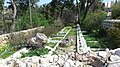
The [[National Botanic Garden of Israel]], also called the '''Land of Israel Botanic Garden''', was founded on the grounds of the Hebrew University on Mount Scopus by botanist [[Alexander Eig]] in 1931. This garden contains one of the largest collections of Israeli uncultivated plants. This was the first home of the [[Jerusalem Biblical Zoo]].<ref>{{cite news|url=http://www.ynetnews.com/articles/0,7340,L-3349288,00.html |title=More than just Mount Scopus – Israel Travel, Ynetnews |work=Ynet |date=June 20, 1995 |access-date=2013-03-26 |last1=Peled |first1=Ron }}</ref> A cave in the garden has been identified as the Tomb of Nicanor (see [[#Cave of Nicanor|above]]). |
|||
[[Category:Mountains of Jerusalem]] |
|||
[[Category:Neighbourhoods of Jerusalem]] |
|||
===Jerusalem British War Cemetery=== |
|||
[[cs:Skopus]] |
|||
The [[Jerusalem British war cemetery]] is a military cemetery for fallen soldiers of the [[British Empire]], later known as the [[Commonwealth of Nations]], in [[World War I]] in [[Mandatory Palestine]]. The cemetery is located on the neck of land on the north end of the [[Mount of Olives]] and west of Mount Scopus.<ref name=cwgc1>{{cite web|url=http://www.cwgc.org/find-a-cemetery/cemetery/71401/JERUSALEM%20WAR%20CEMETERY|title=Cemetery Details|first=Reading Room|last=Manchester}}</ref> |
|||
[[de:Skopus (Berg)]] |
|||
[[es:Monte Scopus]] |
|||
2515 were buried in the cemetery fallen soldiers, of 2449 war dead, including 2218 British casualties. A total 100 fallen soldiers are unidentified.<ref name=cwgc1 /> |
|||
[[fr:Mont Scopus]] |
|||
[[he:הר הצופים]] |
|||
A memorial was placed in the cemetery to 3300 service personnel killed in operations in [[Palestine (region)|Palestine]] and [[Egypt]] who have no known grave.<ref name=cwgc2>{{cite web|url=http://www.cwgc.org/find-a-cemetery/cemetery/142016/JERUSALEM%20MEMORIAL|title=Cemetery Details|first=Reading Room|last=Manchester}}</ref> In all, commemorated in this cemetery are 5815 service personnel of World War I. No casualties buried in the cemetery died after the war. |
|||
[[sk:Skopus]] |
|||
[[fi:Scopusvuori]] |
|||
===Kiryat Menachem Begin=== |
|||
[[Kiryat Menachem Begin]], named after former Israeli Prime Minister [[Menachem Begin]] and also known as Kiryat HaMemshala, is a complex of government buildings in [[East Jerusalem]] located between [[Sheikh Jarrah]] in the north, adjacent to Mount Scopus in the east and [[Battle of Ammunition Hill|Ammunition Hill]] in the west. It serves as home to several government offices, along with the [[Kiryat HaMemshala|main government complex]] in [[Givat Ram]]. It also includes the [[National Headquarters of the Israel Police]]. |
|||
===Tabachnik Garden=== |
|||
[[Tabachnik Garden]] is a [[National parks and nature reserves of Israel|National Park]] located on the southern slopes of Mount Scopus, next to the Hebrew University. The park preserves some Jewish burial caves from the [[Second Temple period]] and it also contains two smaller cemeteries, the Bentwich Cemetery and one of the cemeteries of the American Colony. Inside the park there are two lookouts, one facing eastward towards the [[Dead Sea]] and the [[Judean Desert]], the other westward towards the [[Temple Mount]]. |
|||
====Jerusalem American Colony Cemetery==== |
|||
The [[Jerusalem American Colony Cemetery (Mount Scopus)|American Colony Cemetery on Mount Scopus]] is the main cemetery of [[American Colony, Jerusalem|Jerusalem's American Colony]], located next to the Hebrew University in the Tabachnik Garden. Among those buried there are [[Anna Spafford]] and [[Jacob Spafford (Eliahu)|Jacob Spafford]] (1864–1932), born in Ramallah as Jacob Eliahu into a Turkish Jewish family, adoptive son of [[Horatio Spafford|Horatio]] and Anna Spafford and discoverer of the [[Siloam inscription]].<ref>{{cite web|url=http://www.israeldailypicture.com/2012/06/how-strange-does-american-colony-story.html|title=How Strange Does the ''American Colony'' Story Get? Meet the Founders' adopted Jewish son, responsible for one of the most incredible archeological finds in Jerusalem in 130 years}}</ref> |
|||
====Bentwich Cemetery==== |
|||
A small cemetery, dedicated to [[Herbert Bentwich]] and his family, is located beside the American Colony Cemetery in Tabachnik Garden. |
|||
===Ammunition Hill=== |
|||
[[Ammunition Hill]] was a fortified Jordanian military post in the north-west side of Mount Scopus in [[Jerusalem]] that was in the northern part of [[Jordanian annexation of the West Bank|Jordanian]] [[East Jerusalem]]. It was the site of one of the fiercest battles of the [[Six-Day War]]. |
|||
==Gallery== |
|||
<gallery> |
|||
File:הגן הבוטני הלאומי ע"ש מונטגיו למפורט - הר הצופים.jpg|The [[National Botanic Garden of Israel]] |
|||
File:Mount Skopus BW 4.jpg|[[Hecht Synagogue]] |
|||
File:Jerusalem war cemetery 2.JPG|[[Jerusalem British War Cemetery]] |
|||
File:Har Hatsofim IMG 7790.jpg|[[Cave of Nicanor]] |
|||
File:HaMate HaArtzy 2 Jerusalem.jpg|[[National Headquarters of the Israel Police]] |
|||
File:Hadassa 1.JPG|[[Hadassah Hospital]]{{snd}}Mount Scopus |
|||
File:Bezalel.jpg|[[Bezalel Academy of Art and Design]] |
|||
File:בית הקברות של המושבה המאמריקאית בירושלים - הר הצופים 1.jpg|Jerusalem American Colony Cemetery |
|||
File:בית הקברות של משפחת בנטוויץ' - הר הצופים.jpg|Bentwich Cemetery |
|||
File:The Old City of Jerusalem 1.jpg|View of the [[Old City of Jerusalem]] as seen from Mount Scopus |
|||
</gallery> |
|||
==Notes== |
|||
{{notelist}} |
|||
==References== |
|||
{{reflist}} |
|||
==External links== |
|||
*{{Commons category-inline}} |
|||
*[https://web.archive.org/web/20120617040741/http://allaboutjerusalem.com/article/hebrew-university-compound-mount-scopus Mount Scopus – The Hebrew University] |
|||
*[http://allaboutjerusalem.com/tour/brigham-young-university-mormons-center Mount Scopus – The Brigham Young University] |
|||
*[http://www.jerusalemshots.com/cat_en17.html Jerusalem Photos Portal] – Mount Scopus |
|||
{{Authority control}} |
|||
{{DEFAULTSORT:Scopus, Mount}} |
|||
[[Category:Mount Scopus| ]] |
|||
[[Category:Geography of Jerusalem]] |
|||
[[Category:Hills of Israel]] |
|||
[[Category:Former exclaves]] |
|||
[[Category:Landforms of Jerusalem District]] |
|||
Latest revision as of 08:19, 12 April 2024
| Mount Scopus | |
|---|---|
| הַר הַצּוֹפִים Har HaTsofim جبل المشارف Ǧabal al-Mašārif | |
 The Hebrew University campus and tower on Mount Scopus from the north | |
| Highest point | |
| Elevation | 826 m (2,710 ft) |
| Coordinates | 31°47′33″N 35°14′39″E / 31.79250°N 35.24417°E |
| Geography | |
| Location | Jerusalem |
| Parent range | Judaean |


| Part of a series on |
| Jerusalem |
|---|
 |
Mount Scopus (Hebrew: הַר הַצּוֹפִים Har HaTsofim, "Mount of the Watchmen/ Sentinels"; Arabic: جبل المشارف Ǧabal al-Mašārif, lit. "Mount Lookout", or جبل المشهد Ǧabal al-Mašhad "Mount of the Scene/Burial Site", or جبل الصوانة "Mount Syenite") is a mountain (elevation: 826 meters (2,710 ft) above sea level) in northeast Jerusalem.
Between the 1948 Arab–Israeli War and the Six-Day War in 1967, the peak of Mount Scopus with the Hebrew University campus and Hadassah Hospital was a UN-protected exclave of Israel within Jordan. Today, Mount Scopus lies within the municipal boundaries of the city of Jerusalem.
Name and identification[edit]
The ridge of mountains east of ancient as well as modern Jerusalem offers the best views of the city, which it dominates. Since the main part of the ridge bears the name Mount of Olives, the name "lookout" was reserved for this peak to the northeast of the ancient city. Its name in many languages (Hebrew, Arabic, Greek and Latin) means "lookout." Scopus is a Latinisation of the Greek word for "watcher", skopos, the same as in "telescope" (tele- meaning far and skopos – watcher). Adding to the multi-layered meaning of the name, it is also said that in times in which the city's Roman or Byzantine authorities prohibited Jews from entering Jerusalem, they used to come and look at their former capital from this vantage point.[citation needed]
The Hebrew name, Har HaTzofim, "Lookout Mountain", is not mentioned in the Hebrew Bible.[1] It first appears in the form of the Greek "ὁ Σκοπός" (skopós) in the works of Josephus (The Jewish War 2.528;[2] 5.67,[3] 106,[4] first century CE) in connection to Alexander the Great and the 70 CE Roman siege.[1] The Mishnah (third century CE) mentions "Tzofim" in relation to Jerusalem, but it is not at all certain that it means a particular location or rather any point from which the Temple can be seen.[5]
The ancient name Har Hatzofim or Mount Scopus has been affixed to this particular mountain and its peak in the 20th century without the certainty that it corresponds precisely to what Josephus had referred to as Mount Scopus (see Modern era section).
History[edit]
Antiquity[edit]
Overlooking Jerusalem, Mount Scopus has been strategically important as a base from which to attack the city since antiquity. The 12th Roman Legion camped there in 66.[6] In 70, at the conclusion of the same war that led to the destruction of the Jewish Temple, Mount Scopus was used as a base to carry out the final siege of the city by the same 12th Legion, plus the 15th and 5th Legions, while the 10th Legion was positioned on the continuation of the same ridge, known as the Mount of Olives.[7] The Crusaders used it as a base in 1099.[citation needed]
Modern era[edit]


The exact location of the mountain known in the ancient sources as Mount Scopus is not known. It is described as being in the north-eastern part of the ridge that prominently includes the Mount of Olives, which dominates Jerusalem from the east. As the Zionist organisations decided to build a new Jewish institution of higher learning in Jerusalem, which eventually became the Hebrew University, they decided that it was unwise to try and ask for donations for a project designed to be built on the Mount of Olives, a location with many Christian connotations.
The site chosen for the university did correspond approximately to the description of the ancient Mount Scopus and so it was decided to name that particular peak "Mount Scopus". The name became widely used and few Jerusalemites would nowadays know about this rebranding story of an old name. However, the ancient Mount Scopus cannot be far from the modern one.
In 1948, as the British began letting go of their security responsibilities, the Jewish enclave on Mount Scopus became increasingly cut off from the main sections of Jewish Jerusalem. Access to the hospital and university campus was through a narrow road, 2.4 kilometres (1.5 mi) long, passing through the Palestinian neighbourhood of Sheikh Jarrah.[8] Arab sniper fire on vehicles moving along the access route became a regular occurrence, and road mines were laid. When food and supplies at the hospital began to dwindle, a large convoy carrying doctors and supplies set out for the besieged hospital, leading to an attack that became known as the Hadassah medical convoy massacre.[8] Seventy-eight Jewish doctors, nurses, students, patients, faculty members, and Haganah, and one British soldier were killed in the attack.

After the ceasefire agreement of November 30, 1948, which established the division of East and West Jerusalem, Israel controlled the western part of the city while Jordan controlled the east. Several demilitarized "no man's land" zones were established along the border, one of them Mount Scopus.[9] Fortnightly convoys carrying supplies to the university and hospital located in the Israeli part of the demilitarized zone on Mount Scopus were periodically held up by Jordanian troops.[10]
Article VIII of the 1949 Armistice Agreements signed by Israel and Jordan in April 1949[11] called for:
[T]he normal functioning of the cultural and humanitarian institutions on Mount Scopus and free access thereto; free access to the Holy Places and cultural institutions and use of the cemetery on the Mount of Olives; resumption of operation of the Latrun pumping station; provision of electricity for the Old City; and resumption of operation of the railroad to Jerusalem.[11]
In January 1958, Francis Urrutia, a representative of the UN Secretary-General, tried to persuade Jordan to abide by Article VIII, but without success.[10] In May 1958, Jordanian soldiers fired on Israeli patrols, killing a UN officer and four Israeli policemen.
Mount Scopus was not a traditional exclave. There were two versions of the demilitarization agreement: one was initialed by Franklyn M. Begley, a UN official; the local Jordanian commander; and the Israeli local commander; while the other was not initialed by the Israeli local commander. Having two versions of the map was the cause of many incidents within the Mount Scopus area.[12]
[W]ithin the Mount Scopus enclave Israel lacked many aspects of the traditional concept of sovereignty: it could not control cross-border movements (interdependence sovereignty); it lacked de jure and de facto control of the area (Vattelian sovereignty) as the area was subject to UN control; and it arguably also lacked recognition on the part of all those who lived within the bounds of the enclave, as it would be presumptuous to assume that the inhabitants of the Arab village of Issawiya, which was located within the enclave, would have recognized Israel (domestic sovereignty).
Seen from the Israeli perspective, which is easier to adopt due to archival accessibility, one may say that every move that the state of Israel made within the bounds of the enclave was designed to assert its sovereignty while at the same time consolidating and expanding its territory. Put differently, sovereignty – and not its absence – appears to be the fundamental issue that governed all developments throughout the enclave’s existence.[13]
Ralph Bunche, assistant to UN Secretary-General Dag Hammarskjöld visited Jerusalem and Amman to find a solution, followed by Hammarskjöld himself, again unsuccessfully.[10] The Mount Scopus Agreement signed on July 7, 1948, regulated the demilitarised zone around Mount Scopus and authorized the United Nations Truce Supervision Organization to settle disputes between the Israelis and Jordanians.
Two Jewish-owned plots in Issawiya known as Salomons Garden were purchased by Mrs. V.F. Salomons in 1934 and sold to the Gan Shlomit Company, Ltd. in 1937.[12] It was surrounded by a fence, but clashes erupted when Arabs living on the other side of the fence sought to cultivate land, pick olives, and carry out repairs on homes close to the fence. The Arabs were requested not to work closer than fifty metres from the fence unless prior permission was granted by the Israeli police.[12]
Landmarks[edit]
Hebrew University of Jerusalem[edit]
Construction of the Mount Scopus campus of the Hebrew University began in 1918 on land purchased from the Gray Hill estate. The dedication ceremony was held in 1925 in the presence of many dignitaries.[14] A design for the university campus by Sir Patrick Geddes positioned the university buildings on the slopes of the mount, below a domed, hexagonal Great Hall recalling the Star of David, as a counterpoint to the octagonal Dome of the Rock in the Old City.[15] This plan was never implemented, but Geddes designed the university Library, today the Hebrew University Faculty of Law on Mount Scopus.[15]
By 1947, the university was a solid research and teaching institution with humanities, science, medicine, education and agriculture departments (in Rehovot), a national library, a university press and an adult education center. The university had a student population of over 1,000 and 200 faculty members.[14]
Bezalel Academy of Arts and Design[edit]
Bezalel Academy of Arts and Design is Israel's national school of art, founded in 1906 by Boris Schatz. It is named for the Biblical figure Bezalel (Hebrew: בְּצַלְאֵל, romanized: Bəṣalēl), who was appointed by Moses to oversee the design and construction of the Tabernacle in Exodus 35:30-35.[a]
The university's main campus was located on Mount Scopus from 1990 to 2023.[16][17]
Cave of Nicanor[edit]
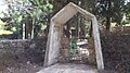
The Cave of Nicanor is an ancient burial cave located on Mount Scopus in Jerusalem, Israel. Excavations in the cave discovered an ossuary referring to "Nicanor the door maker."[18] He has been identified as Nicanor of Alexandria, who donated one of the gates of Herod's Temple.[19] The cave is located in the National Botanic Garden of Israel.
There was a plan to use the Cave of Nicanor as a national Pantheon of Zionism, but due to circumstances (the area of Mount Scopus after receipt of Israel's independence was an enclave, surrounded by the West Bank territorial possessions of Jordan), this project was not implemented. Only two of Zionist leaders – Leon Pinsker and Menachem Ussishkin – were interred inside the ancient tomb. After 1948, the national cemetery was created on Mount Herzl, closer to the centre of West Jerusalem.
Hadassah Hospital (Mount Scopus)[edit]
In 1939, the Hadassah Women's Organization opened a teaching hospital on Mount Scopus[20] in a building designed by architect Erich Mendelsohn. In 1948, when the Jordanians occupied East Jerusalem and blockaded the road to Mount Scopus, the hospital could no longer function.[20] In 1960, after running clinics in various locations, the organization opened a medical center on the other side of the city, in Jerusalem's Ein Karem neighborhood.[20] On April 13, 1948, a civilian convoy bringing medical supplies and personnel to Hadassah Hospital on Mount Scopus was attacked by Arab forces. 78 Jews, mainly doctors and nurses, were killed in the ambush.[21]
Hecht Synagogue, Hebrew University[edit]
The Hecht Synagogue, a large noticeable building on the south-west corner of the campus, was erected by the family of Mayer Jacob "Chic" Hecht (1928–2006), a Republican United States Senator from Nevada and U.S. Ambassador to the Bahamas. It is noted for the unique arrangement of the Torah ark and the panoramic view of the Old City from a huge window.[22]
National Botanical Garden of Israel[edit]
The National Botanic Garden of Israel, also called the Land of Israel Botanic Garden, was founded on the grounds of the Hebrew University on Mount Scopus by botanist Alexander Eig in 1931. This garden contains one of the largest collections of Israeli uncultivated plants. This was the first home of the Jerusalem Biblical Zoo.[23] A cave in the garden has been identified as the Tomb of Nicanor (see above).
Jerusalem British War Cemetery[edit]
The Jerusalem British war cemetery is a military cemetery for fallen soldiers of the British Empire, later known as the Commonwealth of Nations, in World War I in Mandatory Palestine. The cemetery is located on the neck of land on the north end of the Mount of Olives and west of Mount Scopus.[24]
2515 were buried in the cemetery fallen soldiers, of 2449 war dead, including 2218 British casualties. A total 100 fallen soldiers are unidentified.[24]
A memorial was placed in the cemetery to 3300 service personnel killed in operations in Palestine and Egypt who have no known grave.[25] In all, commemorated in this cemetery are 5815 service personnel of World War I. No casualties buried in the cemetery died after the war.
Kiryat Menachem Begin[edit]
Kiryat Menachem Begin, named after former Israeli Prime Minister Menachem Begin and also known as Kiryat HaMemshala, is a complex of government buildings in East Jerusalem located between Sheikh Jarrah in the north, adjacent to Mount Scopus in the east and Ammunition Hill in the west. It serves as home to several government offices, along with the main government complex in Givat Ram. It also includes the National Headquarters of the Israel Police.
Tabachnik Garden[edit]
Tabachnik Garden is a National Park located on the southern slopes of Mount Scopus, next to the Hebrew University. The park preserves some Jewish burial caves from the Second Temple period and it also contains two smaller cemeteries, the Bentwich Cemetery and one of the cemeteries of the American Colony. Inside the park there are two lookouts, one facing eastward towards the Dead Sea and the Judean Desert, the other westward towards the Temple Mount.
Jerusalem American Colony Cemetery[edit]
The American Colony Cemetery on Mount Scopus is the main cemetery of Jerusalem's American Colony, located next to the Hebrew University in the Tabachnik Garden. Among those buried there are Anna Spafford and Jacob Spafford (1864–1932), born in Ramallah as Jacob Eliahu into a Turkish Jewish family, adoptive son of Horatio and Anna Spafford and discoverer of the Siloam inscription.[26]
Bentwich Cemetery[edit]
A small cemetery, dedicated to Herbert Bentwich and his family, is located beside the American Colony Cemetery in Tabachnik Garden.
Ammunition Hill[edit]
Ammunition Hill was a fortified Jordanian military post in the north-west side of Mount Scopus in Jerusalem that was in the northern part of Jordanian East Jerusalem. It was the site of one of the fiercest battles of the Six-Day War.
Gallery[edit]
-

-

-

-

-

-
 Hadassah Hospital – Mount Scopus
 -

-
 Jerusalem American Colony Cemetery
 -
 Bentwich Cemetery
 -
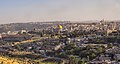 View of the Old City of Jerusalem as seen from Mount Scopus


Notes[edit]
- ^ "Exodus 35:30-35". www.sefaria.org. Retrieved February 18, 2024.
And Moses said to the Israelites: See, יהוה has singled out by name Bezalel, son of Uri son of Hur, of the tribe of Judah, endowing him with a divine spirit of skill, ability, and knowledge in every kind of craft, and inspiring him to make designs for work in gold, silver, and copper, to cut stones for setting and to carve wood—to work in every kind of designer's craft—and to give directions. He and Oholiab son of Ahisamach of the tribe of Dan have been endowed with the skill to do any work—of the carver, the designer, the embroiderer in blue, purple, crimson yarns, and in fine linen, and of the weaver—as workers in all crafts and as makers of designs.
References[edit]
- ^ a b Mount Scopus. Retrieved 15 Feb 2021.
- ^ Jewish War 2:528
- ^ Jewish War 5:67
- ^ Jewish War 5:106
- ^ Zoldan, Rabbi Yehuda. "הצופים לירושלים [HaTzofim LeYerushalayim, lit. 'Watchmen to Jerusalem']" (in Hebrew). The Torah and the Land Institute; Bulletin No. 36, Tammuz 5769 [June–July 2009]. Retrieved February 15, 2021.
- ^ Rome and Jerusalem; The Clash of Ancient Civilizations. Martin Goodman p. 13
- ^ The Jewish Wars Josephus v 81 and 82
- ^ a b Larry Collins and Dominique Lapierre, O Jerusalem!, 1972, pp. 284–285, Simon & Schuster, New York ISBN 0-671-66241-4.
- ^ "Middle East Historical Documents – Text of Jordanian Israeli Armistice Agreement, 1949".
- ^ a b c Encyclopedia Judaica, "Jerusalem," vol. 9, pp. 1497, Keter, Jerusalem, 1978
- ^ a b UN Doc S/1302/Rev.1 of April 3, 1949 Archived October 29, 2014, at the Wayback Machine Hashemite Jordanian Kingdom Israel Armistice Agreement
- ^ a b c Unispal.un.org Report of the Firing Incident of May 26, 1958 on Mount Scopus UN Doc S/4030 17 June 1958, paragraph 80
- ^ Weiss, Yfaat (March 18, 2016). "Sovereignty and the Mount Scopus Enclave in Jerusalem". LawLog (in German). Retrieved February 18, 2024.
- ^ a b "The Hebrew University of Jerusalem – History". Huji.ac.il. January 23, 2013. Retrieved March 26, 2013.
- ^ a b "Hadassah Magazine". Hadassah.org. Archived from the original on May 6, 2005. Retrieved March 26, 2013.
- ^ Zandberg, Esther (December 9, 2010). "No Way Home". Haaretz. Retrieved January 1, 2024.
- ^ "Bezalel opens the semester at the new campus: The President of the Academy addresses the celebration alongside recent events in the country". Bezalel Academy of Arts and Design, Jerusalem. March 21, 2023. Retrieved January 1, 2024.
- ^ Clermont-Ganneau, "Archeological and epigraphic notes on Palestine," Palestine Exploration Fund Quarterly Statement, 1903, pp. 125–131; Gladys Dikson, "The tomb of Nicanor of Alexandria," Palestine Exploration Fund Quarterly Statement, 1903, pp. 326–332
- ^ Segev, Tom (May 15, 2008). "Man Bites History". Haaretz. Retrieved February 18, 2024.
- ^ a b c Yarrow, Andrew L. (January 23, 1987). "Hadassah Celebrates 75 Years of Helping". The New York Times.
- ^ "Hadassah Convoy Massacre". Zionism-israel.com. Retrieved March 26, 2013.
- ^ Harrison, Don. "Synagogue Profile Hecht Synagogue, Hebrew University".
- ^ Peled, Ron (June 20, 1995). "More than just Mount Scopus – Israel Travel, Ynetnews". Ynet. Retrieved March 26, 2013.
- ^ a b Manchester, Reading Room. "Cemetery Details".
- ^ Manchester, Reading Room. "Cemetery Details".
- ^ "How Strange Does the American Colony Story Get? Meet the Founders' adopted Jewish son, responsible for one of the most incredible archeological finds in Jerusalem in 130 years".
External links[edit]
 Media related to Mount Scopus at Wikimedia Commons
- Mount Scopus – The Hebrew University
- Mount Scopus – The Brigham Young University
- Jerusalem Photos Portal – Mount Scopus
| Authority control databases: National |
|---|