Vinalopó Mitjà: Difference between revisions
Content deleted Content added
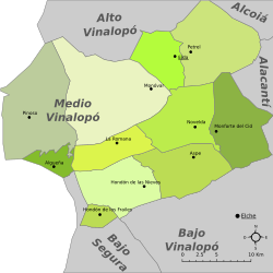
Better map that also includes the most used names both in Wikipedia and in real life. Keeping the 2nd map as well. |
Putting the name in both Valencian and Spanish. |
||
| Line 107: | Line 107: | ||
| align=right | 8,165 |
| align=right | 8,165 |
||
|- |
|- |
||
| [[Monòver]] |
| [[Monòver|Monòver / Monóvar]] |
||
| align=right | 152.40 |
| align=right | 152.40 |
||
| align=right | 11,763 |
| align=right | 11,763 |
||
Revision as of 19:32, 1 December 2022
Vinalopó Mitjà
| |
|---|---|
 | |
| Country | |
| Autonomous community | |
| Province | Alicante / Alacant |
| Capital | Elda |
| Municipalities | |
| Area | |
| • Total | 798.60 km2 (308.34 sq mi) |
| Population (2019)[1] | |
| • Total | 169,069 |
| • Density | 210/km2 (550/sq mi) |
| Time zone | UTC+1 (CET) |
| • Summer (DST) | UTC+2 (CEST) |
| Largest municipality | Elda |
Vinalopó Mitjà[a] (Spanish: Vinalopó Medio,[b] lit. "Middle Vinalopó") is a comarca in the province of Alicante, Valencian Community, Spain.
Municipalities

The comarca comprises eleven municipalities, listed below with their areas and populations:
| Name | Area in km2 |
Population (2001)[2] |
Population (2011)[3] |
Population (2019)[4] |
|---|---|---|---|---|
| Algueña / L'Alguenya | 18.50 | 1,453 | 1,506 | 1,336 |
| Aspe / Asp | 70.90 | 16,631 | 20,186 | 20,714 |
| Elda | 45.80 | 51,593 | 54,357 | 52,618 |
| El Fondó de les Neus / Hondón de las Nieves | 68.80 | 1,660 | 2,731 | 2,544 |
| El Fondó dels Frares / Hondón de los Frailes | 12.60 | 622 | 1,109 | 1,198 |
| Monforte del Cid | 79.50 | 5,576 | 7,749 | 8,165 |
| Monòver / Monóvar | 152.40 | 11,763 | 12,683 | 12,167 |
| Novelda | 75.70 | 24,800 | 26,573 | 25,651 |
| Petrer / Petrel | 104.20 | 30,138 | 34,690 | 34,276 |
| Pinoso / El Pinós | 126.90 | 6,370 | 7,742 | 7,966 |
| La Romana | 43.30 | 2,044 | 2,463 | 2,434 |
| Totals | 798.60 | 152,650 | 171,789 | 169,069 |
Notes
- ^ Valencian pronunciation: [vinaloˈpo miˈdʒa]
- ^ Spanish pronunciation: [vinaloˈpo ˈmeðjo]
References
- ^ Official estimate as at 1 January 2019: Instituto Nacional de Estadística, Madrid, 2019.
- ^ Census of 1 November 2001: Instituto Nacional de Estadística, Madrid, 2019.
- ^ Census of 1 November 2011: Instituto Nacional de Estadística, Madrid, 2019.
- ^ Official estimate as at 1 January 2019: Instituto Nacional de Estadística, Madrid, 2019.
