
Andros, Bahamas
Template:Island of the Bahamas
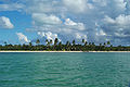
Andros Island is the largest island of the Bahamas, and North Andros is the sixth largest island in the West Indies, at roughly 6,000 km2 (2,300 sq mi) in area and 167 km (104 mi) long and 64 km (40 mi) wide at its widest point. It is actually composed of three major islands: North Andros, Mangrove Cay, and South Andros. The island has the world's third largest barrier reef, which is over 225 km (140 mi) long. It is affectionately known by Bahamians as the "Big Yard". Andros is the least densely populated of all the Bahamas, with a population of a little over six thousand. Most of these people live on the east coast of the island in the three major towns on the island; Nicholls Town and Andros Town on North Andros, and Congo Town, on South Andros.
Much freshwater comes from this island, with about nineteen million litres of freshwater being shipped to Nassau a day through the pumping station located in Morgan's Bluff.[1][2] Andros has thousands of kilometres of freshwater rivers that come from rainwater collected in the many caves in the island's interior.
A type of fabric called Androsia is manufactured in Andros. Androsia is the local type of batik fabric, produced in a variety of bright vibrant colors and designs. It is distributed widely throughout the Bahamas.
The Chickcharnie, an extinct cryptid believed by some to be based on the flightless, 1 metre tall barn-owl, Tyto pollens, is said to have formerly occurred on Andros.[citation needed]
Andros is hit by a hurricane on average every two and a half years.
The AUTEC- Atlantic Underwater Testing and Evaluation Center Deep Water Weapons Range runs parallel to the east coast of the islands, and operates a base on North Andros.
International Field Studies, Inc. runs Forfar Field Station, located on the east coast near North Blanket Sound.[3] Students can stay there to learn about the culture, biology, and geology of the Bahamas.
Etymology
The Spanish named the island “Espiritu Santo,” the Island of the Holy Spirit. A 1782 map calls it San Andreas.[citation needed] The modern name is believed to be in honour of Sir Edmund Andros, Commander of Her Majesty’s Forces in Barbados in 1672 and governor successively of New York, Massachusetts, and New England.[citation needed] However, the island could have been named after the inhabitants of St Andro Island (St Andrew or San Andrés) on the Mosquito Coast, since 1,400 of them settled in Andros in 1787.[citation needed] A less likely theory suggests that the island was name after the Greek isle of Andros by Greek sponge fishermen.[4]
History
The first inhabitants of Andros Island were probably the indigenous Lucayan people. The Lucayans throughout the Bahamas were wiped out mainly by exposure to disease following the arrival of the Spanish in the 1550s.
It is believed that Andros Island was named for Edmund Andros, who served as commander of British Forces in Barbados in 1672, and later the second governor of the Dominion of New England, until deposed during the upheaval of the Glorious Revolution.
During the 18th century pirates occupied the island. Morgan's Bluff and Morgan's Cave on North Andros are named after the famous privateer-pirate, Henry Morgan. Loyalists and their slaves also settled in Andros in the late 18th century.
Andros Island's port of Fresh Creek was once a popular hangout for the "Rat Pack," including Sammy Davis, Jr..
In the 1960s and 1970s the Owens Lumber company, a US-owned company, deforested much of the indigenous pineyards that grew on North Andros. As a result of poor planning for re-growth, what is found on the island today are over-crowded forests of mainly young trees.
Owing to its proximity to the Tongue of the Ocean and network of fresh and saltwater blue holes, Andros Island became a popular scuba diving destination in the early days of the sport, frequented by such well known divers as Jacques Cousteau. The first dive resort on Andros was built by Archie Forfar, a Canada native who later died trying to break the Guinness world record for deep diving. His resort, in Blanket Sound, is now home to Forfar Field Station, an environmental education facility owned and operated by International Field Studies.[citation needed]
Districts and Townships
Andros is subdivided into four Districts and ten Townships for administrative purposes.
| Districts of Andros Island[5] | Chief Councillor[6] | Establishment | Seat of Local Government[7] | Townships[8] | Map |
|---|---|---|---|---|---|
| North Andros District | Brian O’Neal Cleare | 1999 | Nicholls Town | Mastic Point, Lowe Sound, Nicholl's Town | 
|
| Central Andros District | Clyde Duncombe | 1999 | Fresh Creek | Staniard Creek, Fresh Creek, Cargill Creek | 
|
| Mangrove Cay District | Brian Moxey | 1999 | Mangrove Cay (Settlement) | none | 
|
| South Andros District | Zebedee Rolle | 1999 | Kemps Bay | The Bluff, Long Bay Cays, Kemps Bay, Deep Creek | 
|
Transportation
Andros Town International Airport serves the island.
Economy
Western Air has its head office on the grounds of San Andros Airport.[9]
Tourism
Unlike most of the Bahamian islands, Andros's interior has been largely free of commercial development for the tourism industry, preserving much of its natural beauty. Current Bahamian tourism efforts refer to it as the least-explored island in the chain.[10] There are currently efforts being made by the Bahamas National Trust and the Nature Conservancy to establish a national park on the island.
The island is filled with natural beauty. The east coast of Andros Island lies along the Tongue of the Ocean, a deep oceanic trench. In part because of this location, the east coast of the island is bordered by the best developed fringing reef system in all of The Bahamas (and one of the best in the entire Wider Caribbean region), with a vertical drop on many parts of the fore reef plunging to depths of over 1.8 km (5,900 ft). So extensive is this reef system that it is sometimes referred to as a "barrier reef", but it is not a true barrier reef in the strict definition because it contains only a shallow lagoon that is relatively close to shore. As a compormise, some have taken to calling this a "fringing barrier reef" [11]
There are more than 104 km2 (40 sq mi) of subtropical forests and the swamps are inhabited by more than 50 species of orchids. Andros is actually made up of three different major islands (North Andros, Mangrove Cay and South Andros) and hundreds of cays adjoined by these mangrove estuaries and tidal swamp lands. Two hundred different types of birds are native to the island.
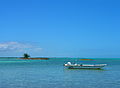
Andros Island draws thousands of visitors every year. There are few hotels and resorts on the island. However Andros, famous for its bonefishing, and is home to many lodges which cater to the sport. Anglers come from all over the world to fish there. It is said to be "the bonefish capital of the world". Additionally, many divers come to explore the blue holes and spectacular coral reefs.
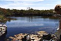
Blue holes
The island's blue holes are water filled cave systems. They attract cave divers from all over the world to dive sites such as 'Stargate', 'The Guardian' and 'Little Frenchman'. There are blue holes in the ocean and inland. Two of the inland blue holes on Andros include Charlie's Blue Hole, reputedly first explored by Jacques-Yves Cousteau, and the larger Church's Blue Hole and Guardian Blue Hole.[12]
Religion
There are a number of church denominations represented within Andros. In North Andros, the Anglican Episcopal Church has a presence through St Margaret's Parish.[13] This parish consists of two churches, St Margaret's located in the settlement of Nicholls Town and St Mary Magdalene located in the settlement of Mastic Point.
The Roman Catholic Archdiocese of Nassau[14] provides clergy for parishes throughout Andros. On South Andros Sacred Heart parish is in Little Creek and St. Robert Bellarmine parish is in High Rock. Mangrove Cay is served by St. Benedict's parish and Central Andros is served by St. John Chrysostom parish in Fresh Creek and Christ the King parish in Cargill Creek. Catholic services are also provided on Saturday evening at the AUTEC Navy Base chapel.
Gallery
-
 South Andros Island, at Tiamo.
 -
 Guardian Blue Hole
 -
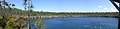
 View from Saddleback Cay
 -
 Sunset from Blanket Sound
 -
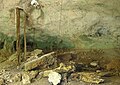 Captain Morgan's Cave
 -
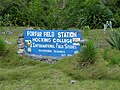 Forfar Field Station
 -
 Church's Blue Hole
 -
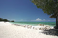 The North Beach of Small Hope Bay Lodge


See also
References
- ^ "Adros Scuba Centre & Dive Resort - Andros Island, Bahamas". Retrieved 20 December 2010.
- ^ Michael Carr. "Water, Precious Water". Retrieved 20 December 2010.
- ^ "Forfar Field Station". Retrieved 20 December 2010.
- ^ McMorran, Jennifer. The Islands of the Bahamas. p. 271.
- ^ "Family Island District Councillors & Town Committee Members". Retrieved 20 December 2010.
- ^ "Family Island District Councillors & Town Committee Members". Retrieved 20 December 2010.
- ^ "Posting of Administrators As at 5th January, 2010". Retrieved 20 December 2010.
- ^ "Family Island District Councillors & Town Committee Members". Retrieved 20 December 2010.
- ^ "About Us." Western Air. Retrieved on 16 May 2010.
- ^ "Andros". Retrieved 20 December 2010.
- ^ The Andros Barrier Reef, The Andros Conservancy and Trust Bahamas (ANCAT)
- ^ Rob Palmer, Deep into Blue Holes. Unwin Hyman Limited, 1989. ISBN 0-04-440380-1.
- ^ "?".[dead link]
- ^ "Archdiocese of Nassau homepage". Retrieved 20 December 2010.