
Cap Tourmente National Wildlife Area: Difference between revisions
has landforms within it, yes, but is not itself literally a landform |
Tom.Reding (talk | contribs) m +{{Authority control}} (2 IDs from Wikidata), WP:GenFixes on |
||
| Line 1: | Line 1: | ||
{{ |
{{Short description|National Wildlife Area in Quebec, Canada}} |
||
{{Expand French|Réserve nationale de faune du cap Tourmente|topic=geo|date=April 2010}} |
{{Expand French|Réserve nationale de faune du cap Tourmente|topic=geo|date=April 2010}} |
||
{{Infobox protected area |
{{Infobox protected area |
||
| Line 53: | Line 53: | ||
==External links== |
==External links== |
||
{{ |
{{Commons category-inline|Réserve nationale de faune du Cap-Tourmente}} |
||
*[http://www.ec.gc.ca/ap-pa/default.asp?lang=En&n=0533BC0A-1# Cap Tourmente National Wildlife Area] at Environment Canada |
*[http://www.ec.gc.ca/ap-pa/default.asp?lang=En&n=0533BC0A-1# Cap Tourmente National Wildlife Area] at Environment Canada |
||
{{Ramsar sites in Canada}} |
{{Ramsar sites in Canada}} |
||
{{Authority control}} |
|||
[[Category:Ramsar sites in Canada]] |
[[Category:Ramsar sites in Canada]] |
||
Revision as of 16:22, 22 April 2021
You can help expand this article with text translated from the corresponding article in French. (April 2010) Click [show] for important translation instructions.
|
| Cap Tourmente National Wildlife Area | |
|---|---|
| Réserve nationale de faune du cap Tourmente | |
IUCN category IV (habitat/species management area) | |
 Scenery at the Cap Tourmente National Wildlife Area. | |
| Location | Saint-Joachim, La Côte-de-Beaupré Regional County Municipality, Quebec, Canada |
| Coordinates | 47°5′N 70°47′W / 47.083°N 70.783°W |
| Area | 23.99 km2 (9.26 sq mi) |
| Established | April 28, 1978 |
| Governing body | Canadian Wildlife Service |
| Official name | Cap Tourmente |
| Designated | 15 January 1981 |
| Reference no. | 214[1] |
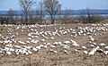
The Cap Tourmente National Wildlife Area is a National Wildlife Area located on the north shore of the Saint Lawrence River in the National Provincial Capital Region of Quebec, established on 28 April 1978. It is one of the critical habitats for the greater snow goose during migration. Flocks of tens of thousands of these birds stop over to feed on the bullrushes in the spring and fall. The tidal marsh was recognized as a wetland of international significance per the Ramsar Convention in 1981, the first North American site to receive that distinction.[2]
Within the wildlife refuge is a historic farm site, La Petite-Ferme du cap Tourmente, which was begun by Samuel de Champlain in 1626, as a food source for the fledgling Habitation at Quebec City. Later, the farm was purchased and run for nearly 300 years by and for the Seminary of Quebec. A farm house built around 1667 still stands, and is at the core of La Petite-Ferme du cap Tourmente National Historic Site, designated in 2018.[3]
-
-
 American tree sparrow (Spizelloides arborea)


References
- ^ "Cap Tourmente". Ramsar Sites Information Service. Retrieved 25 April 2018.
- ^ "Greater Snow Goose". Hinterland Who's Who. Environment Canada and the Canadian Wildlife Federation. Archived from the original on 2010-12-05. Retrieved 2010-12-15.
In 1981, the Cap Tourmente NWA was declared North America's first Ramsar site, a site recognized as a wetland of international importance.
- ^ Government of Canada Announces 12 New National Historic Designations, Parks Canada news release, March 27, 2018
External links
![]() Media related to Réserve nationale de faune du Cap-Tourmente at Wikimedia Commons
Media related to Réserve nationale de faune du Cap-Tourmente at Wikimedia Commons
- Cap Tourmente National Wildlife Area at Environment Canada
This Quebec location article is a stub. You can help Wikipedia by expanding it. |