Cunday: Difference between revisions
Content deleted Content added
m Robot - Speedily moving category Municipalities of Tolima to Category:Municipalities of Tolima Department per CFDS. |
mNo edit summary |
||
| (6 intermediate revisions by 5 users not shown) | |||
| Line 5: | Line 5: | ||
|motto = |
|motto = |
||
|settlement_type = [[Municipalities of Colombia|Municipality]] and town |
|settlement_type = [[Municipalities of Colombia|Municipality]] and town |
||
|image_skyline = |
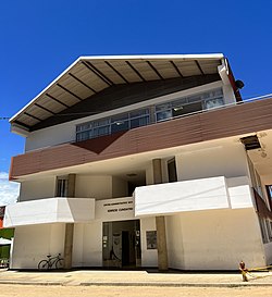
|image_skyline = Centro Administrativo Municipal de Cunday.jpg |
||
|imagesize = |
|imagesize = 250px |
||
|image_caption = |
|image_caption = Cunday Administrative Center Building |
||
|image_flag = Flag of Cunday.svg |
|image_flag = Flag of Cunday.svg |
||
|image_seal = Escudo de Cunday.svg |
|image_seal = Escudo de Cunday.svg |
||
| Line 22: | Line 22: | ||
|subdivision_type2 = |
|subdivision_type2 = |
||
|subdivision_name2 = |
|subdivision_name2 = |
||
|leader_title = |
|leader_title = [[Mayor]] |
||
|leader_name = |
|leader_name = Evelio Girón Molina |
||
|established_title = |
|established_title = |
||
|established_date = |
|established_date = |
||
|area_magnitude = |
|area_magnitude = |
||
|area_total_km2 = |
|area_total_km2 = 526 |
||
|area_total_sq_mi = |
|area_total_sq_mi = |
||
|area_land_km2 = |
|area_land_km2 = |
||
| Line 38: | Line 38: | ||
|area_metro_km2 = |
|area_metro_km2 = |
||
|area_metro_sq_mi = |
|area_metro_sq_mi = |
||
|population_as_of = |
|population_as_of = 2017 |
||
|population_note = |
|population_note = |
||
|population_total = |
|population_total = 9544 |
||
|population_density_km2 = |
|population_density_km2 = auto |
||
|population_density_sq_mi = |
|population_density_sq_mi = |
||
|population_metro = |
|population_metro = |
||
| Line 47: | Line 47: | ||
|population_density_metro_sq_mi = |
|population_density_metro_sq_mi = |
||
|population_urban = |
|population_urban = |
||
|coordinates = |
|||
|latd=|latm=|lats= |latNS=N |
|||
|longd=|longm=|longs= |longEW=W |
|||
|timezone = Colombia Standard Time |
|timezone = Colombia Standard Time |
||
|utc_offset = -5 |
|utc_offset = -5 |
||
|timezone_DST = |
|timezone_DST = |
||
|utc_offset_DST = |
|utc_offset_DST = |
||
|elevation_m = |
|elevation_m = 475 |
||
|elevation_ft = |
|elevation_ft = |
||
|website = |
|website = |
||
| Line 65: | Line 64: | ||
{{coord|4|05|N|74|40|W|display=title|region:CO_type:adm2nd_source:GNS-enwiki}} |
{{coord|4|05|N|74|40|W|display=title|region:CO_type:adm2nd_source:GNS-enwiki}} |
||
[[Category:Populated places in the Tolima Department]] |
|||
[[Category:Municipalities of Tolima Department]] |
[[Category:Municipalities of Tolima Department]] |
||
Latest revision as of 20:32, 1 August 2022
Cunday | |
|---|---|
Municipality and town | |
 Cunday Administrative Center Building | |
 Location of the municipality and town of Cunday in the Tolima Department of Colombia. | |
| Country | |
| Department | Tolima Department |
| Government | |
| • Mayor | Evelio Girón Molina |
| Area | |
| • Total | 526 km2 (203 sq mi) |
| Elevation | 475 m (1,558 ft) |
| Population (2017) | |
| • Total | 9,544 |
| • Density | 18/km2 (47/sq mi) |
| Time zone | UTC-5 (Colombia Standard Time) |
Cunday is a town and municipality in the Tolima department of Colombia. The population of the municipality was 11,440 as of the 1993 census.


