
Diever: Difference between revisions
No edit summary |
Citation bot (talk | contribs) Alter: title. | Use this bot. Report bugs. | Suggested by BrownHairedGirl | #UCB_webform 2319/3841 |
||
| (29 intermediate revisions by 23 users not shown) | |||
| Line 1: | Line 1: | ||
| ⚫ | |||
{{Infobox settlement |
{{Infobox settlement |
||
| name = Diever |
| name = Diever |
||
| settlement_type = |
| settlement_type = Village |
||
| other_name = <!-- if different from name --> |
| other_name = <!-- if different from name --> |
||
| native_name = <!-- if different from name --> |
| native_name = <!-- if different from name --> |
||
| Line 7: | Line 8: | ||
| image_skyline = Sint-Pancratiuskerk Diever.jpg |
| image_skyline = Sint-Pancratiuskerk Diever.jpg |
||
| image_alt = |
| image_alt = |
||
| image_caption = [[Sint-Pancratiuskerk (Diever)|Sint-Pancratiuskerk]] |
| image_caption = [[Sint-Pancratiuskerk (Diever)|Sint-Pancratiuskerk]] of Diever |
||
| image_flag = |
| image_flag = |
||
| image_shield = |
| image_shield = |
||
| nickname = |
| nickname = |
||
| motto = |
| motto = |
||
<!-- |
|||
| image_map = LocatieWesterveld.png |
| image_map = LocatieWesterveld.png |
||
--> |
|||
| map_caption = |
| map_caption = |
||
| image_map1 = Map NL - Westerveld - Diever.png |
| image_map1 = Map NL - Westerveld - Diever.png |
||
| map_caption1 = The town centre (dark green) and the statistical district (light green) of Diever in the municipality of Westerveld. |
| map_caption1 = The town centre (dark green) and the statistical district (light green) of Diever in the municipality of Westerveld. |
||
| pushpin_map = |
| pushpin_map = Netherlands Drenthe#Netherlands |
||
| pushpin_label_position = left |
| pushpin_label_position = left |
||
| pushpin_map_caption = Location in the |
| pushpin_map_caption = Location in the province of Drenthe |
||
| subdivision_type = [[List of sovereign states|Country]] |
| subdivision_type = [[List of sovereign states|Country]] |
||
| subdivision_name = [[Netherlands]] |
| subdivision_name = [[Netherlands]] |
||
| Line 28: | Line 31: | ||
| leader_name = |
| leader_name = |
||
| leader_party = |
| leader_party = |
||
| coordinates = {{coord|52|51|20|N|6|19|3|E|region:NL_type:city(2090)|display=inline,title}} |
|||
| latd = 52|latm = 51|lats = 20|latNS = N |
|||
| longd= 6|longm = 19|longs= 3|longEW= E |
|||
| coordinates_region = NL |
|||
| coordinates_type = region:NL_type:city(2090) |
|||
| coordinates_display = inline,title |
|||
| coordinates_footnotes = |
| coordinates_footnotes = |
||
| ⚫ | |||
| elevation_footnotes = <ref name="AHN">{{cite web |url = http://www.ahn.nl/postcodetool |title = Postcodetool for 7981AA |language = nl |work = Actueel Hoogtebestand Nederland |publisher = Het Waterschapshuis |access-date = 12 April 2022 }}</ref> |
|||
| ⚫ | |||
| elevation_min_m = |
| elevation_min_m = |
||
| elevation_max_m = |
| elevation_max_m = |
||
| area_footnotes = |
| area_footnotes = <ref name="stat"/> |
||
| area_total_km2 = |
| area_total_km2 = 36.73 |
||
| |
| area_land_km2 = |
||
| |
| area_water_km2 = |
||
| established_title = |
|||
| population_footnotes = <!-- for references: use <ref> tags --> |
|||
| |
| established_date = |
||
| population_footnotes = <ref name=" |
| population_footnotes = <ref name="stat">{{cite web |url=https://www.cbs.nl/-/media/_excel/2021/48/kwb-2021.xls |title=Kerncijfers wijken en buurten 2021 |website=Central Bureau of Statistics |access-date=12 April 2022}}</ref> |
||
| |
| population_total = 2,715 |
||
| population_as_of = 2021 |
|||
| population_demonym = |
| population_demonym = |
||
| population_note = |
| population_note = |
||
| population_density_km2 = auto |
| population_density_km2 = auto |
||
| population_density_urban_km2 = auto |
|||
| timezone = [[Central European Time|CET]] |
| timezone = [[Central European Time|CET]] |
||
| utc_offset = +1 |
| utc_offset = +1 |
||
| Line 53: | Line 56: | ||
| utc_offset_DST = +2 |
| utc_offset_DST = +2 |
||
| postal_code_type = [[List of postal codes in the Netherlands|Postal code]] |
| postal_code_type = [[List of postal codes in the Netherlands|Postal code]] |
||
| postal_code = |
| postal_code = 7981<ref name="stat"/> |
||
| area_code_type = [[Telephone numbers in the Netherlands|Dialing code]] |
| area_code_type = [[Telephone numbers in the Netherlands|Dialing code]] |
||
| area_code = |
| area_code = 0521 |
||
| website = |
|||
| footnotes = |
|||
}} |
}} |
||
'''Diever''' is a |
'''Diever''' is a village in the [[Netherlands|Dutch]] province of [[Drenthe]]. It is a part of the municipality of [[Westerveld]], and lies about 18 km northwest of [[Hoogeveen]]. |
||
Diever is located near the |
Diever is located near the {{ill|Drentse Hoofdvaart|nl}}, a major north–south route for pleasure boats in the province of Drenthe. Diever is located next to the [[Drents-Friese Wold National Park|Drents-Friese Wold]], one of the national parks in the [[Netherlands]], and a attraction for tourists.<ref>{{cite web|url=https://www.nationaalpark-drents-friese-wold.nl/bezoekers/bezoekerscentra/informatiecentrum/ |title=Informatiecentrum Diever |website=Nationaal park Drents-Friese wold|access-date=12 March 2022|language=nl}}</ref> In the centre of Diever there is the ''[[Brink (plaza)|brink]]'', the village square with old buildings surrounding it. The [[Dutch Reformed Church|Dutch Reformed]] [[Saint Pancratius]]-church is a 15th-century building, and considered one of the most beautiful churches of Drenthe. |
||
Diever was a separate municipality until 1998, when the new municipality of Westerveld was created.<ref>Ad van der Meer and Onno Boonstra, "Repertorium van Nederlandse gemeenten", KNAW, 2006. |
Diever was a separate municipality until 1998, when the new municipality of Westerveld was created.<ref>Ad van der Meer and Onno Boonstra, "Repertorium van Nederlandse gemeenten", KNAW, 2006. {{cite web|url=http://www.knaw.nl/cfdata/publicaties/detail.cfm?boeken__ordernr%3D20061061 |title=KNAW > Publicaties > Detailpagina |accessdate=2009-12-03 |url-status=dead |archiveurl=https://web.archive.org/web/20070220041404/http://www.knaw.nl/cfdata/publicaties/detail.cfm?boeken__ordernr=20061061 |archivedate=20 February 2007}}</ref> |
||
In 2001, the town of Diever had 1941 inhabitants. The built-up area of the town was 0.80 km², and had 810 residences.<ref name="CBS3">Statistics Netherlands (CBS), [http://www.cbs.nl/nl-NL/menu/themas/milieu-natuur-ruimte/ruimte/publicaties/cartografie-geografie/geografische-data/2001-bevolkingskernen-in-nederland.htm ''Bevolkingskernen in Nederland 2001'']. (Statistics are for the continuous built-up area).</ref> |
|||
The statistical area "Diever", which also can include the surrounding countryside, has a population of around 2580.<ref name="CBS2">Statistics Netherlands (CBS), [http://statline.cbs.nl/ ''Statline: Kerncijfers wijken en buurten 2003-2005'']. As of 1 January 2005.</ref> |
|||
==Shakespeare== |
==Shakespeare== |
||
In July and August |
In July and August the local people of Diever perform in dramas written by [[William Shakespeare]].<ref>{{Cite web|url=https://www.shakespearetheaterdiever.nl:443/Archief/Historisch-overzicht|title=Historisch overzicht : Shakespearetheater Diever: Toneel in de open lucht|website=Shakespeare Theater Diever|language=nl|access-date=2020-03-17}}</ref> Diever is also known as "Shakespeare-town".<ref>{{Cite web|url=https://www.shakespearetheaterdiever.nl:443/Archief/Historisch-overzicht|title=Historisch overzicht : Shakespearetheater Diever: Toneel in de open lucht|website=Shakespeare Theater Diever|language=nl|access-date=2020-03-17}}</ref> The plays are being performed in an open-air theatre. The local amateur theater group was formed in 1946 by a local medical doctor, Mr. Derp Broekema.<ref>{{Cite web|url=https://www.shakespearetheaterdiever.nl:443/Archief/Historisch-overzicht|title=Historisch overzicht : Shakespearetheater Diever: Toneel in de open lucht|website=Shakespeare Theater Diever|language=nl|access-date=2020-03-17}}</ref> Thus, in 2006 the 60th anniversary of this annual event was celebrated with the performance of [[Henry IV, Part 1|Henry IV]].<ref>{{cite web|url=https://webshop.shakespearetheaterdiever.nl/a-54844409/vertalingen/henry-iv/#description |title=Henry IV |website=Shakespeare Theater Diever |access-date=12 March 2022 |language=nl}}</ref> |
||
== Gallery == |
|||
<gallery> |
|||
File:Diever Brink 11 - rm 507278.jpg|House in Diever |
|||
File:Exterieur OVERZICHT MARKT - Diever - 20261197 - RCE.jpg|Market (1980) |
|||
File:Archeologisch Centrum West-Drenthe DSCF1577.JPG|Archaeological museum |
|||
File:20140615DrentsFrieseWold129A.JPG|Bull in Diever |
|||
</gallery> |
|||
==References== |
==References== |
||
{{reflist}} |
|||
<references/> |
|||
| ⚫ | |||
==External links== |
|||
{{Authority control}} |
|||
*{{Kuyper|Diever|dr}} Map of the former municipality in 1868. |
|||
[[Category:Municipalities of the Netherlands disestablished in 1998]] |
|||
| ⚫ | |||
| ⚫ | |||
[[Category:Populated places in Drenthe]] |
[[Category:Populated places in Drenthe]] |
||
[[Category:Former municipalities of Drenthe]] |
[[Category:Former municipalities of Drenthe]] |
||
[[Category:Westerveld]] |
|||
{{Drenthe-geo-stub}} |
|||
[[fr:Diever]] |
|||
[[fy:Diever]] |
|||
[[nl:Diever]] |
|||
[[nds-nl:Dever]] |
|||
Latest revision as of 21:30, 23 August 2022
Diever | |
|---|---|
Village | |
 Sint-Pancratiuskerk of Diever | |
 The town centre (dark green) and the statistical district (light green) of Diever in the municipality of Westerveld. | |
 Diever Location in the province of Drenthe  Diever Diever (Netherlands) | |
| Coordinates: 52°51′20″N 6°19′3″E / 52.85556°N 6.31750°E | |
| Country | Netherlands |
| Province | Drenthe |
| Municipality | Westerveld |
| Area | |
| • Total | 36.73 km2 (14.18 sq mi) |
| Elevation | 10 m (30 ft) |
| Population (2021)[1] | |
| • Total | 2,715 |
| • Density | 74/km2 (190/sq mi) |
| Time zone | UTC+1 (CET) |
| • Summer (DST) | UTC+2 (CEST) |
| Postal code | 7981[1] |
| Dialing code | 0521 |
Diever is a village in the Dutch province of Drenthe. It is a part of the municipality of Westerveld, and lies about 18 km northwest of Hoogeveen.
Diever is located near the Drentse Hoofdvaart, a major north–south route for pleasure boats in the province of Drenthe. Diever is located next to the Drents-Friese Wold, one of the national parks in the Netherlands, and a attraction for tourists.[3] In the centre of Diever there is the brink, the village square with old buildings surrounding it. The Dutch Reformed Saint Pancratius-church is a 15th-century building, and considered one of the most beautiful churches of Drenthe.
Diever was a separate municipality until 1998, when the new municipality of Westerveld was created.[4]
Shakespeare[edit]
In July and August the local people of Diever perform in dramas written by William Shakespeare.[5] Diever is also known as "Shakespeare-town".[6] The plays are being performed in an open-air theatre. The local amateur theater group was formed in 1946 by a local medical doctor, Mr. Derp Broekema.[7] Thus, in 2006 the 60th anniversary of this annual event was celebrated with the performance of Henry IV.[8]
Gallery[edit]
-
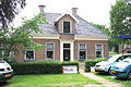 House in Diever
 -
 Market (1980)
 -
 Archaeological museum
 -
 Bull in Diever


References[edit]
- ^ a b c "Kerncijfers wijken en buurten 2021". Central Bureau of Statistics. Retrieved 12 April 2022.
- ^ "Postcodetool for 7981AA". Actueel Hoogtebestand Nederland (in Dutch). Het Waterschapshuis. Retrieved 12 April 2022.
- ^ "Informatiecentrum Diever". Nationaal park Drents-Friese wold (in Dutch). Retrieved 12 March 2022.
- ^ Ad van der Meer and Onno Boonstra, "Repertorium van Nederlandse gemeenten", KNAW, 2006. "KNAW > Publicaties > Detailpagina". Archived from the original on 20 February 2007. Retrieved 3 December 2009.
- ^ "Historisch overzicht : Shakespearetheater Diever: Toneel in de open lucht". Shakespeare Theater Diever (in Dutch). Retrieved 17 March 2020.
- ^ "Historisch overzicht : Shakespearetheater Diever: Toneel in de open lucht". Shakespeare Theater Diever (in Dutch). Retrieved 17 March 2020.
- ^ "Historisch overzicht : Shakespearetheater Diever: Toneel in de open lucht". Shakespeare Theater Diever (in Dutch). Retrieved 17 March 2020.
- ^ "Henry IV". Shakespeare Theater Diever (in Dutch). Retrieved 12 March 2022.
| International | |
|---|---|
| National | |