
Manchester Bolton & Bury Canal: Difference between revisions
m →Canal Committee: grammar |
|||
| Line 73: | Line 73: | ||
# John Pilkington, Merchant, Manchester<!--of Pilkington Manor?--> |
# John Pilkington, Merchant, Manchester<!--of Pilkington Manor?--> |
||
It was decided at this meeting that "Matthew Fletcher and Mr McNiven shall dispatch or procure 100 wheelbarrows and as many planks as they shall think necessary for the use and accommodation of the canal navigation". Further meetings with several ajournments took place on 26 July, 27 July, 28 July, and 29 July. On 30 July 1791, John Seddon of Sandy Lane was ordered to survey the line of the canal starting within the estate of John Edenson Heathcote, and ending at the southern extremity of the [[Agecroft Hall|Reverend Dauntesey's estate]]. The purpose of this survey was to value the land with a view to purchase. Matthew Fletcher was ordered to meet with any land owners to discuss purchase of any land |
It was decided at this meeting that "Matthew Fletcher and Mr McNiven shall dispatch or procure 100 wheelbarrows and as many planks as they shall think necessary for the use and accommodation of the canal navigation". Further meetings with several ajournments took place on 26 July, 27 July, 28 July, and 29 July. On 30 July 1791, John Seddon of Sandy Lane was ordered to survey the line of the canal starting within the estate of John Edenson Heathcote, and ending at the southern extremity of the [[Agecroft Hall|Reverend Dauntesey's estate]]. The purpose of this survey was to value the land with a view to purchase. Matthew Fletcher was ordered to meet with any land owners to discuss the purchase of any land along the route of the canal. Fletcher and Henshall were ordered to contact people and companies in the building trade to discuss construction of the canal.<ref name=e4418b2/> |
||
At a meeting on 16 August 1791, "several persons" attended and made offers for the contract to construct the canal. A Mr John Seddon of Little Hulton, a labourer, agreed to a contract on Matthew Fletcher's terms, for a "certain part of the canal". Five other persons were rejected by the committee, their proposals not to the "approbation" of the committee.<ref name=e4418b2/> |
At a meeting on 16 August 1791, "several persons" attended and made offers for the contract to construct the canal. A Mr John Seddon of Little Hulton, a labourer, agreed to a contract on Matthew Fletcher's terms, for a "certain part of the canal". Five other persons were rejected by the committee, their proposals not to the "approbation" of the committee.<ref name=e4418b2/> |
||
Revision as of 09:23, 9 August 2008
Template:Inland waterway under restoration
Manchester Bolton & Bury Canal | |||||||||||||||||||||||||||||||||||||||||||||||||||||||||||||||||||||||||||||||||||||||||||||||||||||||||||||||||||||||||||||||||||||||||||||||||||||||||||||||||||||||||||||||||||||||||||||||||||||||||||||||||||||||||||||||||||||||||||||||||||||||||||||||||||||||||||||||||||||||||||||||||||||||||||||||||||||||||||||||||||||||||||||||||||||||||||||||||||||||||||||||||||||||||||||||||||||||||||||||||||||||||||||||||||||||||||||||||||||||||||||||||||||||||||||||||||||||||||||||||||||||||||||||||||||||||||||||||||||||||||||||||||||||||||||
|---|---|---|---|---|---|---|---|---|---|---|---|---|---|---|---|---|---|---|---|---|---|---|---|---|---|---|---|---|---|---|---|---|---|---|---|---|---|---|---|---|---|---|---|---|---|---|---|---|---|---|---|---|---|---|---|---|---|---|---|---|---|---|---|---|---|---|---|---|---|---|---|---|---|---|---|---|---|---|---|---|---|---|---|---|---|---|---|---|---|---|---|---|---|---|---|---|---|---|---|---|---|---|---|---|---|---|---|---|---|---|---|---|---|---|---|---|---|---|---|---|---|---|---|---|---|---|---|---|---|---|---|---|---|---|---|---|---|---|---|---|---|---|---|---|---|---|---|---|---|---|---|---|---|---|---|---|---|---|---|---|---|---|---|---|---|---|---|---|---|---|---|---|---|---|---|---|---|---|---|---|---|---|---|---|---|---|---|---|---|---|---|---|---|---|---|---|---|---|---|---|---|---|---|---|---|---|---|---|---|---|---|---|---|---|---|---|---|---|---|---|---|---|---|---|---|---|---|---|---|---|---|---|---|---|---|---|---|---|---|---|---|---|---|---|---|---|---|---|---|---|---|---|---|---|---|---|---|---|---|---|---|---|---|---|---|---|---|---|---|---|---|---|---|---|---|---|---|---|---|---|---|---|---|---|---|---|---|---|---|---|---|---|---|---|---|---|---|---|---|---|---|---|---|---|---|---|---|---|---|---|---|---|---|---|---|---|---|---|---|---|---|---|---|---|---|---|---|---|---|---|---|---|---|---|---|---|---|---|---|---|---|---|---|---|---|---|---|---|---|---|---|---|---|---|---|---|---|---|---|---|---|---|---|---|---|---|---|---|---|---|---|---|---|---|---|---|---|---|---|---|---|---|---|---|---|---|---|---|---|---|---|---|---|---|---|---|---|---|---|---|---|---|---|---|---|---|---|---|---|---|---|---|---|---|---|---|---|---|---|---|---|---|---|---|---|---|---|---|---|---|---|---|---|---|---|---|---|---|---|---|---|---|---|---|---|---|---|---|---|---|---|---|---|---|---|---|---|---|---|---|---|---|---|---|---|---|---|---|---|---|---|---|---|---|---|---|---|---|---|---|---|---|---|---|---|---|---|---|---|---|---|---|---|---|---|---|---|---|---|---|---|---|---|---|---|---|---|---|---|---|---|---|---|---|---|---|---|---|---|---|---|---|---|---|---|---|---|---|---|---|---|---|---|---|---|---|---|---|---|---|---|
| |||||||||||||||||||||||||||||||||||||||||||||||||||||||||||||||||||||||||||||||||||||||||||||||||||||||||||||||||||||||||||||||||||||||||||||||||||||||||||||||||||||||||||||||||||||||||||||||||||||||||||||||||||||||||||||||||||||||||||||||||||||||||||||||||||||||||||||||||||||||||||||||||||||||||||||||||||||||||||||||||||||||||||||||||||||||||||||||||||||||||||||||||||||||||||||||||||||||||||||||||||||||||||||||||||||||||||||||||||||||||||||||||||||||||||||||||||||||||||||||||||||||||||||||||||||||||||||||||||||||||||||||||||||||||||||
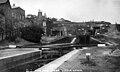
The Manchester, Bolton and Bury Canal is a derelict canal in Greater Manchester, North West England which was built to link Bolton and Bury with Manchester. The only entrance to the canal was from the River Irwell in Salford, from whereon it passed through Pendleton heading northwest to Prestolee where it branched northwest to Bolton and northeast to Bury.
The construction of the canal took place between 1791 and 1809. It was built with broad locks for a planned connection to the Leeds and Liverpool Canal which never materialised. Most of the traffic along the canal carried coal from the many collieries along its length.
As many of the collieries served by the canal reached the ends of their working lives the canal fell into disrepair and disuse before being officially abandoned in 1961. In 1987 a canal society was formed with the aim of restoring the canal for leisure use. Restoration work began in 2006, around the junction of the canal with the River Irwell, in Salford.
Features
There are several notable features along the canal, including Prestolee Aqueduct and Clifton Aqueduct, both of which are Grade II listed structures.[1][2] Nob End Locks (sometimes referred to as Prestolee Locks) sit at the junction of the three arms of the canal at Nob End. They are comprised of two sets of three staircase locks, separated by a passing basin. These locks served to lower the level of the canal by 64 feet (20 m) over a distance of 600 feet (183 m). The upper staircase is still visible, but most of the lower staircase was filled in at some point in the 1950s, and much of the stonework was removed.[3]
A major breach of the canal along the Bury arm revealed the scale of the engineering used in the construction of the retaining wall. Railway lines, which were used to increase the strength of the walls, are still clearly visible at the site of the breach.[4]
The Mount Sion steam crane (a depiction of which is used as the logo of the MB&B Canal Society) sits rusting and unused at Mount Sion, on the Bury arm. The crane was built in 1884 for Mount Sion Bleach Works by J Smith & Sons of Rodley, West Yorkshire and was used to unload coal boxes from barges into the yard below the canal.[5]
History
Proposal
A survey by Matthew Fletcher was commissioned by the citizens of Bolton in 1789 to design the proposed canal.[6] Further surveying was then carried out by Hugh Henshall – brother-in-law of James Brindley – to join the canal to the River Irwell.[6][7]
The first public notice came from Manchester on 4 September 1790, but no indication of the sponsors was given.[8] The initial proposal for the canal probably came from a group in Bolton with the support of the Mersey and Irwell Navigation.[9] A meeting was "intended to be holden at the House of Mr Shawe, the Bull's Head in Manchester aforesaid, on Monday, the twentieth day of this instant, September, at eleven o'clock in the forenoon", when "Surveys, Plans, Levels, Estimates and Proposals" would be presented.[10][11]
The proposed canal was somewhat controversial for the local industries along the route which relied on water from local rivers and brooks for their operation. At a meeting on 4 October 1790 in Bolton a resolution secured that "proper clauses be inserted in the bill to prevent injury to owners of mills".[12]
A meeting in Bury at the Eagle and Child public house on 29 September 1790 agreed that "the utility of this scheme nevertheless cannot with propriety be ascertained until such time as it has been certified, from whence and in what proportion the proprietors of the intended navigation expect to draw their resources of water".[13]
At another meeting in Bury on 13 October 1790 Hugh Henshall gave a written report on the canal and stated that his plan would not require water from the river in times of drought, but that floods and rivulets would supply his reservoirs. He suggested that mill owners could be further protected by a suitable clause in the proposed Act.[14]
Subscribers and funding

In the document "A list of subscribers to the intended Bolton Bury and Manchester Canal Navigation"[15] some of the more notable subscribers can be seen, including the amounts donated by those persons. They include:
Notable subscribers
- Earl of Derby - £3000
- Lord Grey de Wilton - £2000
- John Heathcote - £3000
- Mr Bent - £2000
- W Marsden - £1000
- John Drinkwater - £500
- Thomas hatfield and son - £1000
- Matthew Fletcher - £1500
- Ben Arthur Heywood - £600
- Nathaniel Heywood - £300
- Peter Drinkwater - £1000
- John Trafford esq - £300
- Rev James Lyon - £1000
- Ralph Fletcher for John Fletcher - £200
- James Fletcher - £200
- Thomas Lyon of Warrington - £1000
- Robert Peel - £300
- Catherine Crompton - £200
- Peter Crompton - £200
- William Crompton junior - £100
- Thomas Crompton - £100
- Ellis Crompton - £100
- John Fletcher - £200
- Hugh Henshall - £1000
Many of the 95 investments on the list appear to have been made by proxy. The largest investment is £3,000 and the smallest £100. The total sum of investments is £45,500.
Canal Committee
A committee was formed at a meeting on 30 June 1791 in Manchester at the house of Alexander Patten, comprising the following persons:[16]
- Lord Grey de Wilton, Heaton House, Lancashire
- Sir John Edenson Heathcote, Longton, Newcastle, Staffordshire
- Thomas Butterworth Bayley esq - Hope, Salford
- Robert Andrews esq - Rivington
- James Wareing, Gentleman, Knowsley
- Matthew Fletcher, Clifton
- Peter Wright, Gentleman, Manchester
- William Marsden, Merchant, Manchester
- Charles McNiven, Gentleman, Manchester
- Hugh Henshall, Longpost, Staffordshire
- John Pilkington, Merchant, Manchester
It was decided at this meeting that "Matthew Fletcher and Mr McNiven shall dispatch or procure 100 wheelbarrows and as many planks as they shall think necessary for the use and accommodation of the canal navigation". Further meetings with several ajournments took place on 26 July, 27 July, 28 July, and 29 July. On 30 July 1791, John Seddon of Sandy Lane was ordered to survey the line of the canal starting within the estate of John Edenson Heathcote, and ending at the southern extremity of the Reverend Dauntesey's estate. The purpose of this survey was to value the land with a view to purchase. Matthew Fletcher was ordered to meet with any land owners to discuss the purchase of any land along the route of the canal. Fletcher and Henshall were ordered to contact people and companies in the building trade to discuss construction of the canal.[16]
At a meeting on 16 August 1791, "several persons" attended and made offers for the contract to construct the canal. A Mr John Seddon of Little Hulton, a labourer, agreed to a contract on Matthew Fletcher's terms, for a "certain part of the canal". Five other persons were rejected by the committee, their proposals not to the "approbation" of the committee.[16]
Work begins
In 1791 the Manchester, Bolton and Bury Canal Company duly began work following a parliamentary survey of the route by Charles McNiven[17] and the passing of an Act of Parliament for the construction of the canal, by which "the proprietors were empowered to purchase land for a breadth of 26 yards (24 m) on level ground, and wider where required for cuttings or embankments."[6][18] It was intended to divide into two branches at Prestolee, with one branch heading off towards Bolton and the other to Bury, but it would not, however, join the Irwell.[6] The proprietors were entitled to take water from any brooks from within 1,000 yards (910 m) from the canal, or within 3 miles (4.8 km) of the canal summits at Bolton and Bury.[18]
A report entitled "A Statement of the Situation of the Works of the Manchester, Bolton and Bury Canal, on the Eighteenth of December, 1795." gives details of the progress of the works, including details of bridges, cuttings, raised bankings and aqueducts.[19] Much of the document details the work required to convert the canal to broad gauge. A five and three quarter mile length between Oldfield Lane in Salford and Giants Seat Locks in Outwood was navigable with three feet eight inches of water. Work remaining including strengthening the banks to increase the water depth to five feet, and gravelling of half of the towpath. Between Giants Seat locks and Ringley Bridge two locks had been erected, with a small section of canal to be broadened before becoming navigable. From Ringley Bridge to Prestolee Aqueduct one lock had been erected. Prestolee Locks was still under construction but mostly complete although the basin at the bottom was not yet dug. The stretch to Bolton had at this time been widened, with work remaining on several bridges, raising the height of embankments, constructing a weir, and gravelling of the towpath. On the Bury arm, almost the entire length had been dug, and walls constructed to support the canal along the bank of the Irwell. Some widening of previously narrow sections had yet to be undertaken, none of the towpath had yet been gravelled, and no fences had yet been erected along the towpath.
Significant parts of the construction were completed by 1796, including the stretch up to Bury in October,[6] and in the following year with the completion of the Bolton arm[20] much of the canal opened for business.
With news of the planned Rochdale Canal, the canal company proposed to extend their canal from Bury through to Littleborough, and eventually to Sladen. Intended as a rival scheme to the Rochdale Canal, despite the persistence of the canal company, the Rochdale Canal plan won the day and in 1791 the idea was abandoned.[21]
With the failure of a scheme to connect the Bolton arm of the canal to the Leeds and Liverpool Canal, the canal remained disconnected from any other waterway. One proposal thus involved the construction of an aqueduct over the River Irwell in Manchester, to connect directly to the Rochdale Canal.[22] In 1801 the bill for this aqueduct was lost, and over the following seven years the canal company purchased enough land to build a canal link directly to the Irwell.[22] The connection to Fletcher's Canal was completed in 1800. The total cost of construction was £127,700 and the first dividends were paid out to investors in 1812.[22]
Traffic
Most of the traffic along the canal transported coal from the many collieries that existed along its length, including Outwood Colliery and Ladyshore Colliery. Some of these collieries were linked by road, and some were linked by short tramlines.[23][24] In the late 19th century as much as 650,000 metric tons (640,000 long tons) of coal and 43,000 metric tons (42,000 long tons) of other materials[25] including night soil[26] and fruit[27] were transported annually. The canal also allowed the transport of salt from Cheshire, to the many bleach and dye works in the area – hence the name of Salt Wharf on the Bolton arm of the canal. Tolls were easily calculated along the canal as milestones were placed along the towpath every 1/4 of a mile. This was important as journies were often quite short, collieries being so close to industry along the canal's length.[28]
The boats used to transport coal were short and narrow, and contained several boxes filled with coal. Each box had a base of two halves, each hinged and held closed with chains. These boxes would be lifted out of the boats, positioned by crane over a bunker or cart and emptied by releasing the chains on the base. This design helped keep the canal competitive, as it increased the speed with which loading and unloading of the boats could be performed.[29]
The canal would often freeze in winter, so an icebreaker was used to break up the ice. Named "Sarah Lansdale"[30] and owned by James Crompton Paperworks, it was towed by a team of horses while the crew stood astride the deck, secured on the handrails, rocking the boat from side to side and breaking the ice in the process. The boat would often encounter ice so thick that it rose up onto the surface of the ice.[31] This boat now resides at the boat museum in Ellesmere Port Dock.[30]
Food and drink was made available to those using the canal in several places including Margaret Barlow's Tea Gardens, Kilcoby Cottage, and Rhodes Lock. A camping ground was also available at Kilcoby Cottage.[32]
The canal also carried packet services, with passengers paying a return fare of 2 shillings and 6 pence (12½ "new" pence sterling) for the three hour journey between Bolton and Manchester[33][34] The first passenger boat to Bolton was launched in 1796 from the Windsor Castle public house, and in 1798 a new packet boat was built for the use of the company.[35][11] Passengers would change boats at Prestolee to avoid delays at the lock flight and also to save water, and a purpose-built covered walkway the length of the road was installed for their benefit.[36][18][37][38] Another passenger service ran along the two arms from Bolton to Bury, and over 60,000 passengers per year travelled on the canal; between July 1833 and June 1834, 21,060 made the journey from Bolton to Manchester, 21,212 people travelled from Manchester to Bolton, and 20,818 intermediary passengers hopped on and off the boats en route.[39] In 1834 the Bolton to Manchester service earned £1,177 and the Bolton to Bury service earned £75.[40] The service was quite luxurious compared to some packet boat services: central heating was provided in winter and drinks were served on board. This caused a tragedy in 1818, however, when a party of twenty drunken passengers managed to capsize the boat. A number of passengers, including two children, were drowned.[41][42]
Several fatal incidents combined with general passenger concern caused the canal company to make safety improvements for passengers; in 1802 a wall was built at the wharf at Oldfield Lane in Salford and in 1833 a Gas Lamp was installed at Ringley Wharf.[43]
A parcel service was also offered, although this proved unpopular due to the unreliability of the service.[44]

Railway proposal
In 1830 the canal company began to promote a proposal to build a railway along the line of the canal. The company employed Alexander Nimmo for this task[45][46] and in 1831 the company obtained an Act of Parliament to become the Manchester, Bolton and Bury Canal Navigation and Railway Company.[47] When in 1832 the company obtained an Act that allowed it to build a railway, however,[48] the route did not follow the exact line of the canal and the canal remained open,[49][50] although locks 4 and 5 in Salford were moved to accommodate the new line.[22] The new line opened on 28 May 1838,[51] and was shortly followed by the cessation of passenger services on the canal. In 1846 the company was taken over by the Manchester and Leeds Railway, itself becoming the Lancashire and Yorkshire Railway the following year. In 1922 it amalgamated into the London and North Western Railway, and in 1923 this company amalgamated into the London, Midland and Scottish Railway. This company was nationalised in 1948 under the Transport Act 1947, becoming part of British Railways.
Decline
By 1924 there had been a significant reduction in the use of the Bolton arm, though the coal trade remained brisk until the 1930s when the effects of colliery closures reduced traffic.[52] Fletcher's Canal had fallen into disuse by 1935, and bank bursts alongside the Irwell and Croal rivers (caused largely by subsidence from mining activities) were common.
A major breach of the canal occurred in 1936, and this was never repaired (see Breaches). Creams Paper Mill purchased 10.45 acres (42,300 m2) of disused canal and adjacent land from the British Transport Commission around the area of the 1936 breach and built over part of the canal.[53]
On Tuesday 2 March 1937 the London, Midland and Scottish Railway held a Special General Meeting and proposed an application to the Minister of Transport to abandon a section of the canal from Clifton Aqueduct to Bailey Bridge, from Bailey Bridge to Bury, and the entire Bolton arm from Prestolee Locks to Bolton.[54] Four years later, 7 miles (11 km) of the canal were abandoned, including all of the Bolton arm. In 1939 a half-mile long section in Agecroft was ordered piped by the Ministry of Transport to reduce the risk of bomb damage to the canal affecting the adjacent Magnesium Elektron Company’s site.[55]
The canal continued to produce some revenue from the sale of water with tolls producing only a small of the canal's income. In 1946 the canal earned a total of £7,296 of which only £471 was from tolls. This was against expenses of £12,500.[56]
A little traffic south of the piped section at Agecroft continued until the early 1950s but the canal was completely abandoned in 1961 by an Act of Parliament.[57][58] A single coal delivery service between Sion Street and Bury moors continued until 1968 and was the last commercial traffic to use the canal.
Design and construction

The original source of water for the canal was from the River Irwell in Bury, at the Weddell Brook tributary. This was, however, insufficient for the needs of local industry and In 1842 Elton reservoir at Bury[59] was constructed as the principal supply for the canal.[60] Whilst the Bury and Bolton arms are on one level, the Salford arm used seventeen broad locks, including some in staircases (Nob End, for instance), to descend 190 feet (58 m) over 15.25 miles (25 km) from the summit in Bury to the lowest point at Salford.[61] Robert Fulton had proposed an inclined plane at Nob End, but this design was rejected.[62] The connection with Fletcher's Canal near Clifton Aqueduct was made with a single gated lock[63] 90 feet (27 m) long by 21 feet (6 m) wide, with a drop of 18 inches (46 cm).[64]
Although the canal was originally designed to be a narrow canal with narrow locks for boats 7 feet (2 m) in width, in 1794 an agreement was reached with the Leeds and Liverpool Canal company to create a link near Red Moss near Horwich, so broad locks were built to accommodate the 14 feet (4 m) wide boats using that canal.[65] This meant removing some of the narrow locks that had already been built.[66] An extension to the original canal feeder was built at Weddell Brook in Bury, alongside the River Irwell. The route of the Leeds and Liverpool canal was changed, however, and the planned link never materialised. Another link with the Leeds and Liverpool canal was also proposed, using a link from Bury to a location in North East Lancashire, but was rejected by the House of Lords.[67] The design changes to the canal were not completely without merit, since they allowed two boats to use each lock simultaneously saving passage time and water.
Costs
In 1795 costs of construction were detailed as follows:[19]
| Money Raised and Expended | |||
|---|---|---|---|
| Work done | £. | S. | D. |
| Original Subscription Amounts | 47,700 | 0 | 0 |
| Four calls since of ten percent | 19,080 | 0 | 0 |
| Interest allowed by the treasurer | 376 | 17 | 5 |
| Sundry Articles sold | 39 | 6 | 10 |
| Total | 67,196 | 4 | 3 |
| For obtaining the Act of Parliament, and for subsequent Law Expenses inclusive of Expenses of Meetings | 1,274 | 8 | 5 |
| Purchase of Lands | 2,586 | 7 | 8 |
| Cutting and Banking | 25,228 | 18 | 11 |
| Bricks | 5,825 | 3 | 11 3/4 |
| Masonry, Lock-Building and Walls | 8,611 | 19 | 1 1/2 |
| Bridges and Aqueducts | 8,069 | 19 | 9 1/2 |
| Timber | 4,123 | 3 | 8 |
| Iron Work | 548 | 0 | 2 1/2 |
| Wages, &c. | 1,506 | 15 | 5 1/2 |
| Damage and Trespasses | 144 | 13 | 9 |
| Team Work | 2,383 | 13 | 1 |
| Carpenters | 1,506 | 4 | 5 |
| Annual Rents | 419 | 18 | 2 |
| Surveys | 1,256 | 15 | 9 |
| Expenses of a Meeting paid by the Treasurer | 10 | 18 | 6 |
| Calls in arrear | 2,400 | 0 | 0 |
| Balance in Treasurer's Hands | 1,750 | 8 | 5 |
| Total | 67,647 | 9 | 3 3/4 |
| Deduct for Cash advanced on the above Payments included in the outstanding Debts | 451 | 5 | 0 3/4 |
| Outstanding | 67,196 | 4 | 3 |
Much of the Bury arm of the canal runs alongside the River Irwell through the Irwell Valley, and as such eventually required the construction of huge retaining walls to stop the canal bank from sliding down the hill.[68] Similar construction, although on a smaller scale, was required on the Bolton arm as it ran alongside the River Croal.[69]
Several large aqueducts were required to allow the canal to cross the River Irwell, the River Croal and two minor roads. On the Bolton arm these were Hall Lane Aqueduct, Fogg's Aqueduct and Damside Aqueduct, all of which have since been demolished. The Salford arm flowed over Prestolee Aqueduct, then Clifton Aqueduct, and finally Lumn's Lane Aqueduct (since demolished). Hall Lane Aqueduct was damaged by mining subsidence and replaced in 1884-1885 by a newer structure; this was demolished in 1950.[70]
Many bridges were also constructed along the length of the canal. Most were of small design allowing access to farmland, although many are wide enough for a horse and cart. In places where the canal crossed important thoroughfares, such as Water Street in Radcliffe, Radcliffe Road in Darcy Lever and Agecroft Road in Salford, larger bridges were constructed.
Cranes were used along the many wharfs on the canal to offload cargo. One of these, at Mount Sion, still exists (albeit in poor condition). At Bury Wharf a moving steam crane positioned between the two arms of the terminus would offload cargo to be loaded into waiting lorries.[71] A similar system was used at Radcliffe Wharf.
Breaches

During its history, the canal has suffered several major breaches. As early as 1799 a flood carried away large sections of the lower banks,[72] and another such incident occurred on 15 October 1853 when 2 boats were swept through a 93 yards (85 m) breach near the bottom of Prestolee Locks, although nobody was injured.[73] Subsidence due to mining caused a breach near Agecroft in 1881.[74]
As a result of such incidents, from 1881 to 1888 the engineer Edwin Muir was employed to undertake work to reduce damage from subsidence caused by mining activity,[75] and more work was carried out for the same purpose throughout the 1920s. Maps from the 1880s show that the canal company had purchased areas of coal beneath the canal to safeguard against further subsidence.[76]
In 1884 the Lancashire and Yorkshire Railway successfully pursued an action against the colliery owners Knowles & Sons to claim compensation for damage that subsidence caused by Knowles & Sons' mining had done to the canal. After the judgment Lancashire and Yorkshire Railway settled out of court with other colliery owners.[77]
The most serious breach occurred on 6 July 1936 at Nob End, close to Nob End locks near the junction of the three arms of the canal. This breach was never repaired, and although the canal saw continued use between Ladyshore Colliery and Bury, it eventually closed in 1961. The Manchester Evening News reported the breach on 7 July 1936:
CANAL BURSTS ITS BANKS - Barges Smashed and River Dammed "When the Bolton-Manchester Canal burst its banks at Little Lever yesterday millions of gallons of water cascaded 300 feet into the River Irwell, carrying down hundreds of tons of earth and stones. The river rapidly became blocked on the Bury side and the banked-up water flooded the surrounding land. "Like Niagara" was the description applied by one resident in the vicinity. Bricks and iron reinforcements of the side of the canal were torn away and carried into the river. Canal barges were smashed up as they too swept over the falls. Fortunately, there are no houses in the neighbourhood, and no one was hurt. It is feared that work at a paper mill and a chemical works which depend upon the canal for transport will be affected. Mr John W. Martin, of Loxham Street, Bolton, said: "I was cycling along the bank when I suddenly saw signs of a subsidence begin on a bend in the canal. I could not stop and my only chance was to ride furiously along the two feet of earth which remained. As I passed over the earth fell away behind the back wheel of my bicycle and I was thrown off. "The noise was deafening. A few yards from me tremendous quantities of water, rock, and earth were moving bodily from the canal. A gap about 100 yards long has been opened in the canal embankment. A few years ago there was a similar landslide near the spot."
Current status
Almost 60% of the original length of the canal is no longer in water.[78] Bury Wharf is now an industrial estate,[79] and the section between this wharf, and the first part of the canal still in water south of Daisyfield Viaduct, is more accessible; a car park has been built near the viaduct but there has been no further building here.[80] A small section is infilled, and the canal is in water until Water Street in Radcliffe, although strewn with weeds (see Gallery). Water Street now blocks the canal, which continues under the road through a small culvert[81] (the original bridge was demolished in the 1960s).[82] The canal remains in water up to the point where it is dammed at Ladyshore, following which an empty paper mill building, built in 1956, is found on the line of the canal.[83].
The 1936 breach, never repaired, presents a large gap in the canal route, and there is no towpath at this point. On the Salford arm, the locks at Prestolee are completely derelict although the top three locks are still in good condition.[84] The canal is in water from the bottom of these locks until it reaches Ringley Locks. Ringley Bridge is infilled, and the line of the canal is filled throughout Ringley Village, and through Giants Seat Locks.[85] Kilcoby Bridge is missing and the line of the canal is inaccessible beyond this point and up to Clifton Aqueduct. Rhodes Lock is still in reasonable condition, although completely overgrown,[84][86] and one or more electricity pylons straddle the infilled canal between Rhodes Lock and the M60 motorway, which has been built over the line of the canal. A Sludge Lagoon built during the construction of the motorway also blocks a short section of canal between the motorway and Clifton Aqueduct.[87] The canal does not take water again until past Clifton Aqueduct, where a short 900-foot (274 m) length exists between Pilkingtons and the Enersys factory. Lumn's Lane aqueduct is missing. The canal is in water between Lumn's aqueduct and Holland Street, but beyond this point the canal has been filled in and some parts built over, especially through Pendleton. The canal at the junction with the River Irwell in Salford is currently undergoing restoration.[88]
The Bolton arm of the canal is interrupted by the absence of Hall Lane Aqueduct at Little Lever. This aqueduct was demolished in 1950 to make way for widening of the road that it crossed.[89][90] In Darcy Lever, Damside aqueduct, which crossed Radcliffe Road and the Croal river, is also missing, having been demolished in June 1965.[91] The route of St Peter's Way has almost entirely destroyed a significant section of the canal as it heads into the centre of Bolton[92] and Church Wharf no longer exists.
The entire route of the canal is protected from any adverse development that would harm the restoration of the canal, having been included in the Unitary development plans of Salford City Council,[93] Bolton Council,[94] and Bury Council.[80]
Restoration
The Manchester Bolton and Bury Canal Society was formed in 1987 to protect the line of the canal and, despite the problems mentioned above, on 21 October 2005 British Waterways announced funding from European Objective Two Funding, the Northwest Regional Development Agency (NWDA) and Salford City Council for the restoration at the newly named Middlewood Locks in Salford,[88] which began in September 2006. Completion of this section is scheduled for the end of July 2008,[95] and will be marked with an opening ceremony on 19 September 2008.[96] It is hoped that the full length of the canal will eventually be restored to operation by 2020. Once restored, the canal is expected to create 6,000 jobs and add £6M to the local economy each year.[97] The locks and all of the canal at Middlewood have already been dug out and revealed for the first time in many years, with new wash walls replacing the missing stonework.[98] Asbestos was found in the infill, and there were delays to the work whilst an exemption licence to the landfill tax was applied for from HM Revenue and Customs.

"The licence has been applied for because small quantities of asbestos (less than 1%) within the material remaining mean that a separate registered disposal tip has to be used."[99] Restoration was also halted briefly by the discovery of what was initially thought to be a Second World War bomb,[100] which proved to be a wartime American mortar, but with no explosive contents.
The new Margaret Fletcher tunnel has been completed,[101][102] and will be formally named on 19 September 2008.[103] Pilings for the tunnel under the railway line have also been completed, allowing tunnelling to continue.[104] The missing Irwell towpath bridge across the canal entrance, formerly known as Bloody Bridge, is to be rebuilt as an arched timber structure, incorporating elements of the old Lock 3.[104][105] Much of the existing masonry from the canal has been re-used, including coping stones around Lock 3, and the original washwalls have been grouted and pointed where possible.[106]
The next stage of restoration will be through Salford Crescent.[107] The total cost of restoration of the canal is estimated at £60M.[108]
Local volunteers have for many years worked along sections of the canal, removing overgrowth and tidying up the general appearance,[108] and the Manchester Bolton and Bury Canal Society routinely organises working parties. The latest was held from 29–30 March 2008, and worked to clear overgrowth from Nob End Locks (see Gallery).[109] The Waterway Recovery Group also assists with this voluntary work.[110]
Gallery
-
 Map of the canal showing features, and sections with/without water.
 -
 This image shows Daisyfield Railway Viaduct, the canal flowed through the middle arch. Wellington Street is on the extreme left, visible through the archway
 -
 Blocks of stone litter the end of the canal just outside Bury town centre. This photograph is taken looking south, toward Hinds Lane. The canal bed is heavily overgrown on the centre-right of the image, the towpath is the cobbled path leading to the horizon.
 -
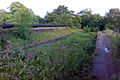
 Just outside the culvert in Radcliffe, this picture shows the level of infestation from Water Soldier (Stratiotes aloides)
 -
 The iconic Steam Crane, used as the logo for the canal society, at Mount Sion.
 -
 The 1936 breach at Nob End, today.
 -
 The local society working on the canal towpath along the short Bolton arm.
 -
 Nob End locks in operation.
 -
The bottom of Nob End Locks, looking south.
-
 Clifton Aqueduct, dry and overgrown but still accessible.
 -
 The canal between Clifton and Agecroft has a newly surfaced towpath in 2008.
 -
 The canal disappears from view along Holland Sreet, Pendlebury
 -
 Middlewood locks, April 2008, looking east into Manchester from near Oldfield Road. The canal curves around to the left, and heads underneath the railway. This section is under restoration, workmen are now digging under the railway.
 -
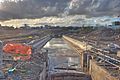 Middlewood locks, April 2008, looking west. The new base and washwalls above lock 3 have been completed and the work has progressed underneath the railway.


Locations of features
| Coordinates |
|---|
See also
- Canals of Great Britain
- History of the British canal system
- Waterway restoration
- Agecroft Colliery
- Manchester to Preston Line
References
Notes
- ^ Prestolee Aqueduct, Images of England. Retrieved on 27 June 2008.
- ^ Clifton Aqueduct, Images of England. Retrieved on 27 June 2008.
- ^ Hindle 1998, p. 3.
- ^ Hindle 1998, p. 4.
- ^ Hindle 1998, p. 4.
- ^ a b c d e Manchester Bolton and Bury Canal, Pastscape.org.uk, retrieved 2008-06-27
- ^ Paget-Tomlinson 2006, pp. 148-149.
- ^ Tomlinson 1969, p. 28.
- ^ Paget-Tomlinson 2006, pp. 148-149.
- ^ Tomlinson 1969, p. 28.
- ^ a b "Proceedings in the Business of the Intended Canal Navigation from Manchester to Bury and Bolton (1790-1831)", Manchester Mercury, 1790-09-07
{{citation}}: CS1 maint: date and year (link) - ^ Tomlinson 1969, p. 28.
- ^ Tomlinson 1969, p. 29.
- ^ Tomlinson 1969, p. 29.
- ^ A list of the subscribers to the intended Bolton Bury and Manchester Canal Navigation, Greater Manchester County Records Office, ref. E4/78/419: Manchester, Bolton and Bury Canal Company, 1791
{{citation}}: CS1 maint: location (link) - ^ a b c Manchester, Bolton and Bury Canal. Copy of resolutions, Greater Manchester County Records Office, ref. E4/4/18b/2: Manchester, Bolton and Bury Canal Company, 30 June 1791
{{citation}}: CS1 maint: location (link) - ^ Shead, Jim, Waterways Engineers and Surveyors, retrieved 2008-06-28
- ^ a b c Corbett, John (1907), The River Irwell: Pleasant Reminiscences of the Nineteenth Century, Lancashire: Heywood
- ^ a b A statement of the situation of the works of the Manchester, Bolton and Bury Canal, Greater Manchester County Records Office, ref. E4/4/18b/21: Manchester, Bolton and Bury Canal Company, 18 December 1795
{{citation}}: CS1 maint: location (link) - ^ Britton 1807, p. 35.
- ^ Tomlinson 1969, p. 33.
- ^ a b c d Brief History, retrieved 2008-06-30
- ^ Hindle 2005, p. 8.
- ^ Waterson 1985, p. 23.
- ^ The Times newspaper: Canal rates and tolls, October 18 1893
{{citation}}: Check date values in:|date=(help) Retrieved on 2008-06-29 - ^ Waterson 1985, p. 21.
- ^ Waterson 1985, p. 33.
- ^ Owen 1988, p. 60.
- ^ Owen 1988, p. 53.
- ^ a b Boat Museum Society Report (PDF), retrieved 2008-07-29
- ^ Owen 1988, p. 61.
- ^ Owen 1988, p. 55.
- ^ Tomlinson 1969, p. 101.
- ^ Uncut Fishing, retrieved 2008-06-30
- ^ Tomlinson 1969, p. 98.
- ^ Tomlinson 1969, pp. 98-99.
- ^ Britton 1807, p. 36.
- ^ Waterson 1985, p. 18.
- ^ Waterson 1985, p. 7.
- ^ Waterson 1985, p. 7.
- ^ Tomlinson 1969, p. 101.
- ^ Waterson 1985, p. 7.
- ^ Tomlinson 1969, pp. 98-99.
- ^ Tomlinson 1969, p. 102.
- ^ Significant Scots, retrieved 2008-06-28
- ^ Shead, Jim, Waterways Engineers and Surveyors, retrieved 2008-06-28
- ^ Paget-Tomlinson 2006, pp. 148-149.
- ^ Backtrack Volume 17, retrieved 2008-06-30
- ^ Paget-Tomlinson 2006, pp. 148-149.
- ^ Canal at Pendleton in 19 November 1966, retrieved 2008-06-30
- ^ Bardsley 1960, p. 7.
- ^ Paget-Tomlinson 2006, pp. 148-149.
- ^ Lyddon 1975, p. 127.
- ^ The Times newspaper: Notice of a Special General Meeting of the London, Midland and Scottish Railway, February 11 1937
{{citation}}: Check date values in:|date=(help) Retrieved on 2008-06-29 - ^ Paget-Tomlinson 2006, pp. 148-149.
- ^ Hadfield 1970, pp. 439-441.
- ^ Paget-Tomlinson 2006, pp. 148-149.
- ^ The Times newspaper: Parliamentary Notices in Parliament, Session 1960-1961, 2 December 1960 Retrieved on 2008-07-01
- ^ Waterways No.214 page 14
- ^ Paget-Tomlinson 2006, pp. 148-149.
- ^ Priestley 1831, p. 437.
- ^ Owen 1988, p. 54.
- ^ Tomlinson 1969, p. 45.
- ^ Owen 1988, p. 54.
- ^ Priestley 1831, p. 435.
- ^ Priestley 1831, p. 437.
- ^ Tomlinson 1969, p. 43.
- ^ Hindle 1998, p. 4.
- ^ Waterson 1985, p. 15.
- ^ Hindle 1998, p. 5.
- ^ Owen 1988, p. 61.
- ^ Britton 1807, p. 35.
- ^ The Times newspaper:Alarming accident on a canal, 18 October 1853 Retrieved on 2008-06-29
- ^ Hadfield 1970, pp. 439-441.
- ^ Shead, Jim, Waterways Engineers and Surveyors, retrieved 2008-06-28
- ^ Hindle 2005, p. 14.
- ^ Hadfield 1970, pp. 439-441.
- ^ The Manchester, Bolton & Bury Canal Stoppages, retrieved 2008-07-01
- ^ Bury Wharf, retrieved 2008-07-01
- ^ a b RESTORING THE MANCHESTER, BOLTON AND BURY CANAL – INITIAL POLICY AND LAND ACQUISITION ISSUES (DOC), Bury Council, 12 February 2003, retrieved 2008-06-27
- ^ Water Lane, retrieved 2008-07-01
- ^ Water Street Bridge over Canal, retrieved 2008-07-01
- ^ Lyddon 1975, p. 127.
- ^ a b Bury, Bolton, Manchester Canal. Manchester Arm, retrieved 2008-07-01
- ^ Giants Seat Locks, retrieved 2008-06-30
- ^ Rhodes Lock, retrieved 2008-06-30
- ^ M60 Motorway (M62), retrieved 2008-06-30
- ^ a b Full Steam Ahead For Canal Restoration In Salford, British Waterways, retrieved 2008-06-27
- ^ Farnworth/Moses Gate - ben200525671.jpg, retrieved 2008-06-30
- ^ Hall Lane Aqueduct, retrieved 2008-06-30
- ^ Damside Aqueduct, retrieved 2008-06-30
- ^ The Bolton Arm, retrieved 2008-07-01
- ^ City of Salford Unitary Development Plan 2004 - 2016, Salford City Council, retrieved 2008-06-27
- ^ Unitary Development plan for Bolton (PDF), Bolton Council, April 2005, retrieved 2008-06-27
- ^ Littlewood 2008, p. 5.
- ^ Fletcher 2008, p. 3.
- ^ Canal may be re-born, BBC Online, 2002-05-28, retrieved 2008-06-27
- ^ Jackson 2007, p. 6.
- ^ Jackson 2007, p. 6.
- ^ Littlewood 2007, p. 5.
- ^ "Restoration Report". Retrieved 2008-06-28.
- ^ Middlewood Locks Project
{{citation}}: Unknown parameter|access date=ignored (|access-date=suggested) (help) - ^ Fletcher 2008, p. 3.
- ^ a b Littlewood, Fran, Middlewood Progress, Manchester, Bolton and Bury Canal Society, retrieved 2008-06-27
- ^ Littlewood, 2008 & pp5-8.
- ^ Littlewood 2008, p. 5.
- ^ Parry 2007, p. 6.
- ^ a b Qureshi, Yakub (2007-08-02). "Army gives canal clean-cut look". M.E.N. media 2008. Retrieved 2008-06-27.
- ^ "Working Parties: 29 - 30 March 2008". Retrieved 2008-06-28.
- ^ WRGNW - Manchester Bolton & Bury Canal - Prestolee, Michael Chase, 2008
Bibliography
- Bardsley, James Rodney (1960), The railways of Bolton, 1824-1959, J.R.Bardsley, ASIN B0000CKNFN.
- Britton, John (1807), The Beauties of England and Wales; or Deliniations, Topographical, Historical and Descriptive
- Fletcher, John (2008), Manchester Bolton and Bury Canal Society newsletter, Eric Moore & Co, Albert Close Trading Estate, Whitefield, Manchester
- Hadfield, Charles (1970), The canals of northwest england volume 2, David and Charles limited, ISBN 0715349929
{{citation}}: Unknown parameter|coauthors=ignored (|author=suggested) (help) - Hindle, Paul (1998), Exploring Greater Manchester (PDF), Paul Hindle, Manchester Geographical Society
- Hindle, Paul (2005), The Tram Roads of the Manchester, Bolton and Bury Canal (PDF), Paul Hindle
- Jackson, Mike (2007), Manchester Bolton and Bury Canal Society newsletter, Eric Moore & Co, Albert Close Trading Estate, Whitefield, Manchester
- Littlewood, Fran (2007), Manchester Bolton and Bury Canal Society newsletter, Eric Moore & Co, Albert Close Trading Estate, Whitefield, Manchester
- Littlewood, Fran (2008), Manchester Bolton and Bury Canal Society newsletter, Eric Moore & Co, Albert Close Trading Estate, Whitefield, Manchester
- Lyddon, Dennis (1975), Paper in Bolton, A Papermaker's Tale, Bolton Central Library, UK: Sherratt for Trinity Paper Mills Ltd, ISBN 0854270434
{{citation}}: Unknown parameter|coauthors=ignored (|author=suggested) (help) - Owen, David Elystan (1988), Canals to Manchester, Manchester University Press, ISBN 0719026318
- Paget-Tomlinson, Edward (2006), The Illustrated History of Canal & River Navigations 3rd edition, Ashbourne, UK: Landmark Publishing Ltd, ISBN 1843062070
- Parry, Dilwyn (2007), Manchester Bolton and Bury Canal Society newsletter, Eric Moore & Co, Albert Close Trading Estate, Whitefield, Manchester
- Priestley, Joseph (1831), Historical Account of the Navigable Rivers, Canals, and Railways of Great Britain, Longman, Green
- Tomlinson, V I (1969), The Manchester Bolton And Bury Canal Navigation 1790 - 1845, Bolton Central Library, UK: Lancashire And Cheshire Antiquarian Society, ASIN B00165SCDA
- Waterson, Alec (1985), On the Manchester, Bolton and Bury Canal, Bolton Central Library, UK: Neil Richardson, ISBN 0907511791
External links
- 1850 overlay of the entire canal for Google Earth
- Manchester Bolton and Bury canal society
- Pennine Waterways - Manchester Bolton and Bury Canal
- Dave Lane home page, includes information about Fletcher's Canal
- Steven Parker's canal journeys part 1
Images of canal, external sites
- Image of canal entrance at River Irwell 1909
- Image of canal at Darcy Lever 1960s a
- Image of canal at Darcy Lever 1960s b
- 2 Images of the canal at Darcy Lever
- Image of canal at Ringley, being infilled under bridge
- Image of canal breach 1936
- Image of canal breach 1936, lower down
- Image of canal at entrance to River Irwell 1901