River Irwell
| River Irwell | ||
| Data | ||
| location | Lancashire and Greater Manchester , England | |
| River system | River Mersey | |
| Drain over | River Mersey → Irish Sea | |
| source | Irwell Springs, Parish Cliviger 53 ° 43 ′ 54 " N , 2 ° 11 ′ 49" W. |
|
| Source height | 400 m | |
| muzzle | as part of the Manchester Ship Canal at Irlam in the River Mersey Coordinates: 53 ° 26 ′ 16 " N , 2 ° 24 ′ 48" W 53 ° 26 ′ 16 " N , 2 ° 24 ′ 48" W
|
|
| length | 63 km | |
| Big cities | Manchester | |
| Medium-sized cities | Salford | |
|
The Barton Swing Aqueduct |
||
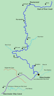
The River Irwell is a 63 km long river that flows through the Irwell Valley in northwest England in the counties of Lancashire and Greater Manchester .
The source of the river is Irwell Springs on Deerplay Moor, about 2.5 km north of the town of Bacup , in the parish of Cliviger , Lancashire. The River Irwell flows through downtown Manchester and Salford before joining the River Mersey near Irlam .
In order to make the winding course of the river easier for ships to navigate and to create a connection to the River Mersey , the Mersey and Irwell Navigation was built in the 18th century , followed by the larger and still operated Manchester Ship at the end of the 19th century Canal lost its role in connecting Manchester to Liverpool and the open seas.
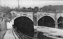
The River Irwell is crossed by the Bridgewater Canal , which was possible between 1761 and 1891 using the Barton Aqueduct and has since been realized by the Barton Swing Aqueduct , and also by the Trinity Bridge (Greater Manchester) .


