Kangaroo Island

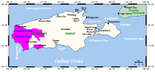
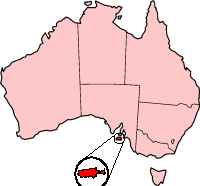
Kangaroo Island is Australia's third largest island - after Tasmania and Melville Island. It is 112 kilometres southwest of Adelaide at the entrance of Gulf Saint Vincent. At its closest point to the mainland, it is 13 kilometres offshore from Cape Jervis, on the tip of the Fleurieu Peninsula in the state of South Australia. The island is 150 km long and between 900 m and 57 km wide, its area covering 4 405 km² (about 1,700 square miles). Its coastline is 540 km long and highest altitude is 307 m.

History
Kangaroo Island was separated from mainland Australia by a rise in sea level about 9,000 years ago. Stone tools found suggest that Aboriginal people occupied the land at least 11,000 years ago; it is supposed that they disappeared in 200 BC. Theories about the cause include disease and inbreeding, warfare, climatic change or exodus.
In 1802 British explorer Matthew Flinders named the land "Kanguroo" Island, after landing near Kangaroo Head on the north coast of Dudley Peninsula. He was closely followed by the French explorer Nicolas Baudin, who mapped much of the island (which is why so many areas have French names). Although the French and the English were at war at the time, the men met peacefully. They both used the fresh water seeping at what is now known as Hog Bay near Frenchman's Rock; the community is now called Penneshaw.
An unofficial community of sealers and others was set up on Kangaroo Island from 1802 to the time of South Australia's official settlement in 1836. The sealers were rough men and several kidnapped Aboriginal women from Tasmania and mainland South Australia. The women were forced to do the work of sealers, amongst other activities. Three Aboriginal women tried to escape and swim back to the mainland; one is on record as having survived the journey.
The biggest town on Kangaroo Island is Kingscote. Originally established at Reeves Point on 27 July 1836, it is South Australia's first official European settlement. It was later suggested that Kingscote could serve as the capital of South Australia, but the island's resources were insufficient to support such a large community, so the settlement of Adelaide was chosen.
Population and Economy
About 4,400 inhabitants live on the island, 1,800 of them in Kingscote in 2001. The economy is mostly agricultural (wine, honey, wool, meat and grain). Tourism and fishing also play significant roles.
Kangaroo island is famous for its honey and for being the oldest bee sanctuary in the world. Ligurian bees were imported from the Italian province of Liguria in 1881, and Kangaroo Island now has the only pure strain in the world.
Wildlife and its protection
More than half of the island has never been cleared of vegetation. About one-third of it is conserved in National and Conservation Parks, including five Wilderness Protection Areas. The main protected areas are:
- Flinders Chase National Park
- Seal Bay Conservation Park
- Cape Gantheaume Wilderness Protection Area
- Cape Bouguer Wilderness Protection Area
- Ravine des Casoars Wilderness Protection Area
Because of its isolation from mainland Australia, foxes and rabbits are absent from the island. The Kangaroo Island Kangaroo, Rosenberg's Sand Goanna, Southern Brown Bandicoot, Tammar Wallaby, Common Brushtail Possum, Short-beaked Echidna and New Zealand Fur Seal are native to the island, as well as six bat and frog species. The sole endemic (found nowhere else) vertebrate species is a small marsupial carnivore called the Kangaroo Island Dunnart. The Koala, Common Ringtail Possum and Platypus have been introduced and still survive there. Kangaroo Island had a native species of Emu, the Kangaroo Island Emu; however, it became extinct between 1802 and official European settlement in 1836, perhaps owing to bushfires or from hunting by sealers or whalers.
The introduced Koalas have flourished on the island, to the degree that their preferred food source, the Manna Gum, is currently at risk of extinction. Koalas have recently been forced to turn to other, less palatable, species. Management methods used include surgical sterilisation and transfer to suitable empty mainland sites. This does not appear to be keeping up with the breeding rate, though, so the only practical solution may be culling. The government is opposed to this though, fearing an economic backlash through tourism boycotts.
Kangaroo Island is the last South Australian refuge of the endangered Glossy Black Cockatoo. A list of birds recorded on Kangaroo Island can be found in the List of the birds of Kangaroo Island, South Australia.
Tourism

General Tourist Information is located in Penneshaw, Howard Drive and open 7 days a week.
Places of interest

- Seal Bay with ranger guided walks among basking Australian sea lions.
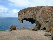
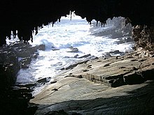
- Flinders Chase National Park which includes the Remarkable Rocks, Admiral's Arch, lighthouses at Cape Borda and Cape du Couedic and multiple walking trails and camping areas.
- Cape Willoughby.
- Kelly Hill Caves with guided cave tours.
- Little Sahara, huge sand dunes on the south coast.
- the lookout Mount Thisby (officially designated Prospect Hill in 2002 to honour Matthew Flinders's original naming) with a 360 degree view around the island.
- Murray Lagoon with its abundant aquatic bird life.
Restrictions
For quarantine reasons it is prohibited to bring honey products and bee-handling equipment to the island. Potatoes brought to the island must be in new packaging and vine cuttings and soil in which grapevines have grown are not to be brought without prior inspection. Rabbits and Foxes are not permitted on the island. Shoes must be dusted when entering some national and conservation parks to prevent the spread of fungi. Campfires are not permitted within national parks.
Lifestyle

Safe swimming is possible on the northern beaches, such as Emu Bay, Stokes Bay or Snelling Beach. The south coast has dangerous undertows and is not safe for swimming because of risk of sharks attracted by the sea lion and fur seal colonies that are situated there.
Camping is permitted in approved local government camping areas, designated areas within National Parks and caravan parks. In other areas it is prohibited.
Accommodation can be found all across the island and should be booked in advance.
Shops and petrol stations can be found in the major towns: Kingscote, Parndana, American River, Penneshaw (once called Hog Bay) and Vivonne Bay. Basic trading hours are Monday to Friday 9 a.m. to 5.30 p.m. and Saturday 9 a.m. to noon although many shops open longer. Visitors should be aware that it can be difficult to find petrol after about 6pm.
The Australian banks ANZ and Bank SA have branches in Kingscote and Commonwealth Bank has an agency at the Kingscote and Penneshaw Post Offices. Automatic teller machines (ATM) are situated in Kingscote, American River, Penneshaw and Parndana. Major credit cards are accepted in most places.

Connections to Kangaroo Island
Access to the island is by sea ferry across Backstairs Passage from Cape Jervis to Penneshaw, which takes about 50 minutes, or by air from Adelaide to Kingscote. Regional Express airlines have several return flights per day.
Climate
The winters between June and September are mild and wet, the summers usually warm and dry. Tempered by the ocean, particularly on the coastline, maximum temperatures in summer rarely exceed 35 degrees celsius. Average temperatures in August range between 13 to 16 degrees and in February, the hottest month, between 20 and 25 degrees. Between May and September the island receives 2/3 of its annual rainfall, varying from 450 mm in Kingscote to around 900 mm near Roo Lagoon on the top of the central plateau. The wettest month is July.

- Average Annual Temperature: 11.6 - 19.1°C
- Average January Temperature: 14.9 - 23.6°C
- Average July Temperature: 8.4 - 14.6°C
- Days over 30°C: 10.3
- Days over 35°C: 1.6
- Days under 2°C: 0.3
- Days under 0°C: 0.0
- Annual Rainfall: 485.1 mm
- Average Annual Windspeed: 14.7 - 17.7 km/h
See also

External links
- Tour Kangaroo Island
- Sealink Cape Jervis to Penneshaw ferry service.
- Rebe Taylor, Unearthed: The Aboriginal Tasmanians of Kangaroo Island, Kent Town, Wakefield Press, 2002 ISBN 1-86254-552-9
- Reference to commentary in The Advertiser of 13 December 2002 p. 19
- ABC Radio National, Hindsight program broadcast 22/02/2004
- Template:Wikitravel
