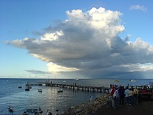
Kangaroo Island
| Kangaroo Island | ||
|---|---|---|
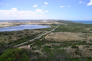
| View over the eastern part of the island from a sand mountain at its narrowest point | ||
| Waters | Gulf Saint Vincent ( Indian Ocean ) | |
| Geographical location | 35 ° 50 ′ S , 137 ° 16 ′ E | |
|
|
||
| length | 145 km | |
| width | 56 km | |
| surface | 4th 405 km² | |
| Highest elevation | Prospect Hill 307 m |
|
| Residents | 4700 (2016) 1.1 inhabitants / km² |
|
| main place | Kingscote | |
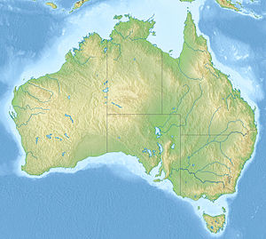
| Map of the island | ||
Kangaroo Island (German Kangaroo Island , earlier spelling Kangaroo Island ) is the third largest island in Australia after Tasmania and Melville Island . It is 112 kilometers southwest of Adelaide in the Gulf of Saint Vincent in the state of South Australia .
geography
location
The island is 145 kilometers long, between 900 meters and 57 kilometers wide and has 509 kilometers of coastline. It is Australia's third largest island with an area of 4,405 square kilometers. The highest peaks are on the plateau of the north coast at 307 meters above sea level.
The island is located 13 kilometers from the coast and Cape Jervis at the tip of the Fleurieu Peninsula and is separated from it by the Backstairs Passage.
climate
The winters between June and September are mild and humid, the summers usually warm and dry. Due to its location in the Indian Ocean, temperatures above 35 ° C are rarely reached in summer, especially along the coast. The average maximum temperature in August is 16 ° C and in February, the hottest month of the year, between 26 and 27 ° C. 2/3 of the annual precipitation falls between May and September. This varies between 450 mm in Kingscote and 1000 mm in Gosse. The wettest month is July.
|
Average monthly temperatures for Kingscote
Source: Bureau of Meteorology, Australia, data: 1994–2010
|
population
Around 4,700 people live on the island (as of 2016) . The island forms its own administrative area, the District Council of Kangaroo Island .
history
The island was separated from mainland Australia by sea level rise about 10,000 years ago . The finds of stone tools suggest that this part of Australia was settled 11,000 years ago. It is currently believed that the indigenous people of the time were around 200 BC. Chr. Disappeared. The reason for this is suspected to be diseases, tribal feuds, climate change or emigration.
In 1802, British explorer Matthew Flinders named the island Kangaroo Island after disembarking near Kangaroo Head on the north coast of the Dudley Peninsula. The following year Nicolas Baudin arrived on his expedition from 1800-1804 on the island.
As a result, a small community of former seal hunters developed on the island . The feral men forcibly abducted Aboriginal women from Tasmania and the mainland to their island. Over time, they built houses and became successful farmers.
Kingscote, the largest town on the island, is the first settlement officially established by Europeans in South Australia . It was founded on July 27, 1836 at Reeves Point. After just a few months, the newcomers moved to Adelaide , where more land and resources were available.
After large areas burned down in bushfires in 2007 , serious fires again raged in the west of the island in early January 2020, destroying around a third of the island. Two people and thousands, some of them rare animals, fell victim to the flames, as well as houses, hotels and tourist infrastructure.
economy
The island is largely agricultural. Economic goods are wine, honey, wool, meat and grain. In addition, fishing and, increasingly, ecotourism play a role.
Kangaroo Island is famous for its honey ; it is one of the oldest bee sanctuaries (since 1881).
traffic
The island can be reached in 30 minutes by plane from Adelaide , the capital of South Australia. A small airport ( IATA code : KGC) is located southwest of Kingscote. The Sealink car ferry operates between Cape Jervis and Penneshaw. The crossing takes about 50 minutes. In 2007 and 2008 there was a car ferry called the Kangaroo Island Ferry from Wirrina Cove to Kingscote.
Animals and protected areas
Over half of the island has retained its lush original vegetation. National parks and protected areas, which include five game reserves, have been designated for more than a third of the island's area.
The largest protected areas are:
- Flinders Chase National Park
- Sealbay Conservation Park
- Cape Gentheaume Wilderness Protection Area
- Cape Bouguer Wilderness Protection Area
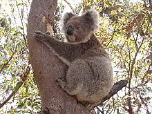
Due to its isolation from the mainland, there are no foxes and rabbits on the island . The derby wallaby , the black kusu and the short-billed hedgehog are native to the island, as are six bat and frog species , while the shores of the little penguin , New Zealand and Australian fur seals and Australian sea lions live on the coast . The brown-headed cockatoo is also part of the island's avifauna . The endemic kangaroo island emu ( Dromaius baudinianus ) has become extinct. Koalas , Ringbeutler and platypus were settled on the island and have become native. The koalas have now multiplied so much that contraceptives are used to stop the population from growing further, otherwise there would be a risk that not enough food would be available.
The seahorse-related fish species live in the sea, the large sea fish and the small sea fish .
Attractions
- Seal Bay Conservation Park : Sea lion reserve with around 700 animals on the south coast (55 km SW Kingscote). Rangers guide visitors through the colony.
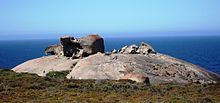
- Flinders Chase National Park : National park on the southwest tip of the island (103 km SW Kingscote). The rock formations Remarkable Rocks and the Admirals Arch at Cape du Couedic, which is home to a colony of New Zealand fur seals, are among theisland's main attractions. The park is also famous for the lighthouses of Cape Borda and Cape du Couedic as well as koalas, particularly trusting wild kangaroos and numerous other animals.
- Lighthouse at Cape Willoughby
- Kelly Hill Caves with guided cave tours
- Little Sahara ( Little Sahara ): Formation of huge sand dunes on the south coast
- Mount Thisby / Prospect Hill : Viewpoint with a 360-degree island panorama
- Little penguins on the Kingscote and Penneshaw coasts where wildlife service tours of the nesting area are offered after sunset .
- Murray Lagoon: Moor lakes on the south coast (50 km SW Kingscote) that are home to many marsh birds
Restrictions
Due to quarantine regulations, it is forbidden to bring honey products and beekeeping equipment to the island. Potatoes that are imported must be in their original packaging. Grapevine clippings and soil from vines must be reported to the local quarantine office. Rabbits are not allowed on the island.
leisure
Swimming is relatively safe in the bays of the north coast such as Emu Bay, Stokes Bay or Snelling Beach. The south coast is not recommended for swimming due to dangerous undercurrents and the shark attacks on the sea lion colony.
Camping is permitted on the designated tent sites, caravan parks or bush camps in the national parks , otherwise prohibited. The range of accommodation is richly distributed over the entire island, but should be booked before arrival.
Shops and gas stations can be found in the larger towns of Kingscote, Parndana, American River, Penneshaw (formerly Hog Bay) and Vivonne Bay.
Web links
Individual evidence
- ↑ Bureau of Meteorology, Australia: Klimainformationen Kingscote. World Meteorological Organization, accessed June 7, 2012 .
- ↑ 2016 Census QuickStats | Kangaroo Island (DC). Australian Bureau of Statistics , accessed January 13, 2020 .
- ↑ Tony Love: Colonial History; In the beginning . In: The Advertiser . December 13, 2002, p. 19 ( Copy on History News Network ( February 2, 2009 memento on the Internet Archive )).
- ↑ Mitch Mott, Paul Purcell, Josephine Lim: Quarter of KI ravaged as 'worst nightmare comes true'. In: The Advertiser. January 3, 2020, accessed on January 7, 2020 .
- ↑ Emily Olle: Two confirmed dead on Kangaroo Island as bushfires rage across the tourist spot. In: 7News.com.au. January 4, 2020, accessed on January 7, 2020 .
- ↑ Bushfires take a devastating toll on 'Australia's Galapagos Islands'. In: The Sydney Morning Herald. January 5, 2020, accessed on January 7, 2020 .
