Marianao: Difference between revisions
MpueblaYara (talk | contribs) No edit summary |
Afus199620 (talk | contribs) No edit summary |
||
| (26 intermediate revisions by 22 users not shown) | |||
| Line 2: | Line 2: | ||
<!--See the Table at Infobox Settlement for all fields and descriptions of usage--> |
<!--See the Table at Infobox Settlement for all fields and descriptions of usage--> |
||
<!-- Basic info ----------------> |
<!-- Basic info ----------------> |
||
| |
| name = |
||
| |
| official_name = Marianao |
||
| |
| other_name = |
||
| |
| native_name = |
||
|nickname = |
| nickname = |
||
|settlement_type = [[Municipalities of Havana|Municipality]] of [[Havana]] |
| settlement_type = [[Municipalities of Havana|Municipality]] of [[Havana]] |
||
|motto = |
| motto = <!-- images and maps -----------> |
||
| image_skyline = ElObelisco.jpg |
|||
<!-- images and maps -----------> |
|||
| |
| imagesize = |
||
| |
| image_caption = "El Obelisco", Carlos J. Finlay Memorial |
||
| image_map = Havana Map - Marianao.png |
|||
|image_caption = "El Obelisco", Carlos J. Finlay Memorial |
|||
| |
| mapsize = |
||
| |
| map_caption = Location of Marianao in Havana |
||
| |
| pushpin_map = <!-- Cuba --> |
||
| |
| pushpin_label_position = bottom |
||
| ⚫ | |||
|pushpin_label_position = bottom |
|||
| ⚫ | |||
| ⚫ | |||
| |
| subdivision_type = Country |
||
| subdivision_name = {{flag|Cuba}} |
|||
| ⚫ | |||
| ⚫ | |||
|coordinates_region = CU |
|||
| ⚫ | |||
|subdivision_type = Country |
|||
| |
| subdivision_type2 = |
||
| ⚫ | |||
| ⚫ | |||
| ⚫ | |||
| ⚫ | |||
| |
| government_type = |
||
| |
| leader_title = |
||
| ⚫ | |||
| ⚫ | |||
| ⚫ | |||
| ⚫ | |||
| |
| leader_name1 = |
||
| |
| established_title = |
||
| |
| established_date = |
||
| |
| established_title2 = <!-- Incorporated (town) --> |
||
| ⚫ | |||
|leader_name1 = |
|||
| |
| area_magnitude = |
||
| |
| unit_pref = |
||
| ⚫ | |||
|established_title2 = <!-- Incorporated (town) --> |
|||
| |
| area_total_km2 = 22 |
||
| ⚫ | |||
| ⚫ | |||
| area_water_km2 = <!-- Population -----------------------> |
|||
|area_magnitude = |
|||
| |
| population_as_of = 2022 |
||
| population_footnotes = |
|||
| ⚫ | |||
| |
| population_note = |
||
| ⚫ | |||
| ⚫ | |||
| |
| population_density_km2 = auto |
||
<!-- |
<!-- General information --------------->| timezone = [[Eastern Time Zone|EST]] |
||
| |
| utc_offset = -5 |
||
| timezone_DST = |
|||
|population_footnotes = <ref name=atenas>{{Cite web| url=http://www.atenas.inf.cu/todo/Estadisticas/TABLA%20No_3balance.htm| title=2004 Population trends, by Province and Municipality| author= Atenas.cu| year= 2004| accessdate=2007-10-06 |archiveurl = http://web.archive.org/web/20070927111826/http://www.atenas.inf.cu/todo/Estadisticas/TABLA+No_3balance.htm |archivedate = 2007-09-27|language=es}}</ref> |
|||
| |
| utc_offset_DST = |
||
| coordinates = {{coord|23|05|0|N|82|26|0|W|region:CU|display=inline,title}} |
|||
| ⚫ | |||
| ⚫ | |||
|population_density_km2 = 6272 |
|||
| ⚫ | |||
<!-- General information ---------------> |
|||
| |
| postal_code_type = |
||
| |
| postal_code = |
||
| |
| area_code = +53-7 |
||
| ⚫ | |||
|utc_offset_DST = |
|||
| parts_style = para |
|||
|latd= 23|latm= 05|lats= 0|latNS=N |
|||
| p1 = [[CAI-Los Ángeles]] |
|||
|longd= 82|longm= 26|longs= 0|longEW=W |
|||
| p2 = [[Libertad, Havana|Libertad]] |
|||
|coordinates_display = inline,title |
|||
| p3 = [[Pocito-Palmas]] |
|||
| ⚫ | |||
| |
| p4 = [[Pogoloti-Belén-Finlay]] |
||
| p5 = [[Santa Felicia]] |
|||
| ⚫ | |||
| p6 = [[Zamora-Cocosolo]] |
|||
|postal_code_type = |
|||
| |
| website = |
||
| |
| footnotes = |
||
| ⚫ | |||
|p1 = [[CAI-Los Ángeles]]|p2 = [[Libertad, Havana|Libertad]]|p3 = [[Pocito-Palmas]]|p4 = [[Pogoloti-Belén-Finlay]]|p5 = [[Santa Felicia]]|p6 = [[Zamora-Cocosolo]] |
|||
| ⚫ | |||
| ⚫ | |||
}} |
}} |
||
'''Marianao''' is one of the 15 municipalities or boroughs (''[[municipio]]s'' in Spanish) in the city of [[Havana]], [[Cuba]]. It lies 6 miles southwest of the original city of Havana, with which it is connected by the Marianao [[railway]]. In |
'''Marianao''' is one of the 15 municipalities or boroughs (''[[municipio]]s'' in Spanish) in the city of [[Havana]], [[Cuba]]. It lies 6 miles southwest of the original city of Havana, with which it is connected by the Marianao [[railway]]. In 2022 the municipality had a population of 134,057.<ref name="citypopulation">{{Cite web |title=Cuba: Administrative Division (Provinces and Municipalities) - Population Statistics, Charts and Map |url=https://www.citypopulation.de/en/cuba/admin/ |access-date=2024-02-03 |website=www.citypopulation.de}}</ref> Marianao is on a range of hills of about 1500 above [[sea level]] and is noted for its salubrious [[climate]].<ref>Encyclopædia Britannica</ref> The city dates back to 1830. |
||
==Overview== |
==Overview== |
||
As Havana expanded during the 1930s and 1940s, Marianao became a suburb of the city. |
As Havana expanded during the 1930s and 1940s, Marianao became a suburb of the city. |
||
A famous landmark is the monument built to honor [[Carlos Finlay|Carlos Juan Finlay]] |
A famous landmark is the monument built to honor [[Carlos Finlay|Carlos Juan Finlay]], a doctor who helped eradicate [[yellow fever]] in Cuba in the 19th century. It is shaped like a syringe. The monument is at the junction of Calles 100 and 31, close to several major hospitals.{{citation needed|date=May 2018}} |
||
Marianao is home to the famous [[Tropicana Club]] and was home to the [[Oriental Park Racetrack]]. |
Marianao is home to the famous [[Tropicana Club]] and was home to the [[Oriental Park Racetrack]]. |
||
One of the most notable foods |
One of the most notable foods made in Marianao is "Pollo A La Barbacoa". |
||
==Personalities== |
==Personalities==<!-- New links in alphabetical order please --> |
||
*[[Alicia Alonso]], [[prima ballerina assoluta]] |
|||
| ⚫ | |||
| ⚫ | |||
*[[Maria Teresa, Grand Duchess of Luxembourg]], spouse of the current Grand Duke of Luxembourg |
*[[Maria Teresa, Grand Duchess of Luxembourg]], spouse of the current Grand Duke of Luxembourg |
||
| ⚫ | |||
*[[Jorge Enrique González Pacheco]], poet and cultural entrepreneur |
*[[Jorge Enrique González Pacheco]], poet and cultural entrepreneur |
||
| ⚫ | |||
==Twin towns== |
==Twin towns== |
||
*{{flagicon|Mexico}} '''[[Carmen Municipality|Carmen]]''' ([[Campeche]], [[Mexico]]) |
*{{flagicon|Mexico}} '''[[Carmen Municipality|Carmen]]''' ([[Campeche]], [[Mexico]]) |
||
*{{flagicon|Mexico}} '''[[Zapopan, Jalisco|Zapopan]]''' ([[Jalisco]], [[Mexico]])http://www.zapopan.gob.mx/soy-turista/relaciones-internacionales/ |
*{{flagicon|Mexico}} '''[[Zapopan, Jalisco|Zapopan]]''' ([[Jalisco]], [[Mexico]])<ref>{{cite web |url=http://www.zapopan.gob.mx/soy-turista/relaciones-internacionales/ |title=Relaciones Internacionales {{!}} Gobierno Municipal de Zapopan 2010 - 2011 |website=www.zapopan.gob.mx |url-status=dead |archive-url=https://web.archive.org/web/20110925163902/http://www.zapopan.gob.mx/soy-turista/relaciones-internacionales/ |archive-date=2011-09-25}} </ref><ref>Asuntos Internacionales y Ciudades Hermanas</ref> |
||
<ref>Asuntos Internacionales y Ciudades Hermanas</ref> |
|||
==References== |
==References== |
||
| Line 98: | Line 93: | ||
==External links== |
==External links== |
||
{{Commons category}} |
|||
{{Portal|Cuba}} |
{{Portal|Cuba}} |
||
| ⚫ | |||
{{commonscat-inline|Marianao}} |
|||
| ⚫ | |||
*[http://www.cibercuba.com/lecturas/el-obelisco-de-marianao-se-encuentra-en-la-plaza-carlos-j-finlay El Obelisco de Marianao] |
*[http://www.cibercuba.com/lecturas/el-obelisco-de-marianao-se-encuentra-en-la-plaza-carlos-j-finlay El Obelisco de Marianao] |
||
*[http://www.lenzayas.com/Marianao/Marianao.htm Description of Marianao before the 1959 Revolution] |
*[https://web.archive.org/web/20090916204608/http://www.lenzayas.com/Marianao/Marianao.htm Description of Marianao before the 1959 Revolution] |
||
{{Adjacent communities |
|||
| Centre = Marianao |
|||
| N = [[Playa, Havana|Playa]] |
|||
| NE = [[Plaza de la Revolución]] |
|||
| E = [[Cerro, Havana|Cerro]]<br />[[Boyeros]] |
|||
| S = [[Boyeros]] |
|||
| W = [[La Lisa]] |
|||
}} |
|||
{{Havana municipalities}} |
{{Havana municipalities}} |
||
{{ |
{{Authority control}} |
||
[[Category:Municipalities of Havana]] |
[[Category:Municipalities of Havana]] |
||
Latest revision as of 19:05, 3 February 2024
Marianao | |
|---|---|
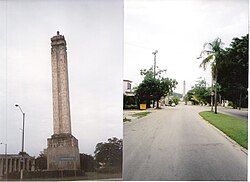
 "El Obelisco", Carlos J. Finlay Memorial | |
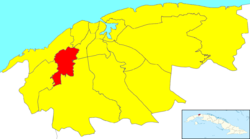
 Location of Marianao in Havana | |
| Coordinates: 23°05′0″N 82°26′0″W / 23.08333°N 82.43333°W | |
| Country | |
| Province | |
| Wards (Consejos Populares) | CAI-Los Ángeles, Libertad, Pocito-Palmas, Pogoloti-Belén-Finlay, Santa Felicia, Zamora-Cocosolo |
| Area | |
| • Total | 22 km2 (8 sq mi) |
| Population (2022) | |
| • Total | 134,057 |
| • Density | 6,100/km2 (16,000/sq mi) |
| Time zone | UTC-5 (EST) |
| Area code | +53-7 |
Marianao is one of the 15 municipalities or boroughs (municipios in Spanish) in the city of Havana, Cuba. It lies 6 miles southwest of the original city of Havana, with which it is connected by the Marianao railway. In 2022 the municipality had a population of 134,057.[2] Marianao is on a range of hills of about 1500 above sea level and is noted for its salubrious climate.[3] The city dates back to 1830.
Overview[edit]
As Havana expanded during the 1930s and 1940s, Marianao became a suburb of the city.
A famous landmark is the monument built to honor Carlos Juan Finlay, a doctor who helped eradicate yellow fever in Cuba in the 19th century. It is shaped like a syringe. The monument is at the junction of Calles 100 and 31, close to several major hospitals.[citation needed]
Marianao is home to the famous Tropicana Club and was home to the Oriental Park Racetrack. One of the most notable foods made in Marianao is "Pollo A La Barbacoa".
Personalities[edit]
- Alicia Alonso, prima ballerina assoluta
- Camilo Marin, jockey agent
- Maria Teresa, Grand Duchess of Luxembourg, spouse of the current Grand Duke of Luxembourg
- Jorge Enrique González Pacheco, poet and cultural entrepreneur
- Luis Tiant, baseball player
Twin towns[edit]
References[edit]
- This article incorporates text from a publication now in the public domain: Chisholm, Hugh, ed. (1911). "Marianao". Encyclopædia Britannica (11th ed.). Cambridge University Press.
- ^ Statoids (July 2003). "Municipios of Cuba". Retrieved 2007-10-06.
- ^ "Cuba: Administrative Division (Provinces and Municipalities) - Population Statistics, Charts and Map". www.citypopulation.de. Retrieved 2024-02-03.
- ^ Encyclopædia Britannica
- ^ "Relaciones Internacionales | Gobierno Municipal de Zapopan 2010 - 2011". www.zapopan.gob.mx. Archived from the original on 2011-09-25.
- ^ Asuntos Internacionales y Ciudades Hermanas
