
Oeffelt
Oeffelt | |
|---|---|
 Street view | |
 Flag  Coat of arms | |
 Oeffelt Location in the province of North Brabant in the Netherlands  Oeffelt Oeffelt (Netherlands) | |
| Coordinates: 51°41′56″N 5°55′55″E / 51.6989°N 5.9319°E | |
| Country | Netherlands |
| Province | North Brabant |
| Municipality | Land van Cuijk |
| Area | |
| • Total | 9.69 km2 (3.74 sq mi) |
| Elevation | 13 m (43 ft) |
| Population (2021)[1] | |
| • Total | 2,370 |
| • Density | 240/km2 (630/sq mi) |
| Time zone | UTC+1 (CET) |
| • Summer (DST) | UTC+2 (CEST) |
| Postal code | 5441[1] |
| Dialing code | 0485 |
Oeffelt is a village in the Dutch province of North Brabant, about 5 km north of Boxmeer town and 6 km west of the border with the German state of North Rhine-Westphalia. Oeffelt lies on the west bank on the Meuse river with Gennep in the province of Limburg on the east bank. The villages are connected by a bridge in the N264 road.
History[edit]
The settlement Oeffelt was first mentioned in a document in 1075 as Uflo, and means "open forest of the owl".[3] Oeffelt developed in the 12th century on a river bank along the Meuse river. It used to belong to the Heren of Cuijk. Between 1441 and 1800, it was part of the Duchy of Cleves.[4]
The Zoete Naam Jezus (Sweet name Jesus) church was built in 1954 to replace the St Salvator Church which was built by Pierre Cuypers in 1853, but destroyed in 1944 by war.[4]
During the Thirty Years' War, Oeffelt was plundered by the Croatian mercenaries, and suffers an outbreak of the Plague in 1644. Only three families were left, however the village later recovered.[3]
Oeffelt was home to 910 people in 1840.[3] Oeffelt was a separate municipality until 1994, when it became part of Boxmeer.[5] Since 2022 it has been part of the new municipality of Land van Cuijk.[3]
Gallery[edit]
-
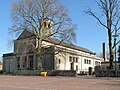 Oeffelt, church
 -
 Oeffelt, windmill: molen de Vooruitgang
 -
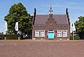 Oeffelt, monumental house
 -
 View on the Meuse


References[edit]
- ^ a b c "Kerncijfers wijken en buurten 2021". Central Bureau of Statistics. Retrieved 17 April 2022.
- ^ "Postcodetool for 5441AA". Actueel Hoogtebestand Nederland (in Dutch). Het Waterschapshuis. Retrieved 17 April 2022.
- ^ a b c d "Oeffelt". Plaatsengids (in Dutch). Retrieved 17 April 2022.
- ^ a b Chris Kolman & Ronald Stenvert (1997). Oeffelt (in Dutch). Zwolle: Waanders. ISBN 90 400 9945 6. Retrieved 17 April 2022.
- ^ Ad van der Meer and Onno Boonstra, Repertorium van Nederlandse gemeenten, KNAW, 2011.
External links[edit]
 Media related to Oeffelt at Wikimedia Commons