
Stanley Pontlarge: Difference between revisions
m Typo fixing , typos fixed: parishoners → parishioners using AWB |
→The Cottage: Added link Tags: Mobile edit Mobile web edit |
||
| (27 intermediate revisions by 23 users not shown) | |||
| Line 1: | Line 1: | ||
{{Use dmy dates|date=July 2015}} |
|||
[[Image:Stanley pontlarge view.JPG|thumbnail|right|300px|Fields at Stanley Pontlarge viewed from Langley Hill. Looking north to the Vale of Evesham. Note the steam train on the railway]]'''Stanley Pontlarge''' is a [[hamlet (place)|hamlet]] in [[Gloucestershire]], within the civil parish of Prescott and the ecclesiastical parish of [[Winchcombe]]. [[Image:stanley_pontlarge_lane.JPG|thumbnail|left|200px|Looking down the lane from the church towards the main road. Note the gable of the 14th century hall house (The Cottage) in mid-distance]]It is notable for its Norman church and for The Cottage, a 14th century house that was the home of [[Tom Rolt]], the writer on canals and industrial archaeology. [[Image:stanley_pontlarge_bridge.JPG|thumbnail|right|200px|Train crossing the bridge over the lane]] |
|||
{{Use British English|date=July 2015}} |
|||
{{Infobox UK place |
|||
| official_name= Stanley Pontlarge |
|||
| civil_parish = [[Prescott, Gloucestershire|Prescott]] |
|||
| country= England |
|||
| region= South West England |
|||
|coordinates = {{coord|51.971|-2.006|display=inline,title}} |
|||
| post_town= |
|||
| postcode_area= |
|||
| postcode_district= |
|||
| dial_code= |
|||
| shire_district= [[Tewkesbury Borough|Tewkesbury]] |
|||
| shire_county= [[Gloucestershire]] |
|||
| hide_services= Yes |
|||
| population = |
|||
| population_ref = |
|||
|static_image=stanley pontlarge lane.JPG |
|||
|static_image_caption=Looking down the lane from the church towards the main road. The gable of the 14th century house (The Cottage) in mid-distance |
|||
}} |
|||
'''Stanley Pontlarge''' is a village and former [[civil parish]], now in the civil parish of [[Prescott, Gloucestershire|Prescott]] and the ecclesiastical parish of [[Winchcombe]], in the [[Borough of Tewkesbury|Tewkesbury]] district, in the county of [[Gloucestershire]], England. Stanley Pontlarge lies on the steep northern escarpment of the Cotswolds. The [[Gloucestershire Warwickshire Railway]] is a prominent feature of the landscape. In 1931 the parish had a population of 43.<ref>{{cite web|url=https://visionofbritain.org.uk/unit/10391866/cube/TOT_POP|title=Population statistics Stanley Pontlarge Ch/CP through time|publisher=[[A Vision of Britain through Time]]|accessdate=7 December 2022}}</ref> |
|||
== History == |
|||
| ⚫ | |||
as "Stanlege".<ref>[http://www.stanleyroots.co.uk/Domesday.htm Stanley villages in the Domesday Book of 1086]</ref> |
|||
In 1310 Stanley Pontlarge became part of the parish of [[Toddington, Gloucestershire|Toddington]]. In 1386 the parish became a possession of [[Hailes Abbey]], but when the abbey was [[Dissolution of the Monasteries|dissolved]] in 1539 the parish of Toddington with Stanley Pontlarge became a normal parish with a vicar.<ref name=churchhistory>{{cite web|url=http://www.winchcombeparish.org.uk/winchcombe-parish/our-churches/historical-notes/a-brief-history-of-st-michaels-church-stanley-pontlarge.php|publisher=Winchcombe Parish|title=A Brief History of St Michael’s Church, Stanley Pontlarge|accessdate=22 April 2018}}</ref> In 1866 Stanley Pontlarge became a separate civil parish, but on 1 April 1935 the civil parish was abolished and absorbed into the civil parish of Prescott.<ref>{{cite vob|name=Stanley Pontlarge Ch/CP|url=http://www.visionofbritain.org.uk/unit/10391866|accessdate=22 April 2018}}</ref> |
|||
[[Image:stanley_pontlarge_church.JPG|thumbnail|200px|left|Church viewed from the west]] |
|||
| ⚫ | |||
== Church == |
|||
The |
The village has a small [[Church (building)|church]], whose original dedication is unknown. The church was probably built by Roger Little, who in about 1175 had married Margery, the daughter of [[Baron Sudeley|John de Sudeley]], and built the adjacent moated manor house.<ref name=churchhistory/> The original Norman structure was [[Victorian restoration|heavily restored]] by Thomas Collins in 1860-61. The chancel was rebuilt. The church is noted for its Late Norman north door, with chevron mouldings, and a Norman chancel arch, leaning outwards, also with chevron moulding. The nave roof was rebuilt in 1923-4 by Sir Philip Stott. The font is a Norman bowl, remodelled into an octagonal shape in the 14th century. Most of the furnishings in the church date to the 1860-1 restoration. By agreement among the parishioners, graves in the churchyard are not marked by headstones. A guide to the location of burials is provided within the church. |
||
== The Cottage == |
|||
The Cottage is 14th century in origin, probably built as a priest's house by Hailes Abbey after 1387, when the abbey was granted the living of Toddington and Stanley Pontlarge. Massive cruck trusses survive in the attic. The exterior of the house is 16th century in appearance, although the windows may date to the restoration by Thomas Collins in 1873. The Cottage was bought in 1921 by Lionel Rolt, and became the home of the writers Tom and Sonia Rolt in the 1950s. The house, and life in the surrounding countryside, are described in detail in Rolt's two volumes of autobiography ''Landscape with machines'' and ''Landscape with figures''. Tom Rolt is buried in the churchyard. |
The Cottage is 14th century in origin, probably built as a priest's house by Hailes Abbey after 1387, when the abbey was granted the living of Toddington and Stanley Pontlarge. Massive cruck trusses survive in the attic. The exterior of the house is 16th century in appearance, although the windows may date to the restoration by Thomas Collins in 1873. The Cottage was bought in 1921 by [[ L.T.C. Rolt|Lionel Rolt]], and became the home of the writers [[Tom Rolt|Tom]] and [[Sonia Rolt]] in the 1950s. The house, and life in the surrounding countryside, are described in detail in Rolt's two volumes of autobiography ''Landscape with machines'' and ''Landscape with figures''. Tom Rolt is buried in the churchyard. |
||
Stanley Pontlarge lies on the steep northern escarpment of the Cotswolds. The steep hillsides can appear bleak, but offer a superb view northwards to the [[Vale of Evesham]]. The [[Gloucestershire Warwickshire Railway]] is a prominent feature of the landscape. |
|||
A variety of ugly agricultural structures and overhead wires were removed by the [[Landmark Trust]] in the 1970s. |
A variety of ugly agricultural structures and overhead wires were removed by the [[Landmark Trust]] in the 1970s. |
||
| ⚫ | |||
| ⚫ | |||
{{reflist}} |
|||
== Further reading == |
|||
| ⚫ | |||
| ⚫ | |||
| ⚫ | |||
| ⚫ | |||
D. Verey & A. Brooks. 2002. ''The Buildings of England. Gloucestershire 2''. London: Yale University Press. |
D. Verey & A. Brooks. 2002. ''The Buildings of England. Gloucestershire 2''. London: Yale University Press. |
||
| ⚫ | |||
{{commonscat inline|Stanley Pontlarge}} |
|||
| ⚫ | |||
| ⚫ | |||
== Gallery == |
|||
<gallery> |
|||
File:Stanley pontlarge view.JPG|Fields at Stanley Pontlarge viewed from Langley Hill. Looking north to the Vale of Evesham. Note the steam train on the railway |
|||
File:stanley pontlarge church.JPG|Church viewed from the west |
|||
File:stanley pontlarge church door.JPG|The Norman door of the church |
|||
File:stanley pontlarge bridge.JPG|Train crossing the bridge over the lane |
|||
| ⚫ | |||
</gallery> |
|||
[[Category:Villages in Gloucestershire]] |
|||
[[Category:Borough of Tewkesbury]] |
[[Category:Borough of Tewkesbury]] |
||
[[Category: |
[[Category:Former civil parishes in Gloucestershire]] |
||
Latest revision as of 09:43, 31 July 2023
| Stanley Pontlarge | |
|---|---|
 Looking down the lane from the church towards the main road. The gable of the 14th century house (The Cottage) in mid-distance | |
 Stanley Pontlarge Location within Gloucestershire | |
| Civil parish | |
| District | |
| Shire county | |
| Region | |
| Country | England |
| Sovereign state | United Kingdom |
Stanley Pontlarge is a village and former civil parish, now in the civil parish of Prescott and the ecclesiastical parish of Winchcombe, in the Tewkesbury district, in the county of Gloucestershire, England. Stanley Pontlarge lies on the steep northern escarpment of the Cotswolds. The Gloucestershire Warwickshire Railway is a prominent feature of the landscape. In 1931 the parish had a population of 43.[1]
History[edit]
The village was mentioned in the Domesday Book of 1086, when it was referred to as "Stanlege".[2]
In 1310 Stanley Pontlarge became part of the parish of Toddington. In 1386 the parish became a possession of Hailes Abbey, but when the abbey was dissolved in 1539 the parish of Toddington with Stanley Pontlarge became a normal parish with a vicar.[3] In 1866 Stanley Pontlarge became a separate civil parish, but on 1 April 1935 the civil parish was abolished and absorbed into the civil parish of Prescott.[4]
Church[edit]
The village has a small church, whose original dedication is unknown. The church was probably built by Roger Little, who in about 1175 had married Margery, the daughter of John de Sudeley, and built the adjacent moated manor house.[3] The original Norman structure was heavily restored by Thomas Collins in 1860-61. The chancel was rebuilt. The church is noted for its Late Norman north door, with chevron mouldings, and a Norman chancel arch, leaning outwards, also with chevron moulding. The nave roof was rebuilt in 1923-4 by Sir Philip Stott. The font is a Norman bowl, remodelled into an octagonal shape in the 14th century. Most of the furnishings in the church date to the 1860-1 restoration. By agreement among the parishioners, graves in the churchyard are not marked by headstones. A guide to the location of burials is provided within the church.
The Cottage[edit]
The Cottage is 14th century in origin, probably built as a priest's house by Hailes Abbey after 1387, when the abbey was granted the living of Toddington and Stanley Pontlarge. Massive cruck trusses survive in the attic. The exterior of the house is 16th century in appearance, although the windows may date to the restoration by Thomas Collins in 1873. The Cottage was bought in 1921 by Lionel Rolt, and became the home of the writers Tom and Sonia Rolt in the 1950s. The house, and life in the surrounding countryside, are described in detail in Rolt's two volumes of autobiography Landscape with machines and Landscape with figures. Tom Rolt is buried in the churchyard.
A variety of ugly agricultural structures and overhead wires were removed by the Landmark Trust in the 1970s.
References[edit]
- ^ "Population statistics Stanley Pontlarge Ch/CP through time". A Vision of Britain through Time. Retrieved 7 December 2022.
- ^ Stanley villages in the Domesday Book of 1086
- ^ a b "A Brief History of St Michael's Church, Stanley Pontlarge". Winchcombe Parish. Retrieved 22 April 2018.
- ^ Great Britain Historical GIS / University of Portsmouth, Stanley Pontlarge Ch/CP. Retrieved 22 April 2018.
Further reading[edit]
D. Verey & A. Brooks. 2002. The Buildings of England. Gloucestershire 2. London: Yale University Press.
External links[edit]
![]() Media related to Stanley Pontlarge at Wikimedia Commons
Media related to Stanley Pontlarge at Wikimedia Commons
- Stanley Pontlarge church (Parish Website)
- Stanley Roots -- the roots of places and people called Stanley in medieval England.
Gallery[edit]
-
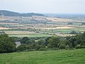 Fields at Stanley Pontlarge viewed from Langley Hill. Looking north to the Vale of Evesham. Note the steam train on the railway
 -
 Church viewed from the west
 -
 The Norman door of the church
 -
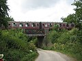 Train crossing the bridge over the lane
 -
 Bus shelter at junction of lane and main road, bearing the Latin inscription "Quilibet in tempestate portus" (A harbour in a storm for anyone)


