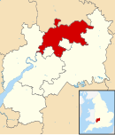
Borough of Tewkesbury
| Borough of Tewkesbury | |
|---|---|
 Location in Gloucestershire |
|
| status | Borough |
| region | South West England |
| Administration County | Gloucestershire |
| Administrative headquarters | Tewkesbury |
| surface | 414.42 km² (113.) |
| Residents | 79,200 (301.) |
| ONS code | 23UG |
| Website | www.tewkesburybc.gov.uk |
Tewkesbury is an administrative district with borough status in Gloucestershire in England . The administrative seat is Tewkesbury ; other significant places are Ashchurch , Bishop's Cleeve and Winchcombe . The district essentially comprises the rural area north of the cities of Cheltenham and Gloucester . In addition, with the villages of Churchdown , Innsworth and others, the more densely populated, suburban area between the aforementioned large cities. Among other things, there are larger shopping centers (hardware stores, Tesco supermarkets, car dealerships, etc.) as well as housing estates in the immediate catchment area of these cities.
The borough corresponds in terms of population and area and z. Partly with regard to the functions of a smaller district in Germany. Here it resembles a typical collar circle in a certain way , whereby in contrast to classic collar circles, even the surrounding areas of two large cities are combined in one regional authority.
The district was formed on April 1, 1974 and was the result of the merger of the Municipal Borough Tewkesbury, the Rural District Cheltenham and part of the Rural District Gloucester. He maintains a partnership with the Miesbach district in Upper Bavaria.
Coordinates: 52 ° 0 ′ N , 2 ° 10 ′ W
