
Çet Tepe
Coordinates: 36 ° 37 ′ 9.3 " N , 34 ° 14 ′ 30.8" E


The Çet Tepe is a hill in the urban area of Erdemli in southern Turkey . The ruins of a Roman farmyard are located on the hill .
location
The Çet Tepe is located about six kilometers northwest of the center of Erdemli, the ancient Kalanthia, in the district of the same name in the Mersin province . It is therefore close to a road leading from Kalanthia to Tetrapyrgia (today Kemer Yayla), which is listed in the Tabula Peutingeriana as a branch line connecting Iconion ( Konya ) to Pompeiopolis (near Mersin ). Today it can be reached via the road from Erdemli to Güzeloluk . The ancient settlement of Yapısıgüzel is about two kilometers to the southeast, the ancient settlement of Şaha, of which only a few house floor plans have remained, in the southeastern area, and the ruins of Köşkerli are 3.5 kilometers southwest .
description
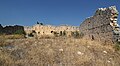
The building of the farmyard is oriented approximately from southeast to northwest and has an almost exactly square floor plan of 27.70 × 27.78 meters. The only entrance was in the middle of the south-east wall, the door was 1.66 meters wide. Apart from the south wall, which has completely disappeared except for the foundation, the walls have been preserved up to a height of six meters. The German Byzantinists Friedrich Hild and Hans Gerd Bright Kemper , who visited the place in 1985, still tell of the two in situ upright monoliths of the door jambs and a lintel verstürzten approximately in the middle of the southeast face. Around 25 rooms with doors opening onto the courtyard were lined up along the walls. A large part of the rooms can be reconstructed due to the partially preserved foundation walls and still recognizable wall connections or breakouts in the outer walls. They had areas of between 13 and 30 square meters. The support holes of the beams can still be seen in the outer walls of the ceiling at even intervals. In some places such beam holes can also be seen from the ceiling of the upper floor. No statements can be made about the room layout and orientation of the rooms on the upper floor. The remaining free area of the inner courtyard was about 280 square meters. The building was only illuminated in the outer walls through slit windows that were subsequently broken in, so the actual lighting of the rooms must have been from the courtyard side. The division of the rooms suggests the cultivation of grain, oil processing and livestock farming. Living areas are not visible, the apartment of the owner or manager must have been outside.
On the inside of the south-west wall, the scoop hole of a rock cistern has been preserved in one of the rooms, as well as on the outside of the north-west wall, where there is also another cistern carved into the rock with a shallow coupling. Outside the complex, Hild and Hellenkemper were able to observe at least four open oil presses and, in the north, the ruins of an imperial house.
The building can be dated to the late Roman period due to the double-walled small ashlar masonry and the monolithic door posts.

Vest corner
Interior from the southeast

West corner of the interior with foundation walls of the interior buildings

Scoop of a cistern in the inner southwest wall


literature
- Hansgerd Hellenkemper, Friedrich Hild: New research in Kilikien. Publications of the commission for the Tabula Imperii Byzantini Volume 4. Verlag der Österreichischen Akademie der Wissenschaften, Vienna 1986, ISBN 3-7001-0771-4 , pp. 89-92.
- Friedrich Hild , Hansgerd Hellenkemper : Kilikien and Isaurien. Tabula Imperii Byzantini Volume 5. Publishing house of the Austrian Academy of Sciences, Vienna 1990, ISBN 3-7001-1811-2 , pp. 225-226.
Web links
Individual evidence
- ↑ Friedrich Hild : The route of the Tabula Peutingeriana (Tab. Peut.) From Iconium via Ad Fines and Tetrapyrgia to Pompeiopolis in Kilikien In: Anatolia Antiqua, Tome 1, 1991. S. 316; ( Persée )