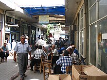
Erdemli
| Erdemli | ||||
|
||||
| Basic data | ||||
|---|---|---|---|---|
| Province (il) : | Mersin | |||
| Coordinates : | 36 ° 36 ' N , 34 ° 16' E | |||
| Height : | 10 m | |||
| Residents : | 46,903 (2010) | |||
| Telephone code : | (+90) 324 | |||
| Postal code : | 33xxx | |||
| License plate : | 33 | |||
| Structure and administration (as of 2011) | ||||
| Structure : | , | |||
| Mayor : | Mükerrem Tollu ( MHP ) | |||
| Website: | ||||
| Erdemli district | ||||
| Residents : | 126,538 (2010) | |||
| Surface: | 2,048 km² | |||
| Population density : | 62 inhabitants per km² | |||
| Kaymakam : | İbrahim Özefe | |||
| Website (Kaymakam): | ||||
Erdemli is the center of the district of the same name in the Turkish province of Mersin . The district is located in the center of the province and borders on Silifke in the west , Karaman province in the north and Mezitli and Toroslar in the east , both districts of the provincial capital Mersin . The city itself is located on the Mediterranean Sea on the D-400 coastal road ( Europastraße 90 ). The Alata River flows directly through the city into the Mediterranean. Erdemli has 46,903 and the district 126,538 inhabitants (as of 2010). 62 percent of the district is forest and 17 percent is used for agriculture.
The Erdemli district was formed in 1954 and, in addition to the city of Erdemli, had ten other municipalities ( Kızkalesi , Ayaş , Limonlu , Kocahasanlı , Esenpınar , Kumkuyu , Tömük, Çeşmeli, Kargıpınarı and Arpaçbahşiş) and 50 villages . Since a regional reform in 2014, they are all districts of Erdemli.
Erdemli is the site of the ancient settlement of Kalanthia. In the north-western district of Eski Erdemli (Alt-Erdemli) remains of an early Byzantine basilica can be seen. In the north-west of the urban area on the hill Çet Tepe are the ruins of a late Roman farmyard.
Worth seeing
There are several archaeological sites in the Erdemli district:
- Korykos with the sea and country castle as well as numerous surrounding ruins in the region around Kızkalesi
- the ruins of Kızılbağ , Hisarın , Çatıören , Emirzeli and Hacıömerli on the road leading north from Ayaş
- Settlements, some with churches, and graves in Şamlıgöl , Öküzlü , Batısandal , Yanıkhan , Köşkerli , Yapısıgüzel and Cambazlı
- the Hellenistic fortress ruins Yeniyurt Kalesi
- the roman villa rustica of Üçayaklı
- the rock tombs of Adamkayalar
- the ancient city of Elaiussa Sebaste in today's Ayaş
- the Roman-Byzantine building complex of Akkale
- the ancient city of Kanytelleis (Kanlıdivane) at a sinkhole
Web links
Individual evidence
- ↑ a b Turkish Institute for Statistics ( Memento from December 5, 2012 in the web archive archive.today ), accessed on June 11, 2011
- ↑ Friedrich Hild, Hansgerd Hellenkemper : Kilikien and Isaurien. Tabula Imperii Byzantini Volume 5. Verlag der Österreichischen Akademie der Wissenschaften, Vienna 1990, ISBN 3-7001-1811-2 , p. 281.


