
Korykos Castle
| Korykos Castle | ||
|---|---|---|
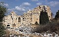
 Korykos Castle from the west |
||
| Creation time : | 1099 | |
| Castle type : | Seeburg | |
| Conservation status: | Ruin, parts of the wall and magnificent gate restored | |
| Construction: | Cuboid, small cuboid | |
| Place: | Kızkalesi | |
| Geographical location | 36 ° 27 '49 " N , 34 ° 9' 3" E | |
| Height: | 1 m | |
|
||

The medieval country castle of Korykos is located on the eastern outskirts of the resort of Kızkalesi in the Erdemli district of the Turkish province of Mersin , in the rugged Cilicia . It was built in late Byzantine times, had different owners and was in use until the conquest in the 15th century. It was located on the western edge of the ancient city of Korykos near its port. At its southwest corner, the remains of a pier can be seen that may have connected it to the Girls' Castle ( Turkish Kız Kalesi ), which is located on an island about 600 meters away.
history
After the place, which had been settled since Roman times, had lost its importance from the 11th century and had fallen into disrepair, the Megas Drungarios (fleet commander) Eustathios built the castle on the orders of the Byzantine emperor Alexios I in 1099 at the same time as the castle of Seleukeia , located about 25 kilometers southwest . It was supposed to secure the sea route to Cyprus and thus to the Holy Land for the Byzantine Empire . In the early 12th century, the castle and the city were probably conquered by the Armenian King Constantine I and then belonged to the Kingdom of Lesser Armenia . During this time, the fortress was considerably expanded and reinforced by a second wall ring. When the power of Lesser Armenia waned in the late 14th century and the city was threatened by the Karamanids , the inhabitants called on King Peter I of Cyprus for help. He sent the English knight Robert von Lusignan to Korykos. Under the rule of the House of Lusignan , the system was rebuilt again, with the inner fastening ring being massively reinforced and raised. After the conquest by the Karamanids in 1448 and the Ottomans in 1482, there is no further information about the castle.
construction
Attachment

The castle lies directly on the Mediterranean Sea to the south and west, with the harbor adjoining to the west and being protected by swampy terrain in the north. There was therefore only danger from the east, where the strongest fortifications are accordingly evident.
The southern outer wall, lying over cliffs, ends in a small tower to the east, and in the west in the sea gate, which allowed access to the castle from the water. It had a pointed arch and was flanked by two small towers and a small gate. The - as in the entire fortification - considerably stronger and higher inner wall also has only two corner towers, of which the eastern one has a protruding point and a groin vault inside .

The picture in the west is similar, the outer wall has no intermediate towers, the inner one has a smaller one in the middle. In addition, an ancient gate of Roman origin is integrated into the wall. According to Hellenkemper and Hild, it marks the beginning of the Cardo Maximus, the main axis of the Roman city, after Guyer and Herzfeld perhaps a monumental colonnaded street that led via a forum overbuilt by the castle to the two temples, the remains of which are to the east in the area of the outer bailey. The gate stands out from the adjoining medieval masonry on the side thanks to its neatly joined ashlar masonry. Its outer facade was divided into three parts by four pilasters with acanthus capitals . In the middle two smaller pilasters carried the 5.90 meter wide archway. In each of the side surfaces there was a niche with side pilasters and a gable. The lower end of it was a protruding console, which indicates that statues were erected there. The upper end of the gate was formed by an entablature made of a three-part architrave , transition profile and frieze, egg bar and row of teeth , above which acanthus-adorned consoles carried the geison closed with a sima . The gate is dated to the late 2nd or 3rd century AD, the masonry has now been restored.

At the northwest corner, a sloping tower that extends over the inner and outer walls closes off the west wall. The north face is not straight like the others, but follows the terrain profile in an outwardly bulging arch. The outer wall has only one further corner tower in the east, the inner wall has two protruding bastions in addition to the eastern corner tower . In the outer wall there are niches with loopholes.

The following east side is the most strongly fortified. Here lies the main structure of the fortress, which can be seen from afar, just behind the inner corner. It consisted of two mighty towers that were connected by a strong wall. The towers had several habitable floors with vaults and a crenellated platform at the top, remnants of which can still be seen on the north tower. A semicircular bastion jutted out from between the towers. Behind the connecting wall was a hall-like room with a barrel vault , of which the beginnings can still be seen. The main castle served here as a bulwark at the most endangered point, at the same time as a last refuge in the event that other parts were already taken. A few meters south of the main castle is the gate of the inner wall ring. The gate tower protrudes above the wall, especially on the inside, where parts of the stairs leading up are still preserved. An Armenian relief can be seen in the wall above the gate entrance with a machikuli shaft. It showed a cross set with precious stones, surrounded by rosettes and tendril ornaments and framed by a braided ribbon. Underneath, Guyer and Herzfeld saw parts of an illegible Armenian inscription that no longer exists today. Shortly after the entrance there is another bastion-like tower before the corner tower protruding to the east closes the inner wall.
The outer east wall is also stronger than any other. In the north there is a rectangular tower that opened inwards in an arch. It had loopholes on three sides. A considerable part of the staircase leading to the battlement is still preserved on its north side. This was followed by a triangular protrusion from the wall, from whose loopholes the trench in front of it could be seen on both sides. After a semicircular tower followed the roughly square gate tower with the main entrance of the fortress, also protruding outwards. A drawbridge or a wooden bridge probably crossed the moat there, as remains of a stone construction must have been preserved. As was customary in the Middle Ages, the entrance was not directly opposite the inner gate, but about 30 meters south of it. The entrance tower was also equipped with loopholes.
In front of the eastern wall was the moat mentioned above, which was probably filled with water from the stream flowing north of the castle in the rainy season. Behind it was the outer bailey, which was built at the same time, of which only very sparse traces have been preserved. It was therefore roughly rectangular in shape and bordered the sea in the south. There were various buildings inside, but they can no longer be identified. At most two chapels can be recognized from the floor plan, one of which was very close to the moat and therefore possibly older than the castle.
Building inside

Inside the castle, relics of several buildings can be seen, three of which can be recognized as churches. The largest of these is located in the southwest of the area. It had a nave 4.07 meters wide and 7.23 meters long, followed by a slightly narrower, 1.51 meter deep transition to the choir and, in the east, a 3.30 meter wide and 2.17 meter deep apse . While today only the north wall and the apse with the choir stand upright, Guyer and Herzfeld could still describe all walls almost up to the roof. After that the building had a door in the south and one in the west wall. The lighting was provided by two high windows on the long sides and three in the western gable. There was also a window in the apse and an opening in the top of the choir arch. While this had the shape of a barrel vault, Guyer and Herzfeld suspected a beam ceiling for the ship because of the weaker side walls. About 20 meters east of this church, the remains of a much smaller chapel can be seen, which only has a 3.70 × 3.86 meter nave and an apse 2.20 meters wide and 1.38 meters deep.
In the northeast corner of the interior of the castle there was another, the largest church in the complex. It was originally built as a three-aisled basilica. The interior of the central nave including the apse was 17.60 meters long and 7.00 meters wide, the side aisles were 2.35 meters wide. The apse was 6.00 meters wide and 3.50 meters deep and had an arched window - later walled up - in the apex and a similar door in the north wall. On its back, parts of two wall pillars and the beginnings of round arches have been preserved, which point to a vaulting of a room behind, perhaps a sacristy. In the course of a later renovation, the church was greatly reduced in size. The west wall with the entrance was moved 5.95 meters to the east and the spaces between the pillars separating the ships were walled up so that a single-nave building was created. The resulting interior was divided into three yokes by two pilasters in the longitudinal walls . The wall pillars were connected with blind arches and supported a barrel vault. In this second construction period, the walls were plastered and decorated with paintings, of which Victor Langlois saw Armenian holy images in the apse in 1852/53. Guyer and Herzfeld report remains of ornaments on the blind arches. The masonry of the church consists of the small blocks characteristic of Armenian architecture.
The other buildings within the castle have only been preserved in remnants and cannot be identified more precisely. One is behind the entrance in the east, two more, similar to the crusader castles, directly on the fortress wall, one in the southwest and one in the west near the grand gate. Both are divided into small rooms and therefore may have served as storage rooms. A 3.5 × 4.5 meter cistern can be seen near the main plant , which used to be covered. Hild and Hellenkemper suspect cisterns in the last two buildings.
North church from the southeast

Walls and apse of the north church from the south-west

Painting remains on the south wall

Small chapel near the south church


Masonry and spoilage


The fortress walls are mainly made of existing stones from older buildings. The largest part consists of cuboids of different sizes, in the main work in the east there are also embossed cuboids, which presumably originate from previous Roman buildings, according to Hild and Hellenkemper, mainly from imperial burial houses of the necropolis. A large number of spoils are built into the walls , numerous inscription stones and other architectural fragments, but also column shafts. Guyer and Herzfeld suspect of the latter that they came from the colonnaded street that began at the Roman grand gate integrated into the western wall and led to the temples east of the castle grounds. It is noteworthy that in several towers of the north and east wall these column parts are integrated at regular intervals according to a recognizable pattern, so that one can assume that the builders were pursuing decorative goals with them. In stark contrast to this is the very small-scale masonry used in the upper parts, especially the north wall, which can also be observed, for example, in the Armenian churches in the urban area. Nevertheless, Guyer and Herzfeld assume that it comes from the same construction period.
A particular example of the spoils used are two marble blocks that are used in the wall to the right and left of the main entrance in the outer wall. On the original altar stones from a Roman temple, the text of a decree of the Byzantine Emperor Anastasios I from around 500 is engraved. In it, at the instigation of Bishop Indakos, the provincial government is prohibited from interfering in the elections of the defensor (ἔκδικος) - an official who mediated between the city and the central government - and the curator (ἔφορος).
In the warehouse near the southwest church, a stone block with an engraved menorah has been reused as a lintel . This, along with numerous other occurrences of Jewish symbols and names in the Korykos necropolis, is evidence of the presence of a Jewish community in the city, as in many other places in the area.
Research history
_p243_-_CHATEAU_ARMENIEN_DE_GORGHIOS.jpg)
As early as the 14th century, Guillaume de Machaut provides a description of the castle in his epic La Prize d'Alexandrie , in which he tells of the military campaign of the Cypriot King Peter I against Alexandria. The British captain Francis Beaufort , who explored the Cilician coast on behalf of the Admiralty in the years 1811-12, reports that the pier starting at the sea gate protruded about 100 m into the sea and ended with a platform for a lighthouse. The French orientalist Victor Langlois traveled to Cilicia from 1852-1853 and described the castle in his travelogue Voyage dans la Cilicie et dans les montagnes du Taurus. The Austrian archaeologist Rudolf Heberdey traveled from 1890 to 1891 with his compatriot, the classical philologist Adolf Wilhelm , Cilicia and visited Korykos. In 1907, the archaeologist Ernst Herzfeld and the Swiss art historian Samuel Guyer visited the site and provided the first detailed description of the two castles. The archaeologist Josef Keil and the philologist Adolf Wilhelm documented numerous inscriptions from Korykos in 1914, including the aforementioned imperial decree. The Byzantinist Hansgerd Hellenkemper has researched the fortress several times since 1969, sometimes together with Friedrich Hild , where they came to new insights and interpretations.
literature
- Ernst Herzfeld; Samuel Guyer: Meriamlik and Korykos. Two Christian ruined cities of the rough Cilicia , Monumenta Asiae minoris antiqua 2, Manchester 1930 pp. 90–189
- Hansgerd Hellenkemper: Crusader castles in the county of Edessa and in the Kingdom of Lesser Armenia. Studies on the historical settlement geography of Southeast Asia Minor (Geographica historica Volume 1) . Habelt, Bonn 1976, ISBN 377491205-X , pp. 242-249.
- Friedrich Hild, Hansgerd Hellenkemper: Kilikien and Isaurien. Tabula Imperii Byzantini Volume 5. Publishing house of the Austrian Academy of Sciences, Vienna 1990, ISBN 3-7001-1811-2 , pp. 315-320.
Web links
- Theodora Stillwell MacKay: Korykos Rough Cilicia, Turkey . In: Richard Stillwell et al. a. (Ed.): The Princeton Encyclopedia of Classical Sites. Princeton University Press, Princeton NJ 1976, ISBN 0-691-03542-3 .
- Korykos, Kizkalesi and Narlikuyu
Individual evidence
- ^ Victor Langlois: Voyage dans la Cilicie et dans les montagnes du Taurus: exécuté pendant les années 1851-1853 ... B. Duprat, 1861, p. 212 ( limited preview in Google Book search).
- ^ Josef Keil , Adolf Wilhelm : Monuments from the rough Cilicia , (= MAMA 3), Manchester 1931, pp. 122–129
- ^ Sviatoslav Dmitriev: City Government in Hellenistic and Roman Asia Minor . Oxford University Press, 2005, ISBN 0-19-534690-4 , pp. 213 ( limited preview in Google Book search).
- ^ Serra Durugönül, Ahmet Mörel: Evidence of Judaism in Rough Cilicia and its Associations with Paganism. In: Istanbul communications. 62, 2012, pp. 303-322.
- ^ Victor Langlois: Voyage dans la Cilicie et dans les montagnes du Taurus: exécuté pendant les années 1851-1853 ... B. Duprat, 1861, p. 202 ( limited preview in Google Book search).
- ^ Francis Beaufort: Karamania. A Brief Description of the South Coast of Asia Minor and os the Remains of Antiquity. R. Hunter, London 1818, pp. 241 f.
- ^ Rudolf Heberdey, Adolf Wilhelm: Reisen in Kilikien 1891-1892 (Vienna 1896, Denkschriften Wien 44/6), p. 67f.