Hisarın
Coordinates: 36 ° 30 ′ 26.7 " N , 34 ° 9 ′ 26" E
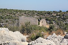
Hisarın (also Hisarınkale or Hisarkale ) refers to the ruins of a settlement from the Hellenistic to the early Byzantine era with a fortification in the rough Cilicia in southern Turkey.
location
Hisarın is located in the Erdemli district of the Turkish province of Mersin , about 15 kilometers southwest of the district center Erdemli and 50 kilometers southwest of the provincial capital Mersin . It belongs to the Kızılbağ corridor and is therefore treated under this name by some researchers, although it is more than a kilometer away from the Roman- Early Byzantine settlement of the same name . The Hisarın fortifications are located northeast of the Kızılbağ settlement, mostly on the steep western slope of a valley that stretches from the coastal town of Ayaş (the ancient Elaiussa Sebaste ) on the Mediterranean Sea into the mountainous interior. It can be reached via the road that runs from Ayaş to Esenpınar in the north, passing the ruins of Kızılbağ, Çatıören , Emirzeli and Hacıömerli . About three kilometers after Ayaş, a dirt road branches off to the right, which takes another kilometer to Hisarın.
Attachment
A defensive wall facing west with a length of 16.76 meters and a height of about 10 meters stands on a crest that slopes steeply on three sides at the edge of the gorge. At the northern end it bends to the east, so that the viewer coming from the west has the impression of a tower. This is followed by a lower wall that stretches down the slope to the bottom of the valley. There is an entrance to it near the junction. Both walls are made of polygonal masonry . On the southwest corner and the northwest corner of the wall as well as on a collapsed lintel to the west of it, three clubs in relief are attached as Olbic symbols . The defensive wall was repaired or extended in the upper area in the Roman or Byzantine period with small blocks using mortar technology. Presumably at the same time, another component with an entrance was added to the south end of the wall. In the north-west corner, the wall with the east-facing walls forms a two-storey tower-like structure. Later changes can also be seen here. In the southern part, the main wall is reinforced with eight meter high buttresses. The Turkish archaeologist Serra Durugönül , who together with her German colleague Hanns Gabelmann researched and measured the towers in the Rough Cilicia in 1995 , assumes that a wooden parapet rested on it, which was also supported by wooden pillars and served defensive purposes. Whether the wall above was equipped with battlements or loopholes can no longer be determined due to the renovations.
The Olbian symbols indicate that the building belongs to the Hellenistic priestly state of Olba and Diokaisareia , probably members of the ruling priestly dynasty or members of the military lived here. According to this and according to the type of masonry, Durugönül dates the wall or the tower (she speaks of a "dummy tower") to the 2nd century BC. Chr.
settlement
Houses made of polygonal masonry are distributed over the slope in the south and east. In the west, the German archaeologists Rudolf Heberdey and Adolf Wilhelm found a semicircular foundation and a Doric capital during their trip to Cilicia in 1891/92 . In the west there are two also polygonally bricked, small grave houses, further south there are three more grave houses, one of them larger and with carefully smoothed large cuboids. On the opposite eastern side of the gorge there is an ancient settlement with sarcophagi and a basilica . In the rock face below, Heberdey and Wilhelm saw rock graves with reliefs.
literature
- Rudolf Heberdey , Adolf Wilhelm : Journeys in Kilikien 1891-1892 (= memoranda of the Academy of Sciences. Volume 44, 6). Vienna 1896, p. 66 ( digitized version ).
- Friedrich Hild , Hansgerd Hellenkemper : Kilikien and Isaurien. Tabula Imperii Byzantini Volume 5. Publishing house of the Austrian Academy of Sciences, Vienna 1990, ISBN 3-7001-1811-2 , pp. 303-304 (sv Kızılbağ ).
- Serra Durugönül : towers and settlements in the Rough Cilicia. Asia Minor Studies Volume 28. Rudolf Habelt, Bonn 1998 ISBN 3-7749-2840-1 pp. 46–49, panels 21–24.
Web links
Individual evidence
- ↑ Among others by Hild and Hellenkemper


