
Emirzeli
Coordinates: 36 ° 32 ′ 37 ″ N , 34 ° 6 ′ 9 ″ E


Emirzeli (also İmirzeli ) is the Turkish name for a ruin site in Rough Cilicia , which was inhabited from the Hellenistic to the Byzantine period. It consists of a hill with houses and a fortification tower as well as three churches and necropolis remains arranged in a row on the slope of another hill.
location
Emirzeli is located at an altitude of 590 meters about two kilometers west of the village Karaahmetli in the district of Erdemli in the Turkish province of Mersin . The distance from Kızkalesi , the ancient Korykos , is about ten kilometers, as is Ayaş ( Elaiussa Sebaste ). The place is three kilometers northwest of Çatıören on the road that leads from Elaiussa Sebaste via Kızılbağ , Hisarın and Çatıören to Esenpınar , Öküzlü , Sömek and Cambazlı and further on to Uzuncaburç , the ancient Olba .
Research history
In the 1970s, Semavi Eyice was the first Emirzeli to undertake a more detailed investigation as part of an inventory program of the Byzantine remains in the Silifke area (Seleukia am Kalykadnos), with the architect I. Birol Alpay drawing up a plan. In 1983 and 1985 Friedrich Hild and Hansgerd Hellenkemper visited and described the place. In 1998 Serra Durugönül carried out a more detailed examination of the Olbian defense tower as part of an investigation into the towers and settlements in the Rough Cilicia . Ayşe Aydın described Church II in more detail in her dissertation in 1999. Excavations have not yet taken place.
description


The main settlement of Emirzeli was on a limestone ridge with approximate dimensions of 300 by 100 meters, which extends from northeast to southwest. On the slope to the south of it there are three churches and a scattered necropolis .
Settlement hill
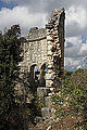
The most striking structure is a multi-storey tower in the east of the rock ridge, built in a polygonal construction. It has approximate external dimensions of 9.0 × 8.6 meters, the height was between 11.0 and 13.6 meters, the interior measured 3.64 × 3.71 meters. A door and a window on the second floor were on the southwest side, the top layers are repaired with smaller isodomic stones from the late Roman - Byzantine period. Bar holes for the mezzanine floors can be seen in the interior, and slotted windows were on each floor. A phallic relief is attached to one of the lower corner stones of the almost completely collapsed southeast side . This symbol is one of a number of Olbic symbols widespread in the region , which indicate that the tower and perhaps also the settlement belonged to the sphere of influence of the Olba priestly dynasty. The tower is the oldest building in the village. Due to masonry techniques, it can be dated to the end of the 3rd to the beginning of the 2nd century BC. To be dated. Remains of a defensive wall adjoin the tower to the northwest, also from the Hellenistic period, which extends further to the southwest over the hill.
About 60 meters south of the tower are the remains of an at least two-storey manorial house from the early Byzantine period. Its entrance is on the northwest side, on the lintel is a medallion with a cross, which is flanked by two peacocks. Inside, the ground floor is divided into two parts by a belt arch . Below this, a peristyle can be seen on the slope , of which three non-fluted Doric columns and the architrave have been preserved on the narrow side and four on the long side . It probably belonged to a Roman house.
Around the south-western tip of the hill and on the north-western side there are still the ruins of numerous no longer definable buildings, some of which were built in polygonal masonry and therefore at the same time as the tower. There are also rock niches, perhaps graves. The time of building remains, a cistern and lintels in the area east of the tower cannot be determined.

Phallic relief on the tower

Early Byzantine house from the southwest, rock niches in front

Lintel with cross and peacocks

Peristyle from the north


Churches


On the slope opposite to the south, below the modern road and the hamlet of the same name, are the remains of three church buildings, called Church I to Church III at Semavi Eyice from southwest to northeast. Church I, the largest of the three, presumably had three naves , as there are three entrances into the naos in the southwest of the partially preserved narthex . The narthex was two-story, which indicates possible galleries above the aisles. Nothing has been preserved from the interior, the main apse still stands in the northeast . It has a well-preserved twin window, the central column of which is adorned with a capital with acanthus leaves . On both sides of the main apse there were side rooms, which were also equipped with apses, as well as another room behind the apse.
Church II is the most complete. This is also a three-aisled basilica with a narthex. The walls are made of small cuboids using the two-shell technique with a mortar backfill and are 55–60 centimeters thick. The building measures 14.3 × 29.3 meters. The building is erected on a plateau sloping to the northwest, the southeast wall is the least preserved. From the two-storey narthex, which is largely destroyed except for the north-west wall, three entrances led into the three naves. A three-arched opening from the upper floor to the central nave can be seen above. The naos has dimensions of 13 × 15 meters. The side aisles are separated from the central nave by rows of columns with arcades . The width of the side aisles is 3.0 meters each and that of the central nave is 6.1 meters. The pillars have capitals with eight large, undivided leaves. In the area of the central nave in front of the apse, a recess can be seen in the first column, which suggests a part of a Templon system stored there . There are two fallen cuboids on the floor, on which an inscription indicates a ΓΕΩΡΓΙΟΣ ΠΑΥΛΟΣ (Georgios Paulos) as the donor. However, it is not clear whether he donated the church or possibly only part of it, such as the Templon. In addition to the entrances from the narthex, there is only one door to the main room in the northwest wall, the destroyed southeast wall was on the slope side and probably only had windows. The apse had a surrounding bench, the apse forehead rested on pilaster capitals . The Naos was illuminated through three windows in the northwest wall, an unknown number in the southeast wall and probably, as is common in churches of this type, through an upper balcony . From beam holes in the walls it can be concluded that there are galleries above the aisles.
Noteworthy are the two-storey side rooms next to and behind the apse, which protrude beyond the apse. Two roughly right-angled rooms are to the right and left of the apse. They are divided into two sub-rooms by a belt arch. They are both closed to the northeast by a semicircular apse. Behind the main apse, both are connected by doors to another rectangular room that opens outwards in an arch. In the southeastern room the remains of a staircase to the gallery can be seen. There is a door threshold above the door from the right to the middle room, which also results in the existence of an upper floor. The right room only had two barred slot windows on the ground floor, and a rectangular window on the upper floor. The left side room had a door on the first floor and two rectangular windows on the upper floor. The Turkish Byzantinist Ayşe Aydın, who researched the church in the late 1990s, suggests that the basilica may have been a pilgrimage church. The right side room would have been the place where a relic was kept, so that the pilgrims could enter the church through the main entrance, then pass the object to be venerated in this room, and then either leave the building through the middle room and its arched exit or via the left Adjoining room and the northwest aisle to get out of the door there. Apse side rooms of this type are only known from a few examples in Cilicia, otherwise only from Syria. The Thekla Church in the Ayathekla (Meriamlik) shrine near Silifke , which was a well-known place of pilgrimage in the 5th and 6th centuries, can be used as a model. Aydın dates Church II to this same time due to the construction techniques and capital shapes.
Apart from a few door frames, nothing has been preserved from Church III to the northeast. Semavi Eyice also reconstructs it in his drawing as a three-nave basilica with a narthex and protruding apse side rooms. The remains of a necropolis with imperial sarcophagi and chamosoria can be seen in the vicinity .
Apse of Church I from the southwest

Church II from the southwest

Church II north-west aisle

Church II central nave

Interior Church II with arcades from the southeast

Donor inscription


literature
- Friedrich Hild, Hansgerd Hellenkemper: Kilikien and Isaurien. Tabula Imperii Byzantini Volume 5. Verlag der Österreichischen Akademie der Wissenschaften, Vienna 1990, ISBN 3-7001-1811-2 , p. 249
- Semavi Eyice: Some Byzantine small towns in the Rough Cilicia , in: 150 years of the German Archaeological Institute. Philipp von Zabern 1981 p. 208 ISBN 9783805304771
- Serra Durugönül: towers and settlements in the Rough Cilicia. Asia Minor Studies Volume 28. Rudolf Habelt, Bonn 1998 pp. 35–41 ISBN 3-7749-2840-1
- Ayşe Aydın: Emirzeli - a Hellenistic to late antique settlement in the Rauhen Kilikien , Marburg, Tectum-Verlag 1999 ISBN 3-8288-0541-8
- Ina Eichner: Early Byzantine houses in Cilicia. Architectural history study of the types of housing in the region around Seleukeia on the Kalykadnos (= Istanbul Research Vol. 52). Wasmuth, Tübingen 2011, pp. 126-161 ISBN 978-3-8030-1773-4 .