
Çatıören

Çatıören ( Turkish for roof ruins ) is the Turkish name for a ruin site from the Hellenistic - Roman - Early Byzantine times in the rough Cilicia in southern Turkey .
location
Coordinates: 36 ° 31 '17 " N , 34 ° 7' 34" E

The remains of the settlement are in the Erdemli district of the Mersin province , about 20 kilometers southwest of the district town of Erdemli and 60 kilometers west of the provincial capital Mersin . You are in the mountainous hinterland of Ayaş , the ancient Elaiussa Sebaste , six kilometers from the Mediterranean Sea, on the road that leads from Ayaş via Kızılbağ and Emirzeli to Sömek , Cambazlı and on to Olba and Diokaisareia .
building


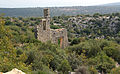
The ruins are grouped around a limestone spur that is oriented northwest-southeast. At its north-western end there is a simple temple with a floor area of around 130 square meters. All walls are made of double-shell polygonal masonry . Its cella has the shape of a slightly warped rectangle, the approximately four meters protruding ante are at another slightly oblique angle. In the resulting pronaos , which opened to the southeast, there were originally two columns without fluting , of which individual drums are located in the vicinity. The door with a monolithic lintel is offset slightly to the right from the center, on both sides and above there is a narrow, high niche. The middle is flanked by two reliefs as Olbische sign a Caduceus show. To the right of the entrance, slightly deepened, there is an inscription about the prohibition of Cilician measurements. With the polis mentioned in it is probably meant Elaiussa Sebaste. A foundation inscription lies overturned in the pronaos, it designates a Pomponius Niger as Hermes priest , which leads to the identification of the temple. A window is set in the middle of the south-west wall, the other two walls have a high rectangular niche. There is no clarity about the roof construction. The wall to the pronaos seems to have been preserved in full, the two side walls, on the other hand, rise slightly, which suggests a triangular gable and a ridge running above it. There is no processional path to the temple, nor is there any way to walk around it, as it takes up the entire width of the ridge.
To the south-east of the temple there is an Olbian tower on the rock, also of polygonal construction, with a wall of the same type facing northeast. Below this are several houses of the same construction, also on the southern and eastern slopes of the spur and in the surrounding valley.
On the northeastern opposite slope, on the road, are the ruins of a three-aisled basilica with galleries and ambulatory . Their ships are separated by a series of five or six columns, the shafts and bases of which are in the interior. Overhanging cuboids on the north corner of the west wall indicate that the construction of a narthex was planned. A corner of the wall slightly moved away from the south wall on the south-west corner could have been intended as the foundation for this porch. Churches with planned or later added narthexs are not uncommon in Cilicia, examples are Demirciören, Cambazlı or Kadırlı. In the northern area of the basilica there is an imperial necropolis with rock reliefs and burial houses.
The oldest buildings in the place are from the 3rd to 2nd century BC. Dated to the 2nd to 1st century BC, according to the inscriptions. Similar simple temple buildings are otherwise not known from southern Anatolia. Traces of a Byzantine rededication were not found, possibly because the building was architecturally unsuitable for it.
West wall of the basilica
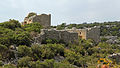
Tower and Hermes temple from the east, in the pronaos the reliefs can be seen on both sides of the niche

Hellenistic house walls on the southern slope of the rock spur


Research history
The first visitor to the ruins of Çatıören was British archaeologist James Theodore Bent in the 1880s. In the following decade, the Austrian archaeologist Rudolf Heberdey traveled with his compatriot, the classical philologist Adolf Wilhelm , Cilicia and also Çatıören. In the 1980s, Hansgerd Hellenkemper and Friedrich Hild explored the site. The Turkish archaeologist Serra Durugönül was there in the 1990s. Bent identified the place as a base , which Heberdey and Wilhelm judged as "erroneous".
Web links
- ancient settlement near Çatıören data set in Arachne , the central object database of the German Archaeological Institute (DAI) and the Archaeological Institute of the University of Cologne
literature
- James Theodore Bent: A Journey in Cilicia Tracheia In: The Journal of Hellenic Studies Vol. 12, 1891, pp. 210 f.
- Rudolf Heberdey, Adolf Wilhelm: Journeys in Kilikien 1891-1892 (Vienna 1896, memoranda Vienna 44/6), p. 66f.
- Friedrich Hild, Hansgerd Hellenkemper: Kilikien and Isaurien. Tabula Imperii Byzantini Volume 5. Publishing house of the Austrian Academy of Sciences, Vienna 1990, ISBN 3-7001-1811-2 , pp. 224–225.
- Hansgerd Hellenkemper, Friedrich Hild: New research in Kilikien. Publications of the commission for the Tabula Imperii Byzantini Volume 4. Verlag der Österreichischen Akademie der Wissenschaften, Vienna 1986, ISBN 3-7001-0771-4 , pp. 73-77.
- Serra Durugönül: towers and settlements in the Rough Cilicia. Asia Minor Studies Volume 28. Rudolf Habelt, Bonn 1998 ISBN 3-7749-2840-1 pp. 28–33, 120–122 et passim.
- Ina Eichner: Early Byzantine houses in Cilicia. Architectural history study of the types of housing in the region around Seleukeia on the Kalykadnos (= Istanbul Research Vol. 52). Wasmuth, Tübingen 2011, pp. 118-125 ISBN 978-3-8030-1773-4 .