
Îlot des Capucins
| Îlot des Capucins | ||
|---|---|---|
 |
||
| Waters | Atlantic Ocean | |
| Geographical location | 48 ° 19 '8 " N , 4 ° 34' 58" W | |
|
||
| length | 120 m | |
| width | 90 m | |
| surface | 0.1 ha | |
| Residents | uninhabited | |

The small Îlot des Capucins ( islet of the Capuchins ) in the Atlantic Ocean is a rocky island on the Pointe des Capucins in Roscanvel on the north side of the Crozon Peninsula in the Finistère department in Brittany in France . Its name comes from a rock near the island that is shaped like a praying monk .
Fortress
The strategic fortress "Fort des Capucins" was built in 1848 according to old plans by Sébastien Le Prestre de Vauban (1633–1707). With its artillery batteries it controlled, together with the Fort de la Fratenite on the Îlot du Diable and the Fort du Petit Minou in the north (near Kérangoff, west of Brest ) the access to the 3.0 km long and 1.5 km wide Strait of Brest and the bay of Camaret-sur-Mer . Numerous adjustments were made in the 1880s and 1890s. In 1917 the two 47-ton guns were dismantled.
- Îlot des Capucins with the fort


location


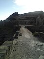


The barracks are made of slate and granite and blend into the landscape. The island is connected to the land by a bridge from 1859. The fort was badly damaged by bombs during World War II.
Web links
- Îlot des Capucins in the Base Mérimée of the French Ministry of Culture (French)