
Crozon Peninsula
| Crozon Peninsula | ||
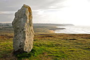
 Pointe de Dinan - play of colors in the water and on the rock |
||
| Geographical location | ||
|
||
| Coordinates | 48 ° 15 ′ 39 " N , 4 ° 30 ′ 0" W | |
| Waters 1 | Atlantic Ocean | |

The Crozon peninsula ( Breton Gourenez Kraozon , French Presqu'île de Crozon ) is located in the far west of the Finistère department in the northwest of the Brittany region , between Brest and Quimper . The entire peninsula belongs to the Armorique Regional Nature Park ( French Parc naturel régional d'Armorique ), the only nature park in Brittany.

Worth seeing
Sandy beaches framed by rock formations invite you to swim , heather fields with gorse and honeysuckle for hiking along the cliffs. From Ménez-Hom (Bret. Menez C'homm ), a 330 m high mountain near Plomodiern on the road from Châteaulin to Crozon , there is a view to the west over the Crozon peninsula to the Mer d'Iroise , to the north over the Rade de Brest to Brest and to the southwest over the Bay of Douarnenez .
The coast is rich in bays and has numerous cliffs, often more than 100 meters high. In addition to the highest cliff at Cap de la Chèvre , numerous other rocky cliffs alternate with long sandy beaches. The Pointe de Penhir near Camaret-sur-Mer or the Pointe de Dinan west of Crozon form bizarre rock bastions made of quartzite . The cliffs have many grottos, including the Morgat grottoes .
In the north, the Roscanvel peninsula has played an important military role since the late Middle Ages due to its strategic location at the narrowest point of the Goulet de Brest , the entrance to the Rade de Brest. The coast of the Roscanvel Peninsula is therefore, starting from the Pointe des Espagnols , lined with a large number of remains of gun emplacements and forts. Even today, the military is one of the most important employers on the peninsula: the Île Longue submarine base is the location of the French nuclear submarines .
Historical
The peninsula was one of the places where prehistoric people built their sanctuaries ( Dolmen of Rostudel , Dolmen of Pen-ar-Run , Menhir la Républicaine, rows of stones from Lagatjar ). They are known thanks to the descriptions of Christophe Paulin de la Poix de Fréminville , Chevalier de Fréminville (1787–1848) and Jean-Marie Bachelot de La Pylaie (1786–1856), and were still in 1830 grandiose complexes. Around 1910, Lieutenant A. Devoir, who was tasked with rescuing them, could only secure the remains. The Landouadec and Leure facilities in the north of the peninsula counted more than 300 menhirs, of which only scattered remains can be found today. Some alignments were supplemented by stone circles (Landouadec). An interesting place is the Iron Age foothills fort at Pointe de Lostmarc'h , a ski jump that is sealed off from the land by a double ditch. The rectangular stone enclosure at Ty-ar-C'huré near Morgat is probably from the Bronze Age .
The great menhir at the Pointe de Lostmarc'h

The Fort des Capucins on the Îlot des Capucins in Roscanvel


See also
.JPG)
- Canton of Crozon , administrative division of the peninsula
- List of regional natural parks in France
- Pointe de Saint-Hernot
literature
- Jean-Marie Bachelot de La Pylaie: Études archéologiques et geographiques . Ed .: Société archéologique du Finistère à Quimper. 1970 (reprint of the 1850 edition).
- Loius Calvez: La presqu'île de Crozon - Histoire - Art - Nature . In: Monographies des villes et villages de France . 2nd Edition. 2008, ISBN 978-2-84373-744-2 , ISSN 0993-7129 .
Web links
- Pays du Ménez-Hom Atlantique Portal for the promotion of tourism on the Crozon Peninsula
- Maison des Minéraux de St. Hernot. The geology of the Crozon Peninsula
- Images of the Crozon Peninsula
Individual evidence
- ↑ Calvez 2008, p. 22