Östergarnsberget
Östergarnsberget ( German Östergarnsberg ) is an inland cliff in the parish ( Swedish socken ) Östergarns in the east of the Swedish island of Gotland . In earlier times the sea level was higher than Gotland and the Östergansberget was part of a cliff coast.
location
Östergarnsberget is 1.5 km south of Katthammarsvik , 41 km south-east of Visby , 12 km north of Ljugarn and 25 km south-east of Roma .
Nature reserve
Large parts of the mountain form a nature reserve which was established in 2005 and covers 193 hectares. It is even a Natura 2000 area.
nature
The mountain, which was once formed from a coral reef , is made of reef limestone . Ice and water have shaped the mountain over thousands of years and created caves, some of which are more than ten meters deep. The highest part of the mountain, which is 42 m above sea level, is just inside the Mattsarveklint cliff in the northwest. From the top of the cliff you have a great view.
The plateau on top of the mountain is dominated by Hällmark , which is a landscape form that occurs in Scandinavia, which consists of rocky subsoil with almost no humus layer and is overgrown by light, small forest. This goes over to a sparse and low growing pine forest . The 14 hectare Gannemyr bog is also located here . The humus layer is thin and the vegetation, for example hot stonecrop and sand thyme , is sparse. In the southwestern part of the nature reserve, the top soil layer consists partly of sand and the coniferous forest is denser there and also contains individual spruce trees .
The high plateau is closed off by a steep slope to the west, north and east, but the mountain drops only slightly towards the south. Below the slopes are often remains of rock falls, made up of blocks and stones that have been detached from the sides of the mountain through weathering. A deciduous forest dominated by ash trees and pine trees grows on the northern and eastern rockfalls . On the stony ground you can also find Ruprecht's herb , ciliate pearl grass and the rare fern plant Ruprecht's fern .
Both the top is on the Östergarnsberget and below the steep slopes of the mountain a variety of unusual plants, such as the two kinds of fern hart and Gymnocarpium Robertianum, the diminutive Alvargewächs Kalknarv ( latin arenaria gothica ) and Low rocket ( latin Sisymbrium supinum ) and orchids as anacamptis pyramidalis , Red forest bird and heart two-leaf ( Latin listera cordata )
One of the characteristic birds of the Östergarnsberget is the woodlark , which chirps high up in the air above the mountain in spring and early summer.
Large parts of the Östergarnsbergets are grazed by sheep.
Limestone quarry
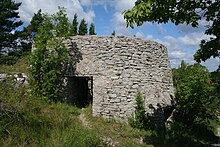
There are many traces of previous limestone mining on the Östergarnsberget. Right where the road to Katthammarsvik branches off from the road to Östergarn Church , there is a restored ruin of a lime kiln , 15 m in diameter and eight m high.
Right next to it is the so-called Flyktingkällan ( German refugee source ), a memorial stone for the Latvians who fled to Gotland towards the end of World War II . South-east of the lime kiln ruins and a little off the road that leads up the mountain, there is a large quarry by the cliff Gutenviksklint . Lime kiln ruins are also to be found at Kaupungskling in the southeast and at Grönskogshuvud in the southwest.
Källinghagen
Directly west of the Östergarnberget and next to the regional road from Katthammarsvik to the church of Gammelgarn is the small nature reserve Källinghagen. This was designated in 2005 and it covers eleven hectares. It is dominated by old coniferous forest with sprinkles of open wetlands , of which the Majvät bog is the largest. It is a so-called agmyr (Swedish for a chalk- rich moor in which the rush edge ( Swedish ag ) is dominant).
Individual evidence
- ↑ a b c d e f g h Östergarnsberget. Länsstyrelsen i Gotlands län, accessed February 9, 2013 (Swedish).
- ↑ Hällmarksskog in the Swedish Wikipedia
- ^ Häll in the Swedish Wikipedia
- ↑ Arenaria gothica Fr. In: Den virtuella floran. Retrieved February 9, 2013 (Swedish).
- ^ Sisymbrium supinum L. In: Den virtuella floran. Retrieved February 9, 2013 (Swedish).
- ↑ Listera cordata (L.) R. Br. In: Den virtuella floran. Retrieved February 9, 2013 (Swedish).
- ↑ 1. Östergarn lime kiln - entry in the "Fornsök" database of the Riksantikvarieämbetet (Swedish). Retrieved on 2013-02-09
- ↑ Inscription - entry in the database "Fornsök" of the Riksantikvarieämbetet (Swedish). Retrieved on 2013-02-09
- ↑ 2. Östergarn lime kiln - entry in the "Fornsök" database of the Riksantikvarieämbetet (Swedish). Retrieved on 2013-02-09
- ↑ 3. Östergarn lime kiln - entry in the "Fornsök" database of the Riksantikvarieämbetet (Swedish). Retrieved on 2013-02-09
- ↑ Källinghagen. Länsstyrelsen i Gotlands län, accessed February 9, 2013 (Swedish).
swell
- Jens-Henrik Kloth, Ulf Lovén: Gotlands nature - en reseguide . Bonniers and Länsstyrelsen Gotland, 1987, ISBN 91-34-50860-0 .
Web links
- Östergarnsberget (short). (PDF) In: segotland.se. Retrieved February 9, 2013 (Swedish).
- Östergarnsberget (long). (PDF) In: segotland.se. Retrieved February 9, 2013 (Swedish).
- Östergarnsberget. In: guteinfo.com. Retrieved February 9, 2013 (Swedish).
- Östergarnsberget. In: gotland.net. Retrieved February 9, 2013 (Swedish).
- Östergarnsberget (Natura 2000). (PDF; 246 kB) länsstyrelsen, accessed on February 9, 2013 (Swedish).
- Östergarnsberget. länsstyrelsen, accessed February 9, 2013 (Swedish).
- Östergarnsberget. In: EUNIS. European Environment Agency, accessed February 9, 2013 .
Coordinates: 57 ° 25 ′ 13 ″ N , 18 ° 50 ′ 29 ″ E
