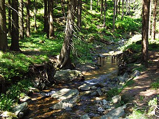
Černá Opava
|
Černá Opava (German: Black Oppa ) |
||
|
Černá Opava (Black Oppa) |
||
| Data | ||
| location | Moravskoslezský kraj , Czech Republic | |
| River system | Or | |
| Drain over | Opava → Or → Stettiner Haff | |
| source | West slope of Orlík in the Jeseníky Mountains 50 ° 10 ′ 42 ″ N , 17 ° 17 ′ 12 ″ E |
|
| Source height | 1040 m nm | |
| muzzle | in Mnichov in the Opava Coordinates: 50 ° 7 ′ 31 ″ N , 17 ° 22 ′ 46 ″ E 50 ° 7 ′ 31 ″ N , 17 ° 22 ′ 46 ″ E |
|
| Mouth height | 528 m nm | |
| Height difference | 512 m | |
| Bottom slope | 36 ‰ | |
| length | 14.4 km | |
| Catchment area | 58.6 km² | |
| Drain |
MQ |
870 l / s |
| Residents in the catchment area | 970 | |
The Černá Opava (German Black Oppa ) is the left source river of the Opava in the Czech Republic.
course
The Černá Opava rises on the western slope of the Orlík ( Urlichkoppe , 1203 m) at the saddle Kristovo loučení in the Jeseníky Mountains . It first flows north past the Opavská chata and the Russian forest cemetery and turns north-east at Kazatelny (925 m). The Černá Opava flows around the Zámecký vrch (933 m) with the remains of the castle Koberštejn ( Koberstein ) and changes its direction to the south. In its deep valley lie the villages of Drakov and Mnichov. Between Mnichov, Železná and pod Vrbno Pradědem opens the Černá Opava 14.4 kilometers in the basin of vrbno pod pradědem in the Opava .
North of Zámecký vrch, the Údolím lapků z Drakova nature trail leads from Starý Rejvíz along the stream to Vrbno pod Pradědem. From the Hegerhaus Drakov, the Černá Opava is navigable for the lower seven kilometers.
Tributaries
- Bublavý potok (l), from the high moor Malé mechové jezírko ( Small Sühnteich ) near Starý Rejvíz
- Podzámecký potok (r), at the chata "U Rejvízkého mostu"
- Slučí potok (r), opposite the desert Drakov Castle ( Drachenburg )
- Sokolí potok (r), at the former Josefský Hamr
- Rudná (r), above Mnichov
- Suchý potok (r), Mnichov
Web links
- http://www.pod.cz/plan-oblasti-povodi-Odry/inf_listy/prilohy/021_RL_VU.pdf
- http://www.turistika.cz/mista/cerna-opava
- http://www.jesenik.net/index.php?obl=1&kat=11&sluz=93&pol=2801
